List of State Register of Heritage Places in the Town of East Fremantle
This is a list of State Register of Heritage Places in the Town of East Fremantle, Western Australia. The State Register of Heritage Places is maintained by the Heritage Council of Western Australia.
As of 2020, 1,126 places are heritage-listed in the Town of East Fremantle,[1] of which fifteen are on the State Register of Heritage Places.[2]
List
The Western Australian State Register of Heritage Places, as of 2020, lists the following fifteen state registered places within the Town of East Fremantle:
| Place name | Place # | Street number | Street name | Suburb or town | Co-ordinates | Notes & former names | Photo |
|---|---|---|---|---|---|---|---|
| East Fremantle Post Office (former) | 787 | 101 | Canning Highway | East Fremantle | 32.041225°S 115.762407°E | .jpg) | |
| East Fremantle Town Hall | 788 | 135 | Canning Highway | East Fremantle | 32.041210°S 115.763051°E | .jpg) | |
| Public Buildings, East Fremantle | 789 | 101, 133 & 138 | Canning Highway | East Fremantle | 32.041208°S 115.762595°E | East Fremantle Post Office, Police Station, Town, Mechanics Institute & Library & PO Group SES Headquarter | 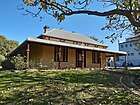 |
| Woodside Hospital | 792 | 18 | Dalgety Street | East Fremantle | 32.041377°S 115.771808°E | Moore Family Residence, Woodside | 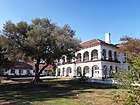 |
| Royal George Hotel | 794 | 34 | Duke Street | East Fremantle | 32.043929°S 115.763455°E | Royal Hotel, Royal George Arts and Community Centre | 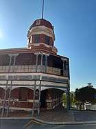 |
| Ferniehurst | 799 | 15 | Parker Street | East Fremantle | 32.032126°S 115.766405°E | Ferryhurst, House & Gardens | |
| Aldgate | 802 | 7 | Aldgate Place | East Fremantle | 32.037716°S 115.765344°E | ||
| Knocknagow | 803 | 24 | Preston Point Road | East Fremantle | 32.038128°S 115.764741°E | ||
| Woodlawn | 805 | 20 | Osborne Road | East Fremantle | 32.039954°S 115.769818°E | ||
| Glanville's Buildings | 3352 | 5A & 5B | Riverside Road | East Fremantle | 32.041377°S 115.759327°E | ||
| Penshurst | 3694 | 49, 51 & 53 | View Terrace | East Fremantle | 32.033061°S 115.772158°E | ||
| House, 26 King Street | 4645 | 26 | King Street | East Fremantle | 32.042764°S 115.762431°E | ||
| Palm Trees | 10323 | 208 | Canning Highway | East Fremantle | 32.040372°S 115.769829°E | Part of Woodlawn Precinct (805) | |
| East Fremantle Honour Roll, Council Offices | 12112 | 135 | Canning Highway | East Fremantle | 32.041210°S 115.763051°E | Part of Public Buildings, East Fremantle Precinct (789) | |
| Former Police Station | 24909 | 133 | Canning Highway | East Fremantle | 32.041208°S 115.762595°E | 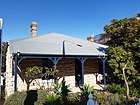 |
References
- "Town of East Fremantle Heritage Places". inherit.stateheritage.wa.gov.au. Heritage Council of Western Australia. Retrieved 28 April 2020.
- "Town of East Fremantle State Register of Heritage Places". inherit.stateheritage.wa.gov.au. Heritage Council of Western Australia. Retrieved 28 April 2020.
This article is issued from Wikipedia. The text is licensed under Creative Commons - Attribution - Sharealike. Additional terms may apply for the media files.