Levasy, Missouri
Levasy is a city in Jackson County, Missouri, United States. The population was 83 at the 2010 census. It is part of the Kansas City metropolitan area.
Levasy, Missouri | |
|---|---|
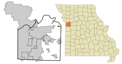 Location of Levasy, Missouri | |
| Coordinates: 39°8′7″N 94°7′56″W | |
| Country | United States |
| State | Missouri |
| County | Jackson |
| Government | |
| • Mayor | Phyllis Dieckmann |
| Area | |
| • Total | 0.60 sq mi (1.56 km2) |
| • Land | 0.60 sq mi (1.56 km2) |
| • Water | 0.00 sq mi (0.00 km2) |
| Elevation | 712 ft (217 m) |
| Population | |
| • Total | 83 |
| • Estimate (2019)[3] | 82 |
| • Density | 136.21/sq mi (52.58/km2) |
| Time zone | UTC-6 (Central (CST)) |
| • Summer (DST) | UTC-5 (CDT) |
| ZIP code | 64066 |
| Area code(s) | 816 |
| FIPS code | 29-41762[4] |
| GNIS feature ID | 0720926[5] |
History
A post office called Levasy has been in operation since 1877.[6] The city was named after William Wallace Livesay, an early settler.[7]
Geography
Levasy is located at 39°8′7″N 94°7′56″W (39.135174, -94.132157).[8]
According to the United States Census Bureau, the city has a total area of 0.60 square miles (1.55 km2), all land.[9]
Demographics
| Historical population | |||
|---|---|---|---|
| Census | Pop. | %± | |
| 1910 | 66 | — | |
| 1920 | 146 | 121.2% | |
| 1930 | 215 | 47.3% | |
| 1940 | 126 | −41.4% | |
| 1950 | 139 | 10.3% | |
| 1960 | 140 | 0.7% | |
| 1970 | 283 | 102.1% | |
| 1980 | 235 | −17.0% | |
| 1990 | 279 | 18.7% | |
| 2000 | 108 | −61.3% | |
| 2010 | 83 | −23.1% | |
| Est. 2019 | 82 | [3] | −1.2% |
| U.S. Decennial Census[10] | |||
2010 census
At the 2010 census there were 83 people in 39 households, including 27 families, in the city. The population density was 138.3 inhabitants per square mile (53.4/km2). There were 47 housing units at an average density of 78.3 per square mile (30.2/km2). The racial makup of the city was 97.6% White and 2.4% from two or more races. Hispanic or Latino of any race were 3.6%.[2]
Of the 39 households, 20.5% had children under the age of 18 living with them, 56.4% were married couples living together, 5.1% had a female householder with no husband present, 7.7% had a male householder with no wife present, and 30.8% were non-families. 28.2% of households were one person, and 10.3% were one person aged 65 or older. The average household size was 2.13 and the average family size was 2.56.
The median age was 50.3 years. 14.5% of residents were under the age of 18; 4.7% were between the ages of 18 and 24; 24% were from 25 to 44; 39.7% were from 45 to 64; and 16.9% were 65 or older. The gender makeup of the city was 48.2% male and 51.8% female.
2000 census
As of the census[4] of 2000, there were 108 people in 40 households, including 33 families, in the city. The population density was 187.1 people per square mile (71.9/km2). There were 46 housing units at an average density of 79.7 per square mile (30.6/km2). The racial makup of the city was 99.07% White and 0.93% Native American.
Of the 40 households, 25.0% had children under the age of 18 living with them, 70.0% were married couples living together, 7.5% had a female householder with no husband present, and 17.5% were non-families. 17.5% of households were one person, and 7.5% were one person aged 65 or older. The average household size was 2.70 and the average family size was 2.97.
In the city the population was spread out, with 24.1% under the age of 18, 5.6% from 18 to 24, 29.6% from 25 to 44, 25.0% from 45 to 64, and 15.7% 65 or older. The median age was 42 years. For every 100 females, there were 107.7 males. For every 100 females age 18 and over, there were 105.0 males.
The median household income was $51,250 and the median family income was $60,250. Males had a median income of $40,000 versus $24,688 for females. The per capita income for the city was $17,016. There were 3.2% of families and 5.1% of the population living below the poverty line, including 3.3% of under eighteens and 23.1% of those over 64.
References
- "2019 U.S. Gazetteer Files". United States Census Bureau. Retrieved July 26, 2020.
- "U.S. Census website". United States Census Bureau. Retrieved 2012-07-08.
- "Population and Housing Unit Estimates". United States Census Bureau. May 24, 2020. Retrieved May 27, 2020.
- "U.S. Census website". United States Census Bureau. Retrieved 2008-01-31.
- "US Board on Geographic Names". United States Geological Survey. 2007-10-25. Retrieved 2008-01-31.
- "Post Offices". Jim Forte Postal History. Retrieved 16 October 2016.
- "Jackson County Place Names, 1928–1945 (archived)". The State Historical Society of Missouri. Archived from the original on 24 June 2016. Retrieved 16 October 2016.CS1 maint: BOT: original-url status unknown (link)
- "US Gazetteer files: 2010, 2000, and 1990". United States Census Bureau. 2011-02-12. Retrieved 2011-04-23.
- "US Gazetteer files 2010". United States Census Bureau. Archived from the original on 2012-01-25. Retrieved 2012-07-08.
- "Census of Population and Housing". Census.gov. Retrieved June 4, 2015.
Municipalities and communities of Jackson County, Missouri, United States | ||
|---|---|---|
| Cities | 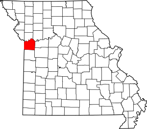 Map of Missouri highlighting Jackson County | |
| Villages | ||
| Townships | ||
| Unincorporated communities | ||
| Footnotes | ‡This populated place also has portions in an adjacent county or counties | |
Kansas City metropolitan area's cities and counties | ||
|---|---|---|
| Central city | 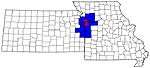 | |
| Largest cities (over 100,000 in 2000) | ||
| Medium-sized cities (10,000 to 100,000 in 2000) | ||
| Smaller Cities (between 5,000 and 9,900 in 2010) | ||
| Counties | ||