Lee's Creek Township, Washington County, Arkansas
Lee's Creek Township is one of thirty-seven townships in Washington County, Arkansas, USA.[2] As of the 2000 census, its total population was 640.
Township of Lee's Creek | |
|---|---|
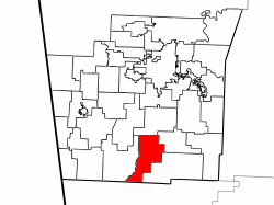 Location of Lee's Creek Township in Washington County | |
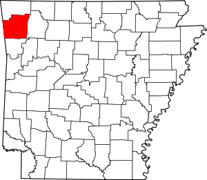 Location of Washington County in Arkansas | |
| Coordinates: 35°49′0″N 94°11′46″W | |
| Country | |
| State | |
| County | Washington |
| Established | 1880[1] |
| Area | |
| • Total | 33.1 sq mi (86 km2) |
| • Land | 33.1 sq mi (86 km2) |
| • Water | 0.0 sq mi (0 km2) 0% |
| Elevation | 1,621 ft (494 m) |
| Population (2000) | |
| • Total | 640 |
| • Density | 19/sq mi (7/km2) |
| Time zone | UTC-6 (CST) |
| • Summer (DST) | UTC-5 (CDT) |
| Area code(s) | 479 |
| GNIS feature ID | 69793 |
| U.S. Geological Survey Geographic Names Information System: Lee's Creek Township, Washington County, Arkansas | |
Lee's Creek Township was established in 1880.[3]
Geography
According to the United States Census Bureau, Johnson Township covers an area of 33.1 square miles (86 km2), all land.[2] Devil's Den State Park makes up the southern tip of the township. The township was created from parts of Cove Creek Township and Crawford Township in 1880.[1]
Cities, towns, villages
Cemeteries
The township contains Blackburn Cemetery.
Major routes
References
- United States Census Bureau 2008 TIGER/Line Shapefiles
- United States Board on Geographic Names (GNIS)
- United States National Atlas
- Baker, Russell (1985). Arkansas Township Atlas 1819-1930. Hot Springs, AR: Arkansas Genealogical Society. p. 202. OCLC 11528205.
- "Township of Lee's Creek, Washington County, Arkansas". U.S. Census Bureau. Retrieved August 29, 2010.
- History of Benton, Washington, Carroll, Madison, Crawford, Franklin, and Sebastian Counties, Arkansas. Higginson Book Company. 1889. p. 167.
External links
Places adjacent to Lee's Creek Township, Washington County, Arkansas | ||||||||||
|---|---|---|---|---|---|---|---|---|---|---|
| ||||||||||
This article is issued from Wikipedia. The text is licensed under Creative Commons - Attribution - Sharealike. Additional terms may apply for the media files.