Jamestown, Rhode Island
Jamestown is a town in Newport County, Rhode Island in the United States. The population was 5,405 at the 2010 census. Jamestown is situated almost entirely on Conanicut Island, the second largest island in Narragansett Bay. It also includes the uninhabited Dutch Island and Gould Island. Jamestown is ranked as the 444th wealthiest place to live in the United States as of 2016, with a median home sale price of $1,229,039.[3]
Jamestown, Rhode Island | |
|---|---|
 Jamestown Windmill, built in 1787 | |
 Location of Jamestown in Newport County, Rhode Island | |
| Coordinates: 41°31′N 71°22′W | |
| Country | United States |
| State | Rhode Island |
| County | Newport |
| Government | |
| • Type | Council - Administrator form of government |
| • Administrator | Jamie Hainsworth |
| • Town Council | Michael G. White (D) Mary E. Meahger (D) Nancy E. Beye (I) Raandall White (D) William J. Piva, Jr. (R) |
| • Moderator | John A. Murphy (D) |
| Area | |
| • Total | 35.3 sq mi (91.5 km2) |
| • Land | 9.7 sq mi (25.1 km2) |
| • Water | 25.6 sq mi (66.4 km2) |
| Elevation | 167 ft (51 m) |
| Population (2010) | |
| • Total | 5,405 |
| • Density | 557.2/sq mi (215.3/km2) |
| Time zone | UTC−5 (Eastern (EST)) |
| • Summer (DST) | UTC−4 (EDT) |
| ZIP code | 02835 |
| Area code(s) | 401 |
| FIPS code | 44-36820[1] |
| GNIS feature ID | 1220061[2] |
| Website | Town website |
Geography
According to the United States Census Bureau, the town has an area of 35.3 square miles (91 km2), of which 9.7 square miles (25 km2) is land and 25.6 square miles (66 km2) is water. The total area is 72.55% water.
Rhode Island Route 138 is the only state highway in Jamestown, connecting the town and island to North Kingstown to the west (over the Jamestown Verrazzano Bridge) and Newport to the east (over the Newport Bridge).
History
In 1524, Italian navigator Giovanni da Verrazzano and his crew visited Narragansett Bay.[4] Dutch Island was used by fur traders c. 1622,[5] and English colonists made arrangements to use Conanicut Island for grazing sheep in 1638.

Ferries were in operation between Conanicut Island and Newport by 1675. In 1678, Conanicut Island was incorporated as the town of Jamestown,[6] when there were about 150 residents. It was named for James, Duke of York, who became King James II in 1685.[7]
By 1710, many of Conanicut Island's current roads were in place. In 1728, the town of Jamestown built a windmill for grinding corn,[8] which used the sea breeze for power since there was no source of running water to turn a waterwheel.
American Revolution
Two hundred British and Hessian troops, commanded by James Wallace, landed at East Ferry on Conanicut Island on December 10, 1775.[9][10] They then marched to West Ferry where they burned the ferry house.[10] As they returned to East Ferry, they destroyed many buildings, including 14 homes, which caused more than 200 of Conanicut Island's 556 residents to flee to the mainland.
In December 1776, a British fleet arrived in Narragansett Bay and occupied Newport.[11] The British took over the colonial militia batteries at Fort Dumpling (now part of Fort Wetherill) and the Conanicut Battery at Beavertail, just south of Fort Getty at the end of Battery Lane. They left Narragansett Bay in October 1779; as they departed, they destroyed the fortifications which they had occupied and burned down the Beavertail Lighthouse.[11]
18th and 19th centuries
Beavertail Lighthouse was back in operation by 1784, and Jamestown rebuilt the Jamestown Windmill and Quaker Meetinghouse in 1787 that had been destroyed during the occupation.
In 1800, Fort Dumpling was established on the site of previous fortifications overlooking East Passage. A tall stone tower atop the highest cliff could hold eight guns.
The town of Jamestown commissioned a steam-powered ferryboat in 1872 and initiated service between Jamestown and Newport in May 1873. The availability of reliable and comfortable ferry service to and from Newport had a significant impact on agricultural Conanicut Island, and Jamestown became a destination for both day trips and summer vacations.
The 1880s and 1890s saw a construction boom, with hotels, private summer homes, and municipal buildings going up. The island's population tripled between 1870 and 1900.
20th century to the present
There was a burst of military fortification activity from 1890 to the end of World War I. The Spanish–American War was a catalyst, beginning in 1898, and work began on Dutch Island's Fort Greble. The War Department bought 31 acres (130,000 m2) for Fort Getty, and fortifications were quickly erected. Summer homes were condemned near Fort Dumpling to establish Fort Wetherill. More land was acquired at Prospect Hill near the Conanicut Battery site for an observation and fire control station, and the government established a torpedo station and test facility on Gould Island. Then, at the end of the First World War, the Conanicut Island fortifications fell into disuse. World War II brought establishment or reactivation of military bases around Narragansett Bay, including Forts Getty, Burnside, and Wetherill on Conanicut Island, Fort Greble on Dutch Island, a torpedo factory on Goat Island, and a torpedo station on Gould Island.

Jamestown was a bustling summer destination in the early 1900s, and it had nine hotels in 1903. The golden age of large resort hotels was brief, however, in Jamestown and elsewhere, and patronage rapidly declined in the 1920s. The Thorndike Hotel was demolished in 1938. The Gardner House was one of the larger hotels, but it was taken down in 1941 after being idle for several years, and a USO building was built on its site. After the war, the town purchased the building and it is now known as the community center. It was extensively landscaped and remodeled in 2002. The Bay View Hotel closed in the 1960s, the last of the very large hotels. The building was demolished in 1985, and the Bay View Condominiums opened for occupancy four years later. The building exterior was designed to resemble the hotel. The Bay Voyage Hotel is the only survivor of the many hotels that once lined Jamestown's eastern harbor, now operating as a time share resort.
In 1938, a major hurricane caused much property damage and the loss of more than 300 lives in the Narragansett Bay region. It swept away much of the sand from the Mackerel Cove beach, destroyed its popular beach pavilion, and destroyed the West Ferry docks—which actually speeded approvals for a bridge to Saunderstown. The first Jamestown Bridge opened in the summer of 1940, replacing West Ferry service with a continuously available link to the west.
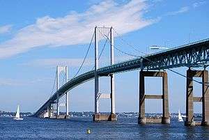
In 1969, the Claiborne Pell Newport Bridge was completed, establishing Route 138 as a continuous highway from South County to Newport. With its completion, traditional ferry service was eliminated. The bridge is pictured on the Rhode Island commemorative quarters. In 1992, the Jamestown-Verrazano Bridge replaced the narrow steel bridge erected in 1940. It was accompanied by construction of a new western-end access road and a cross-Conanicut Island highway.

Demographics
| Historical population | |||
|---|---|---|---|
| Census | Pop. | %± | |
| 1790 | 507 | — | |
| 1800 | 501 | −1.2% | |
| 1810 | 504 | 0.6% | |
| 1820 | 448 | −11.1% | |
| 1830 | 415 | −7.4% | |
| 1840 | 365 | −12.0% | |
| 1850 | 358 | −1.9% | |
| 1860 | 400 | 11.7% | |
| 1870 | 378 | −5.5% | |
| 1880 | 459 | 21.4% | |
| 1890 | 707 | 54.0% | |
| 1900 | 1,091 | 54.3% | |
| 1910 | 1,175 | 7.7% | |
| 1920 | 1,633 | 39.0% | |
| 1930 | 1,599 | −2.1% | |
| 1940 | 1,744 | 9.1% | |
| 1950 | 2,068 | 18.6% | |
| 1960 | 2,267 | 9.6% | |
| 1970 | 2,911 | 28.4% | |
| 1980 | 4,040 | 38.8% | |
| 1990 | 4,999 | 23.7% | |
| 2000 | 5,622 | 12.5% | |
| 2010 | 5,405 | −3.9% | |
| Est. 2015 | 5,482 | [12] | 1.4% |
| U.S. Decennial Census[13][14] | |||
As of the census[1] of 2000, there were 5,622 people, 2,359 households, and 1,625 families residing in the town. The population density was 580.0 people per square mile (224.0/km2). There were 2,769 housing units at an average density of 285.7 per square mile (110.3/km2). The racial makeup of the town was 97.55% White, 0.78% African American, 0.21% Native American, 0.39% Asian, 0.00% Pacific Islander, 0.23% from other races, and 0.84% from two or more races. 0.89% of the population were Hispanic or Latino of any race.
There were 2,359 households, out of which 28.3% had children under the age of 18 living with them, 58.5% were married couples living together, 8.0% had a female householder with no husband present, and 31.1% were non-families. 25.9% of all households were made up of individuals, and 9.9% had someone living alone who was 65 years of age or older. The average household size was 2.38 and the average family size was 2.88.
In the town, the population was spread out, with 22.0% under the age of 18, 4.3% from 18 to 24, 25.4% from 25 to 44, 33.5% from 45 to 64, and 14.7% who were 65 years of age or older. The median age was 44 years. For every 100 females, there were 94.6 males, and for every 100 females age 18 and over, there were 91.6 males.
The median income for a household in the town was $87,073, and the median income for a family was $117,990. Males had a median income of $50,185 versus $35,056 for females. The per capita income for the town was $58,664. 2.9% of the population and 1.7% of families were below the poverty line. 1.4% of those under the age of 18 and 3.1% of those 65 and older were living below the poverty line.
Jamestown Public Schools encompasses two buildings: Melrose School for elementary students and Lawn School for middle school students. For high school, public school students matriculate to either North Kingstown High School or Narragansett High School.[15]
In popular culture
Portions of several movies have been filmed in and around Jamestown, including Wind; Me, Myself & Irene; American General; Evening; Dan in Real Life; Moonrise Kingdom; and Irrational Man. The comic strip Wallace the Brave was created and drawn by Jamestown resident Will Henry and set in the fictional Rhode Island town of Snug Harbor, which is loosely based on Jamestown.[16]
Notable people
- Governor Benedict Arnold purchased land in Jamestown 1657, great-grandfather of the notorious turncoat Benedict Arnold
- Brenda Bennett, musician and former member of Vanity 6, currently resides in Jamestown.[17]
- Architect Charles L. Bevins (1844–1925) lived in Jamestown
- John Biddle (yachting cinematographer) spent his childhood summers here and later moved back to the island, living there until his death.[18]
- Bacteriologist Eleanor Albert Bliss was born in Jamestown
- Caleb Carr (governor) lived in Jamestown and was buried on the island
- John A. Cloud, former United States Ambassador to the Republic of Lithuania, lives here
- Dwight Dickinson, former United States Ambassador to Togo, lived here
- Daniel Fones leading Rhode Island military commander in King Georges War, was born and raised in Jamestown
- Paul Housberg lives here, a glass artist recognized for his use of fused and kiln formed glass as an architectural medium
- Luke McNamee, four-star admiral and Governor of Guam, lived in Jamestown[19]
- John Mecray, marine painter and co-founder of the Museum of Yachting, lived in Jamestown[20]
- Jonathan M. Nelson, founder of Providence Equity Partners, built a home in Jamestown in 2009
- Peter F. Neronha, the current Rhode Island Attorney General and former United States Attorney for the District of Rhode Island, was born, raised, and currently resides in Jamestown
- Landscape artist William Trost Richards lived and worked on the island from 1881 till death in 1905
- Marla Romash, political consultant and pastry chef, currently resides in Jamestown[21]
National Historic Places and notable sites in Jamestown

- Artillery Park
- Beavertail Lighthouse
- Thomas Carr Farmstead Site (Keeler Site RI-707)
- Conanicut Battery
- Conanicut Island Lighthouse
- Dutch Island Lighthouse
- Fort Dumpling Site
- Fort Getty
- Friends Meetinghouse (Jamestown, Rhode Island)
- Hazard Farmstead (Joyner Site RI-706)
- Horsehead-Marbella
- Jamestown Archeological District
- Jamestown Windmill
- Old Friends Archeological Site
- Watson Farm
- Windmill Hill Historic District
References
- "U.S. Census website". United States Census Bureau. Retrieved January 31, 2008.
- "US Board on Geographic Names". United States Geological Survey. October 25, 2007. Retrieved January 31, 2008.
- Sharf, Samantha (December 8, 2016). "Full List: America's Most Expensive ZIP Codes 2016". Forbes.com. Retrieved April 17, 2017.
- Ronda, James P. (August 26, 2014). "Black Gowns and Massachusetts Men: Indian-White Relations in New England to 1701". In Weeks, Philip (ed.). "They Made Us Many Promises": The American Indian Experience 1524 to the Present. Harlan Davidson (Wiley). pp. 3–4. ISBN 978-1-118-82282-1.
- Parsons, Usher (February 1863). "Indian Relics Recently Found in Charlestown, R. I. with Brief Notices of the Nyantic Tribe of Indians". The Historical Magazine. 7 (2): 42.
The Dutch soon opened trading stations; one at Quotenis, or Dutch Island as it is now called … Hither were brought furs by the Indians to exchange for Dutch goods, insomuch that when in 1622 or 3 the Pilgrims of Plymouth sent to this place a small vessel laden with beads and knives, they found the Indians abundantly supplied already with these …
- Brinley, Francis (April 1882). "Conanicut Island". The Newport Historical Magazine. 2 (4): 193.
In 1678, Mr. Caleb Carr and Mr. Francis Brinley, on behalf of themselves and the proprietors, for Quononoqutt Island (the Indian name for Conanicut Island), petitioned to the General Assembly for an act of Incorporation, which was then granted (Nov. 4, 1678) …
- Gannett, Henry (1905). The Origin of Certain Place Names in the United States. Govt. Print. Off. pp. 168.
- Stevens, Maud Lyman (1916). The Jamestown Windmill. Newport, Rhode Island: R. Ward. p. 7. OCLC 1047470243.
… our first positive record [of a windmill] appears in 1728. In July of that year the proprietors and freemen at a quarterly meeting voted the erection of a windmill.
- Hellmann, Paul T. (February 14, 2006). Historical Gazetteer of the United States. Routledge. p. 959. ISBN 978-1-135-94859-7.
- Force, Peter, ed. (1837). "Conanicut (Rhode Island) Plundered". American Archives. 4th series. 4. Washington, DC: M. St. Clair Clarke and Peter Force. p. 230.
- Neimeyer, Charles P. (2010). "The British Occupation of Newport Rhode Island 1776–1779". Army History (74): 30–45. ISSN 1546-5330. JSTOR 26296027.
- "Annual Estimates of the Resident Population for Incorporated Places: April 1, 2010 to July 1, 2015". Archived from the original on June 2, 2016. Retrieved July 2, 2016.
- "Census of Population and Housing". United States Census Bureau. Retrieved June 4, 2016.
- Snow, Edwin M. (1867). Report upon the Census of Rhode Island 1865. Providence, RI: Providence Press Company.
- Gibbs, Ryan (September 10, 2015). "Back to school: 491 children settle in class". The Jamestown Press. Retrieved September 4, 2016.
- Hill, John. "R.I. comics creator draws on childhood memories". providencejournal.com. Retrieved 20 April 2019.
- Shane, Ken (February 19, 2015). "Former Vanity 6 singer inducted into RI Music Hall of Fame". The Jamestown Press. Archived from the original on June 27, 2018. Retrieved April 23, 2016.
- "John Scott Biddle, 83". The Jamestown Press. October 9, 2008. Retrieved July 15, 2017.
- "M'Namee Retired; In Navy 40 Years". The New York Times. New York City. May 10, 1934. p. 10. Retrieved November 10, 2010.
- "Mecray honored for yacht preservation efforts". The Jamestown Press. October 25, 2007. Retrieved June 2, 2009.
- Gibbs, Ryan (June 29, 2017). "Romash moves from politics to pastry". The Jamestown Press. Retrieved June 29, 2017.
External links
| Wikimedia Commons has media related to Jamestown, Rhode Island. |
| Wikivoyage has a travel guide for Jamestown, Rhode Island. |
- Jamestown Municipal Site
- Town of Jamestown Official GIS Maps and Property Information
- Connanicut Island Community Website
- Jamestown Visitor Information
- Jamestown Schools
- Jamestown Philomenian Library
- Jamestown RI 02835
- Jamestown Geological History
Municipalities and communities of Newport County, Rhode Island, United States | ||
|---|---|---|
| City |  Map of Rhode Island highlighting Newport County | |
| Towns | ||
| CDPs | ||
| Other villages | ||
| Islands |  | |
|---|---|---|
| Major rivers | ||
| Cities & towns | ||
| Bridges | ||
Providence (capital) | ||
| Topics |
| |
| Society |
| |
| Regions | ||
| Cities | ||
| Towns |
| |
| Authority control |
|
|---|