Islamabad Capital Territory
Islamabad Capital Territory (Urdu: وفاقی دارالحکومت) is the only federal territory of Pakistan. Located in north-central Pakistan between the provinces of Punjab and Khyber Pakhtunkhwa, it includes the country's federal capital Islamabad. The territory is represented in the National Assembly constituencies NA-52, NA-53 and NA-54.[3]
Islamabad Capital Territory اسلام آباد | |
|---|---|
| Nickname(s): Isloo,[1] The Green City | |
.svg.png) Location of Islamabad Capital Territory in Pakistan | |
| Coordinates: 33°44′15″N 73°08′51″E | |
| Country | |
| Constructed | 1960s |
| Capital | Islamabad |
| Government | |
| • City Government | ICT Administration (ICTA) |
| • Chief Commissioner | Amer Ali Ahmed |
| • Deputy Commissioner | Muhammad Hamza Shafqaat |
| • Chairman CDA | Sheikh Ansar Aziz (PML-N) |
| • High Court | Islamabad High Court |
| Area | |
| • Federal district | 1,165.50 km2 (450.00 sq mi) |
| • Urban | 906.00 km2 (349.81 sq mi) |
| Highest elevation | 1,500 m (5,000 ft) |
| Lowest elevation | 490 m (1,610 ft) |
| Population | |
| • Federal district | 2,006,572 |
| • Urban | 1,014,825 |
| Time zone | UTC+05:00 (PST) |
| Postcode | 44000 |
| Area code(s) | 051 |
| ISO 3166 code | PK-IS |
| Seats in National Assembly | 3 |
| Website | www.ictadministration.gov.pk/ |
History
In 1960, land was transferred from Rawalpindi District of Punjab province to establish Pakistan's new capital. According to the 1960s master plan, the Capital Territory included Rawalpindi, and was to be composed of the following parts:[4]
- Rawalpindi, 259 square kilometres (100 sq mi)
- Islamabad, 220.15 square kilometres (85.00 sq mi)
- Margalla Hills, 220.15 square kilometres (85.00 sq mi)
- Islamabad rural, 446.20 square kilometres (172.28 sq mi)
However, Rawalpindi was eventually excluded from the Islamabad master plan in the 1980s.[4]
Administration
Zones
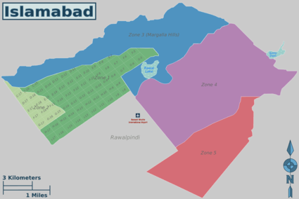
Islamabad is subdivided into five zones:[5][6]
- Zone I: Designated for urban development and federal government institutions
- Zone II: Designated for urban development
- Zone III: Designated for rural development
- Zone IV: Designated for rural development
- Zone V: Designated for rural development
Sectors
Union Councils
Islamabad Capital Territory comprises urban and rural areas. The rural consists of 23 union councils, comprising 133 villages, while urban has 27 union councils.[7]
| UC # | Chief locality | Localities within jurisdiction |
|---|---|---|
| 1 | Said Pur | Said Pur, Gokina, Talhar |
| 2 | Noorpur Shahan | Noorpur Shahan, Ratta Hutar |
| 3 | Mal Pur | Mal Pur, Romali, Nariyas, Phadu, Shahdrah Khurd, Shahdrah Kalan, Mandala, Jang Begial, Subban Syedan, Mangial, Quaid-e-Azam University |
| 4 | Kot Hathial (Shamal) | Kot Hathial, Bhara Kahu, Nayiabadi, Muhallah Alnoor, Muhallah Ban, Muhallah Malkan, Dhok Syedan |
| 5 | Kot Hathial (Janoob) | Kot Hathial, Nainsukh, Barakahu, Behra Syedan, Muhallah Ghousia, Sharak-e-Madina, Dhok Jilani, Muhallah Malikabad |
| 6 | Phulgran | Phulgran, Phul Garan, Dhok Kuch, Abbasiabad, Dhok Badhan, Muhallah Kangar, Mahallah Ranjpuran, Shahpur, Bobry, Karlot Chattar, Mohra Rajpoota, Muhallah Sumbul, Bani Gala |
| 7 | Pind Begwal | Pind Begwal, Bainala, Maira Biguwal, Atthal, Dhok Sajjal, Dhok Nanda Sihali, Jandala, Simli |
| 8 | Tumair | Tumair, Pihont, Chakhtan, Darkalam, Kanjnah |
| 9 | Charah | Charah, Dhok Maira, Dhok Las, Kiani, Dhok Haveli |
| 10 | Kirpa | Kirpa, Ladhiot Syedan, Pind Malikan, Dhok Ban, Bhimbar Tarar, Mahallah Haveli Rajgan, Mehfozabad, Chaniol, Muhallah Chaudrian, Ara, Gora Mast, Dhok Jogian Harnu, Chauntra Sogran |
| 11 | Mughal | Mughal, Hardoghar, Kangota Gujjran Sihala, Hondamial, Nara Syedan, Chuchkal Chakiyan, Chak Kamdar |
| 12 | Rawat | Rawat, Bhangrial Kalan, Banni Saran, Mohra Nagial, Sawan |
| 13 | Humak | Humak, Kaniyal, Gora Syedan, Niazian |
| 14 | Sihala | Sihala Khurd, Maira Dakhli, Bhandar Sihala, Jarki Sihala, Gagri Sihala, Jhundla, Kangota Syedan, Gura Mistriyan |
| 15 | Lohi Bhair | Lohi Bhar, Shahrak-e-Korang, Bagh-e-Sawan, Shahrak-e-Pakistan |
| 16 | Darwala | Darwala, Dhaliala, Panwal, Chucha Sheikhiyan, Bhair, Kanghar, Sher Ghamial, Dhok Kavgar, Kathrial, Chucha, Dhok Kashimiriya , Harn maira , Malali , Bun koutha, Pahg Panwal, Farash , Bangiyal |
| 17 | Koral | Koral, Tarlai Khurd, Gangal, Chaklala, Shareefabad, Gohra Sardar, Tarlai |
| 18 | Khana Dak | Khana Dak, Dhok Jabba, Pindorian, Shahrak-e-Bilal, Shahrak-e-Barma, Shahrak-e-Madina, Muhallah Wahid Abad, Shahrak-e-Masih) |
| 19 | Tarlai Kalan | Tarlai Kalan, Irfanabad, Chappar Meer Khanal, Sahana |
| 20 | Ali Pur | Ali Pur, Alipur,Jhang Syedan,Partal, Khadrapar, Farash, |
| 21 | Sohan | Sohan Dehati, Khana Kak, Shakrial, Shakrial (Sharki) |
| 22 | Chak Shahzad | Chak Shahzad, Chak Bihra Shigh, Jaba Teli, Sohana, Pandori, Chhatta Bakhtawar, Bohan, Dhoke Sharaf, Mujuhan |
| 23 | Kuri | Kuri, Malot, Rakh Bani Gala, Rihara, Mohra Jujan |
| 24 | Shahrak-e-Rawal | Shahrak-e-Rawal, Shahrak-e-Margala, Sumbal Korakh, Puna Faqeeran, Mohrian |
| 25 | Sector F-6 | F-6/1, F-6/2, F-6/3, F-6/4, Farooqi Bazar, Madni Masjid, Dhobi Gat |
| 26 | Sector G-6/1 | |
| 27 | Sector G-6 | Sector G-6/2, Sector G-6/3 & Sector G-6/4 |
| 28 | Sector F-7, F-8, F-9 | |
| 29 | Sector F-10, F-11 | |
| 30 | Sector G-7/3, G-7/4 | |
| 31 | Sector G-7/1, G-7/2 | |
| 32 | Sector G-8/3, G-8/4 | |
| 33 | Sector G-8/1, G-8/2 | |
| 34 | Sector G-9 | Sector G-9/1, G-9/3, G-9/4 |
| 35 | Sector G-9/2 | |
| 36 | Sector G-10/3, G-10/4 | |
| 37 | Sector G-10/1, G-10/2 | |
| 38 | Sector G-11 | Sector G-11/1, G-11/2, G-11/3, G-11/4 |
| 39 | Maira Sumbal Jaffar | Maira Sumbal Jaffar, Golra Sharif, Badia Rusmat Khan, Maira Akku, Dhareek Mohri, Shahrak-e-Effaq |
| 40 | Sector I-8 | Sector I-8/1,I8/2,I8/3,I8/4 |
| 41 | Sector I-9 | |
| 42 | Sector I-10/1 | |
| 43 | Sector I-10 | Sector I-10/2, I-10/3, I-10/4 |
| 44 | Bokra | Bokra, Haji Complex, Soria Harboza, Mouza Sorain, Peer Wadhai, Shahrak-e-Iqbal |
| 45 | Jhangi Saydan | |
| 46 | Village Noon | Badhana Kalan , Dhoke Makhan, ETC |
| 47 | Tarno | |
| 48 | Sarai Kharbooza | |
| 49 | Shah Allah Ditta | |
| 50 | Golra Sharif |
Climate
The climate of Islamabad has a humid subtropical climate (Köppen: Cwa), with five seasons: Winter (November–February), Spring (March and April), Summer (May and June), Rainy Monsoon (July and August) and Autumn (September and October). The hottest month is June, where average highs routinely exceed 38 °C (100.4 °F). Wettest month is July, with heavy rainfalls and evening thunderstorms with the possibility of cloudburst and flooding. Coolest month is January. Islamabad's micro-climate is regulated by three artificial reservoirs: Rawal, Simli, and Khanpur Dam. Last one is located on the Haro River near the town of Khanpur, about 40 kilometres (25 mi) from Islamabad. Simli Dam is 30 kilometres (19 mi) north of Islamabad. 220 acres (89 ha) of the city consists of Margalla Hills National Park. Loi Bher Forest is situated along the Islamabad Highway, covering an area of 1,087 acres (440 ha).[8] Highest monthly rainfall of 743.3 millimetres (29.26 in) was recorded during July 1995.[9] Winters generally feature dense fog in the mornings and sunny afternoons. In the city, temperatures stay mild, with snowfall over the higher elevations points on nearby hill stations, notably Murree and Nathia Gali. The temperatures range from 13 °C (55 °F) in January to 38 °C (100 °F) in June. The highest recorded temperature was 46.6 °C (115.9 °F) on 23 June 2005 while the lowest temperature was −6 °C (21.2 °F) on 17 January 1967.[10][11] The city has "recorded" snowfall. On 23 July 2001, Islamabad received a record breaking 620 millimetres (24 in) of rainfall in just 10 hours. It was the heaviest rainfall in Islamabad in the past 100 years and the highest rainfall in 24 hours as well.[12][13]
| Climate data for Islamabad (1961–1990) | |||||||||||||
|---|---|---|---|---|---|---|---|---|---|---|---|---|---|
| Month | Jan | Feb | Mar | Apr | May | Jun | Jul | Aug | Sep | Oct | Nov | Dec | Year |
| Record high °C (°F) | 30.1 (86.2) |
30.0 (86.0) |
34.4 (93.9) |
40.6 (105.1) |
45.6 (114.1) |
46.6 (115.9) |
45.0 (113.0) |
42.0 (107.6) |
38.1 (100.6) |
37.8 (100.0) |
32.2 (90.0) |
28.3 (82.9) |
46.6 (115.9) |
| Average high °C (°F) | 17.7 (63.9) |
19.1 (66.4) |
23.9 (75.0) |
30.1 (86.2) |
35.3 (95.5) |
38.7 (101.7) |
35.0 (95.0) |
33.4 (92.1) |
33.5 (92.3) |
30.9 (87.6) |
25.4 (77.7) |
19.7 (67.5) |
28.6 (83.5) |
| Daily mean °C (°F) | 10.1 (50.2) |
12.1 (53.8) |
16.9 (62.4) |
22.6 (72.7) |
27.5 (81.5) |
31.2 (88.2) |
29.7 (85.5) |
28.5 (83.3) |
27.0 (80.6) |
22.4 (72.3) |
16.5 (61.7) |
11.6 (52.9) |
21.3 (70.3) |
| Average low °C (°F) | 2.6 (36.7) |
5.1 (41.2) |
9.9 (49.8) |
15.0 (59.0) |
19.7 (67.5) |
23.7 (74.7) |
24.3 (75.7) |
23.5 (74.3) |
20.6 (69.1) |
13.9 (57.0) |
7.5 (45.5) |
3.4 (38.1) |
14.1 (57.4) |
| Record low °C (°F) | −6.1 (21.0) |
−2.2 (28.0) |
−0.3 (31.5) |
5.1 (41.2) |
10.5 (50.9) |
15.0 (59.0) |
17.8 (64.0) |
17.0 (62.6) |
13.3 (55.9) |
5.7 (42.3) |
−0.6 (30.9) |
−4.1 (24.6) |
−6.1 (21.0) |
| Average precipitation mm (inches) | 56.1 (2.21) |
73.5 (2.89) |
89.8 (3.54) |
61.8 (2.43) |
39.2 (1.54) |
62.2 (2.45) |
368.0 (14.49) |
334.5 (13.17) |
98.2 (3.87) |
29.3 (1.15) |
17.8 (0.70) |
37.3 (1.47) |
1,267.7 (49.91) |
| Mean monthly sunshine hours | 195.7 | 187.1 | 202.3 | 252.4 | 311.9 | 300.1 | 264.4 | 250.7 | 262.2 | 275.5 | 247.9 | 195.6 | 2,945.8 |
| Source 1: NOAA (normals)[14] | |||||||||||||
| Source 2: PMD (extremes)[15] | |||||||||||||
Cityscape
Civic administration
The main administrative authority of the city is Islamabad Capital Territory Administration with some help from Metropolitan Corporation Islamabad and Capital Development Authority (CDA), which oversees the planning, development, construction, and administration of the city. Islamabad Capital Territory is divided into eight zones: Administrative Zone, Commercial District, Educational Sector, Industrial Sector, Diplomatic Enclave, Residential Areas, Rural Areas and Green Area.
Islamabad city is divided into five major zones: Zone I, Zone II, Zone III, Zone IV, and Zone V. Out of these, Zone IV is the largest in area. All sectors of ghouri town (1, 2, 3, VIP, 5, 4-A, 4-B, 4-C, 5-A, 5-B and sector 7) are located in this zone. Zone I consists mainly of all the developed residential sectors, while Zone II consists of the under-developed residential sectors. Each residential sector is identified by a letter of the alphabet and a number, and covers an area of approximately 4 square kilometres. The sectors are lettered from A to I, and each sector is divided into four numbered sub-sectors.[16]
Series A, B, and C are still underdeveloped. The D series has seven sectors (D-11 to D-17), of which only sector D-12 is completely developed. This series is located at the foot of Margalla Hills.[17] The E Sectors are named from E-7 to E-17. Many foreigners and diplomatic personnel are housed in these sectors.[17] In the revised Master Plan of the city, CDA has decided to develop a park on the pattern of Fatima Jinnah Park in sector E-14. Sectors E-8 and E-9 contain the campuses of Bahria University, Air University, and the National Defence University.[18][19][20] The F and G series contains the most developed sectors. F series contains sectors F-5 to F-17; some sectors are still under-developed. F-5 is an important sector for the software industry in Islamabad, as the two software technology parks are located here. The entire F-9 sector is covered with Fatima Jinnah Park. The Centaurus complex will be one of the major landmarks of the F-8 sector.[17] G sectors are numbered G-5 through G-17. Some important places include the Jinnah Convention Center and Serena Hotel in G-5, the Red Mosque in G-6, and the Pakistan Institute of Medical Sciences, the largest medical complex in the capital, located in G-8.[17]
The H sectors are numbered H-8 through H-17. The H sectors are mostly dedicated to educational and health institutions. National University of Sciences and Technology covers a major portion of sector H-12.[17] The I sectors are numbered from I-8 to I-18. With the exception of I-8, which is a well-developed residential area, these sectors are primarily part of the industrial zone. Currently two sub-sectors of I-9 and one sub-sector of I-10 are used as industrial areas. CDA is planning to set up Islamabad Railway Station in Sector I-18 and Industrial City in sector I-17.[17] Zone III consists primarily of the Margalla Hills and Margalla Hills National Park. Rawal Lake is in this zone. Zone IV and V consist of Islamabad Park, and rural areas of the city. The Soan River flows into the city through Zone V.
Demographics
While urban Islamabad is home to people from all over Pakistan as well as expatriates, in the rural areas a number of Pothohari speaking tribal communities can still be recognised.[22]
Islamabad-Rawalpindi metropolitan area
When the master plan for Islamabad was drawn up in 1960, Islamabad and Rawalpindi, along with the adjoining areas, was to be integrated to form a large metropolitan area called Islamabad/Rawalpindi Metropolitan Area. The area would consist of the developing Islamabad, the old colonial cantonment city of Rawalpindi, and Margalla Hills National Park, including surrounding rural areas.[23][24] However, Islamabad city is part of the Islamabad Capital Territory, while Rawalpindi is part of Rawalpindi District, which is part of province of Punjab.[25]
Initially, it was proposed that the three areas would be connected by four major highways: Murree Highway, Islamabad Highway, Soan Highway, and Capital Highway. However, to date only two highways have been constructed: Kashmir Highway (the former Murree Highway) and Islamabad Highway.[24] Plans of constructing Margalla Avenue are also underway.[26] Islamabad is the hub all the governmental activities while Rawalpindi is the centre of all industrial, commercial, and military activities. The two cities are considered sister cities and are highly interdependent.[23]
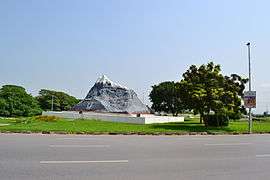 Chaghi Monument
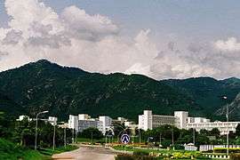 Pakistan Secretariat
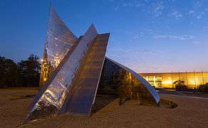 Star and Crescent Monument near the start of Shakarparian
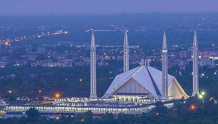
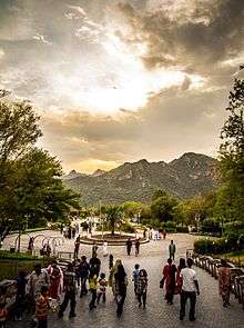 Daman-e-Koh Park
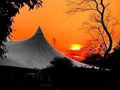 Sunset over the Lake View Park
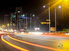 view of Blue Area, the commercial hub of the city.
Economy
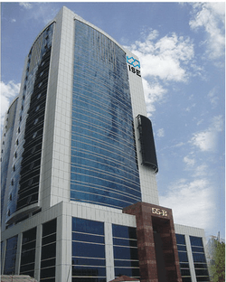
Islamabad is a net contributor to the Pakistani economy, as whilst having only 0.8% of the country's population, it contributes 1% to the country's GDP.[27] Islamabad Stock Exchange, founded in 1989, is Pakistan's third largest stock exchange after Karachi Stock Exchange and Lahore Stock Exchange.[28] The exchange has 118 members with 104 corporate bodies and 18 individual members. The average daily turnover of the stock exchange is over 1 million shares.[29] As of 2012, Islamabad LTU (Large Tax Unit) was responsible for Rs 371 billion in tax revenue, which amounts to 20% of all the revenue collected by Federal Board of Revenue.[30]
Islamabad has seen an expansion in information and communications technology with the addition two Software Technology Parks, which house numerous national and foreign technological and information technology companies. The tech parks are located in Evacuee Trust Complex and Awami Markaz. Awami Markaz houses 36 IT companies while Evacuee Trust house 29 companies.[31] Call centres for foreign companies have been targeted as another significant area of growth, with the government making efforts to reduce taxes by as much as 10% to encourage foreign investments in the information technology sector. Most of Pakistan's state-owned companies like PIA, PTV, PTCL, OGDCL, and Zarai Taraqiati Bank Ltd. are based in Islamabad. Headquarters of all major telecommunication operators such as PTCL, Mobilink, Telenor, Ufone, and China Mobile are located in Islamabad. Being an expensive city, the prices of most of fruits, vegetable and poultry items increased in Islamabad during the year 2015-2020[32]
Tourism
Transport
Islamabad is connected to major destinations around the world through Islamabad International Airport. The airport is the largest in Pakistan, handling 9 million passengers per annum. The airport was built at a cost of $400 million and opened on May 3, 2018, replacing the former Benazir Bhutto International Airport. It is the first greenfield airport in Pakistan with an area of 3,600-acre (15 km2).[33]
The Rawalpindi-Islamabad Metrobus is a 24 km (14.9 mi) bus rapid transit system that serves the twin cities of Rawalpindi and Islamabad in Pakistan. It uses dedicated bus lanes for all of its route covering 24 bus stations. Islamabad is well connected with other parts of the country through car rental services such as Alvi Transport Network and Pakistan Car Rentals.
All major cities and towns are accessible through regular trains and bus services running mostly from the neighbouring city of Rawalpindi. Lahore and Peshawar are linked to Islamabad through a network of motorways, which has significantly reduced travelling times between these cities. M-2 Motorway is 367 km (228 mi) long and connect Islamabad and Lahore.[34] M-1 Motorway connects Islamabad with Peshawar and is 155 km (96 mi) long.[34] Islamabad is linked to Rawalpindi through the Faizabad Interchange, which has a daily traffic volume of about 48,000 vehicles.[35]
Education
Islamabad has the highest literacy rate of Pakistan at 95%.[36] Islamabad also has some of Pakistan's major universities, including Quaid-i-Azam University, the International Islamic University, and the National University of Sciences and Technology and Pakistan Institute of Engineering and Applied Sciences
Private School Network Islamabad is working for private educational institutions. The president of PSN is Dr. Muhammad Afzal Babur from Bhara Kahu. PSN is divided into eight zones in Islamabad. In Tarlai Zone Chaudhary Faisal Ali from Faisal Academy Tarlai Kalan is Zonal General Sectary of PSN.
Quaid-e-Azam University has several faculties. The institute is located in a semi-hilly area, east of the Secretariat buildings and near the base of Margalla Hills. This Post-Graduate institute is spread over 1,705 acres (6.90 km2). The nucleus of the campus has been designed as an axial spine with a library as its center. Other universities include the following:[37]
- Bahria University
- Air University
- Quaid-e-Azam University
- Allama Iqbal Open University (AIOU)
- Alkauthar Islamic University
- COMSATS Institute of Information Technology (CIIT)
- Capital University of Science and Technology (CUST) [Formally Mohammad Ali Jinnah University, Islamabad Campus]
- Federal Urdu University of Arts, Science & Technology (FUUAST)
- National University of Sciences and Technology (NUST)
- National Defense University, Islamabad(NDU)
- National University of Modern Languages (NUML)
- Institute of Space Technology
- International Islamic University Islamabad
- Institute of Cost and Management Accountants of Pakistan (ICMAP)
- Pakistan Institute of Development Economics (PIDE)
- Pakistan Institute of Engineering and Applied Sciences (PIEAS)
- Shifa College of Medicine
- Foundation University Islamabad (FUI)
- National University of Computer & Emerging Sciences(FAST-NUCES)
- Riphah International University
- University of Lahore
- Center for Advanced Studies in Engineering
- Preston University Islamabad Campus
- Iqra University Islamabad Campus
- Shaheed Zulfiqar Ali Bhutto Institute of Science and Technology (ZABIST)
- Hamdard University Islamabad Campus
- The Millennium Universal College Islamabad Campus
Sports
Islamabad United became the first ever team to win Pakistan Super League in 2016.[38] And now the federal team Is participating in the Pakistan Cup. The team is under the captaincy of Misbah-ul-Haq, former captain of Pakistan, The Islamabad United was also under Misbah.
See also
- Islamabad Capital Territory Administration
- List of cultural heritage sites in Islamabad Capital Territory
- Developments in Islamabad
- Model Town Humak
References
- Berenson, Alex (2011). The Midnight House. Random House. p. 5. ISBN 978-0099536970.
- "The News International: Latest News Breaking, Pakistan News". thenews.com.pk. Retrieved 24 February 2016.
- District Profile: Central Punjab - Islamabad
- Vinayak Bharne, ed. (2013). The Emerging Asian City: Concomitant Urbanities and Urbanisms. Routledge. p. 131. ISBN 978-0-415-52597-8.
- "Federal Territory". HIKEPK. Retrieved 3 February 2019.
- "Capital Development Authority". www.cda.gov.pk. Retrieved 21 May 2019.
- Islamabad Capital Territory Administration Archived 4 April 2011 at the Wayback Machine. Ictadministration.gov.pk. Retrieved on 12 July 2013.
- "Urban growth monitoring along Islamabad Highway". GIS Development.
- "Climate Records: Islamabad". Archived from the original on 12 January 2012. Retrieved 14 January 2012.
- "Internet Archive Wayback Machine". 13 June 2010. Archived from the original on 13 June 2010. Retrieved 15 January 2012.
- "Average Conditions, Islamabad, Pakistan". Retrieved 25 September 2009.
- "Severe Storms on dated 23rd July 2001 Islamabad, Pakistan" (PDF). Abdul Hameed, Director Pakistan Meteorological Department.
- "Weather Log – July 21–31, 2001". National Climatic Data Center. 6 August 2001.
- "Islamabad Climate Normals 1961-1990". National Oceanic and Atmospheric Administration. Retrieved 16 January 2012.
- "Extremes of Islamabad". Pakistan Meteorological Department. Retrieved 1 February 2015.
- Matthew S. Hull (5 June 2012). Government of Paper: The Materiality of Bureaucracy in Urban Pakistan (1st ed.). University of California Press. p. 50. ISBN 978-0520272156. Retrieved 4 July 2012.
- "The Idea of Islamabad". TheIslamabad.com. Archived from the original on 10 September 2009. Retrieved 10 October 2015.
- Bahria University. "Official website". Archived from the original on 1 March 2010.
- Air University. "Official website".
- National Defence University. "Official website".
- "CCI defers approval of census results until elections". Retrieved 2 April 2020.
- A Gazetteer of Rawalpindi District Part A 1907
- Dulyapak Preecharushh (6 April 2011). "Myanmar's New Capital City of Naypyidaw". In Stanley D. Brunn (ed.). Engineering Earth: The Impacts of Megaengineering Projects (1st ed.). Springer. p. 1041. ISBN 978-9048199198. Retrieved 4 July 2012.
- Muhammad. "Planning of Islamabad and Rawalpindi" (PDF).
- Sheikh, Iqbal M.; Van S. Williams; S. Qamer Raza; Kanwar S.A. Khan. "Environmental Geology of the Islamabad-Rawalpindi Area, Northern Pakistan" (PDF). Regional Studies of the Potwar Plateau Area, Northern Pakistan. U.S. Department of the Interior, U.S. Geological Survey.
- "Margalla Avenue to benefit commuters of KPK, traffic on Kashmir Highway". OnePakistan. Archived from the original on 4 March 2016. Retrieved 7 October 2013.
- "Pakistan | Economics and extremism". Dawn. 5 January 2010. Archived from the original on 8 January 2010. Retrieved 2 June 2010.
- "Pakistan Stock Exchanges". Archived from the original on 28 February 2010. Retrieved 10 October 2015.
- ISE-Official website. "About ISE". Archived from the original on 17 June 2011.
- "Rs 371bn revenue target: FBR hails LTU Islamabad's performance". Business Recorder. 5 July 2012. Retrieved 9 July 2012.
- Pakistan Software Export Board. "Islamabad". Archived from the original on 5 May 2010.
- "Retail Prices of Vegetables, Fruits and Poultry in Islamabad from 2015-2020". Deliver It - Online Grocery Store in Islamabad.
- CPG Corporation. "New Islamabad International Airport's Passenger Terminal Building". Archived from the original on 21 November 2007.
- National Highway Authority Pakistan. "Motorway's of Pakistan".
- NESPAK. "Faizabad Interchange". Archived from the original on 10 August 2011.
- "LITERACY-POPULATION 10 YEARS AND OLDER" (PDF). Archived from the original (PDF) on 13 November 2010. Retrieved 28 September 2010.
- HEC recognized Universities Archived 29 October 2013 at the Wayback Machine. Hec.gov.pk. Retrieved on 12 July 2013.
- "ARY Digital Network President Salman Iqbal congratulates Islamabad United over winning PSL". arynews.tv. 24 February 2016. Retrieved 24 February 2016.
External links
![]()

| Provinces | ||
|---|---|---|
| Territories | ||
| Autonomous regions | ||
See also: Former administrative units of Pakistan | ||