Iowa Territory
The Territory of Iowa was an organized incorporated territory of the United States that existed from July 4, 1838, until December 28, 1846, when the southeastern portion of the territory was admitted to the Union as the state of Iowa. The remainder of the territory would have no organized territorial government until the Minnesota Territory was organized on March 3, 1849.
| Territory of Iowa | |||||||||
|---|---|---|---|---|---|---|---|---|---|
| Organized incorporated territory of the United States | |||||||||
| 1838–1846 | |||||||||
 The territory that did not become the state of Iowa in 1846 became unorganized territory. The government for this area would become organized as part of the Minnesota Territory in 1849. | |||||||||
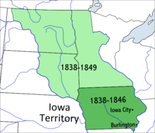
| Capital | Burlington (1838–1841) Iowa City (1841–1849) | ||||||||
| Government | |||||||||
| • Type | Organized incorporated territory | ||||||||
| Governor | |||||||||
• 1838–1841 | Robert Lucas | ||||||||
• 1841–1845 | John Chambers | ||||||||
• 1845–1849 | James Clarke | ||||||||
| History | |||||||||
• Organized from Wisconsin Territory | July 4 1838 | ||||||||
| December 28 1846 | |||||||||
| |||||||||
History
Most of the area in the territory was originally part of the Louisiana Purchase and was a part of the Missouri Territory. When Missouri became a state in 1821, this area (along with the Dakotas) effectively became unorganized territory. The area was closed to white settlers until the 1830s, after the Black Hawk War ended. It was attached to the Michigan Territory on June 28, 1834. At an extra session of the Sixth Legislative Assembly of Michigan held in September, 1834, the Iowa District was divided into two counties by running a line due west from the lower end of Rock Island in the Mississippi River. The territory north of this line (which started just south of the present-day Davenport) was named Dubuque County, and all south of it was Des Moines County. When Michigan became a state in 1836 the area became the Iowa District of western Wisconsin Territory—the region west of the Mississippi River.
The original boundaries of the territory, as established in 1838, included Minnesota and parts of the Dakotas, covering about 194,000 square miles (500,000 km2) of land.
Burlington was the stop-gap capital; Iowa City was designated as the official territorial capital in 1841.[1]
When Iowa became a state on December 28, 1846, no provision was made for official organization of the remainder of the territory.[2] Morgan L. Martin, the Wisconsin territorial delegate to congress, pushed through a bill to organize a territory of Minnesota which would encompass this land. While the bill passed in the house, it did not pass the senate. In the following session a bill by Stephen A. Douglas was introduced in the senate but also did not pass. The situation was resolved when Minnesota Territory was organized on March 3, 1849, the day before the close of congress.[3]
Governance
| Year | Pop. | ±% |
|---|---|---|
| 1840 | 43,112 | — |
| Source: 1840;[4] | ||
Territorial officers of Iowa Territory from 1838–1846.[5]
Governors
- Robert Lucas, appointed 1838.
- John Chambers, appointed 1841.
- James Clarke, appointed 1845.
Secretaries
- William B. Conway, appointed 1838; died in office, November 1839.
- James Clarke, appointed 1839.
- O. H. W. Stull, appointed 1841.
- Samuel J. Burr, appointed 1843.
- Jesse Williams, appointed 1845.
Auditors
- Jesse Williams, appointed 1840.
- William L. Gilbert, appointed 1843.
- Robert M. Secrest, appointed 1845.
Treasurers
- Thornton Bayless, appointed 1839.
- Morgan Reno, appointed 1840.
Congressional delegates
- William W. Chapman 25th and 26th Congresses, 1838–1840
- Francis Gehon, irregularly "elected" in 1839, but never served as delegate
- Augustus C. Dodge, in the 27th, 28th, and 29th Congresses, 1840–1846
See also
| Wikisource has original text related to this article: |
References
- "HOW IOWA BECAME A TERRITORY". iagenweb.org.
- "Chapter 2 — Founding Documents" (PDF). 2013 - 2014 Minnesota Legislative Manual (Blue Book) (PDF). Saint Paul, MN: Office of the Minnesota Secretary of State. 2013. p. 50. Retrieved August 19, 2014.
- Shortridge, Wilson P. (August 1919). "Henry Hastings Sibley and the Minnesota Frontier". Minnesota History Bulletin. 3 (3): 115–125. Retrieved August 19, 2014.
- Forstall, Richard L. (ed.). Population of the States and Counties of the United States: 1790–1990 (PDF) (Report). United States Census Bureau. p. 4. Retrieved May 18, 2020.
- "IAGenWeb Project". Retrieved August 2, 2018.
| |
| |
| |
| |
|