Inverkip railway station
Inverkip railway station is a railway station serving the village of Inverkip, Inverclyde, Scotland. The station is managed by Abellio ScotRail and is on the Inverclyde Line, 28¾ miles (46 km) west of Glasgow Central.
| Inverkip | |
|---|---|
| Scottish Gaelic: Inbhir Chip[1] | |
 Inverkip railway station | |
| Location | |
| Place | Inverkip |
| Local authority | Inverclyde |
| Coordinates | 55.9060°N 4.8724°W |
| Grid reference | NS205718 |
| Operations | |
| Station code | INP |
| Managed by | Abellio ScotRail |
| Number of platforms | 1 |
| Live arrivals/departures, station information and onward connections from National Rail Enquiries | |
| Annual rail passenger usage* | |
| 2014/15 | |
| 2015/16 | |
| 2016/17 | |
| 2017/18 | |
| 2018/19 | |
| National Rail – UK railway stations | |
| * Annual estimated passenger usage based on sales of tickets in stated financial year(s) which end or originate at Inverkip from Office of Rail and Road statistics. Methodology may vary year on year. | |
The embankment is all that remains of the former Down platform. All of the station buildings have now been removed and replaced with a bus shelter. The flats at the station (known as The Kyles) are built in what was the station goods yard. There was also a coal yard located in this area. Inverkip also had its own signal box, located at the end of the down platform. A camping coach was positioned here by the Scottish Region from 1959 to 1969, from 1963 it was a Pullman camping coach.[2] At the further end of the yard area, where the housing development is located, are the parapets of a metal overbridge, presumably used to move goods across from the up platform.
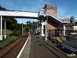
The station, built in 1865, was substantially modified in 2012 to accommodate the erection of a footbridge with an integrated lift. This structure was required as a planning permission clause related to the construction of a new housing estate in the fields across the line from the station. It was not possible to fit a ramped bridge in the available space, hence the need for a lift, making Inverkip one of the few unmanned stations in Scotland to have a lift (other examples can be found at Prestwick International Airport and Edinburgh Park). The shelter was replaced and relocated further west and the steps from station Avenue were relocated slightly further east. Temporary steps were put in place during the year-long construction project. The lift serves the platform level and the footbridge level. Strangely, it is necessary to exit the station in order to access the steps to the footbridge since there are no steps directly from the platform to the bridge. There are no steps to the bridge on the other side of the line due to the steep embankment there.
Groundworks for the footbridge started in 2011, with the main span being lifted into place in the early hours of 15 July 2012. The bridge was formally opened in December 2012. A Park & Ride car park with 26 spaces was also opened across the line from the station at that time.
Services
The station is served mainly by Class 380s with Class 314s also used to cover peak periods. Class 320s were used occasionally during the winter of 2016/17.
There is an hourly service daily (including Sundays) from Inverkip, westbound to Wemyss Bay and eastbound to Glasgow Central via Paisley Gilmour Street.[3]
| Preceding station | Following station | |||
|---|---|---|---|---|
| Wemyss Bay | Abellio ScotRail Inverclyde Line |
Branchton | ||
| Historical railways | ||||
| Wemyss Bay Line and station open |
Caledonian Railway Greenock and Wemyss Bay Railway |
Ravenscraig Line open; station closed | ||
| Wemyss Bay | Abellio ScotRail Inverclyde Line |
IBM | ||
Gallery
 The western end of the tunnels which run beneath the steeply sloped Commoncraig. The tunnel on the right has been out of use since electrification of the Wemyss Bay line in 1966.
.jpg) This was once a fairly grand station with two platforms, substantial buildings and a goods yard. It is now reduced to one platform with bus shelter. Dunrod Hill is visible in the distance, beyond the trees.
This was once a fairly grand station with two platforms, substantial buildings and a goods yard. It is now reduced to one platform with bus shelter. Dunrod Hill is visible in the distance, beyond the trees.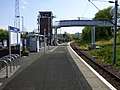 View past the footbridge towards the former IBM Halt station.
 The lift at footbridge deck level.
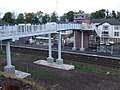 Looking across the line to the station from Lochans Drive.
References
- Brailsford, Martyn, ed. (December 2017) [1987]. "Gaelic/English Station Index". Railway Track Diagrams 1: Scotland & Isle of Man (6th ed.). Frome: Trackmaps. ISBN 978-0-9549866-9-8.CS1 maint: ref=harv (link)
- McRae, Andrew (1998). British Railways Camping Coach Holidays: A Tour of Britain in the 1950s and 1960s. Scenes from the Past: 30 (Part Two). Foxline. p. 13. ISBN 1-870119-53-3.
- Table 219 National Rail timetable, May 2016