Inverclyde
Inverclyde (Scots: Inerclyde, Scottish Gaelic: Inbhir Chluaidh, pronounced [iɲiɾʲˈxlˠ̪uəj], "mouth of the Clyde") is one of 32 council areas used for local government in Scotland. Together with the East Renfrewshire and Renfrewshire council areas, Inverclyde forms part of the historic county of Renfrewshire, which currently exists as a registration county and lieutenancy area - located in the west central Lowlands. It borders the North Ayrshire and Renfrewshire council areas, and is otherwise surrounded by the Firth of Clyde.
Inverclyde Inerclyde Inbhir Chluaidh | |
|---|---|
 | |
 Coat of arms | |
| Coordinates: 55°54′N 4°45′W | |
| Sovereign state | United Kingdom |
| Country | Scotland |
| Lieutenancy area | Renfrewshire |
| Admin HQ | Greenock |
| Government | |
| • Body | Inverclyde Council |
| • Control | Labour minority (council NOC) |
| • MPs | |
| • MSPs | |
| Area | |
| • Total | 62.0 sq mi (160.5 km2) |
| Area rank | Ranked 29th |
| Population (mid-2019 est.) | |
| • Total | 78,150 |
| • Rank | Ranked 28th |
| • Density | 1,300/sq mi (490/km2) |
| ONS code | S12000018 |
| ISO 3166 code | GB-IVC |
| Website | www |
Inverclyde was formerly one of nineteen districts within Strathclyde Region, from 1975 until 1996. Prior to 1975, Inverclyde was governed as part of the local government county of Renfrewshire, comprising the burghs of Greenock, Port Glasgow and Gourock, and the former fifth district of the county. Its landward area is bordered by the Kelly, North and South Routen burns to the southwest (separating Wemyss Bay and Skelmorlie, North Ayrshire), part of the River Gryfe and the Finlaystone Burn to the south-east.
It is one of the smallest in terms of area (29th) and population (28th) out of the 32 Scottish unitary authorities. Along with the council areas clustered around Glasgow it is considered part of Greater Glasgow in some definitions,[1] although it is physically separated from the city area by open countryside and does not share a border with the city.
The name derives from the extinct barony of Inverclyde (1897) conferred upon Sir John Burns of Wemyss Bay and his heirs.
Towns and villages
| Name | Population (2001 census) |
|---|---|
| Gourock | 11,511 |
| Greenock | 45,467 |
| Inverkip | 1,598 |
| Kilmacolm | 4,000 |
| Port Glasgow | 16,617 |
| Quarrier's Village | > 999 ‡ |
| Wemyss Bay | 2,466 |
‡ Taken from Inverclyde Ward 1 figure, minus Kilmacolm settlement population.
Council
Until 2006, Inverclyde was the only authority in the United Kingdom not to have named electoral wards: whilst the local authority reserved its right to name wards, it failed to supply any to the Local Government Boundary Commission. This was rectified in the 2006 review; however, the six multi-member wards created for the 2007 elections used only vague geographical descriptions ('Inverclyde North', 'Inverclyde East', 'Inverclyde South West' etc), in contrast to the majority of names for such wards introduced at the same time across the country.
Composition
Following the Council elections of 2017 the current composition of Inverclyde Council is:
| Party | Members | |
|---|---|---|
| Labour | 8 | |
| SNP | 7 | |
| Independent | 4 | |
| Conservative | 2 | |
| Liberal Democrats | 1 | |
The election resulted in no overall control of the council.
Wards
Six multi-member wards (20 seats) were created for the 2007 election, replacing 20 single-member wards which had been in place since the 1980s. The representation was increased to 22 councillors across 7 seats for the 2017 election:
- Inverclyde East - 3 seats (primarily Kilmacolm plus eastern Port Glasgow)
- Inverclyde East Central - 3 seats (Port Glasgow)
- Inverclyde Central - 3 seats (created for 2017 election, eastern Greenock)
- Inverclyde North - 4 seats (northern Greenock)
- Inverclyde West - 3 seats (Gourock)
- Inverclyde South West - 3 seats (primarily inverkip and Wemyss Bay plus south-western Greenock)
- Inverclyde South - 3 seats (southern Greenock)
Recent history

The council gained national notoriety in 2005 following harsh criticism from the Accounts Commission regarding poor leadership and accountability.[2] In November 2005 the council was given a 6-month deadline to reorganise and improve further, following the resignation of the council chief in September and organisational changes in the wake of the original report.[3]
Following this criticism, the Chief Executive of Inverclyde Council Robert Cleary stepped down and a new chief executive John Mundell was appointed. The position of Chief Executive commands an annual salary of £112,000. There was criticism over the benefits the outgoing chief executive received on leaving—he was given a six-figure severance payment and his pension will be approximately £50,000 per annum.
In June 2006, changes were still ongoing: Inverclyde Council altered its directorship structure by adding new corporate director positions and removing senior manager positions. It was expected that the £90,000 a year posts will mostly be filled by new applicants, although existing Council workers were able to apply.[4] There was some criticism with regards to the merging of council services; for instance, Education and Social Work merged and now share the same director. This was frowned upon as at the time the Director responsible for the two merged departments had an educational qualification, not a social work one.
The 2007 council elections took place at the same time as the Scottish Parliament elections. The Liberal Democrats lost nine seats; Labour gained two but fell short of a majority. The SNP and Conservatives both entered the council with five seats and one seat respectively, while an independent candidate also won a place. In 2014, one of the Labour councillors, Vaughan Jones, became an independent member after announcing support for Scottish independence.[5]
In the 2014 independence referendum, the "No" vote won in Inverclyde by just 86 votes and a margin of 0.2%. By either measure, this was the narrowest result of any of the 32 council areas. In the 2016 EU Referendum, Inverclyde posted a "Remain" vote of almost 64%.
In 2019, the Inverclyde Council Area was rated as the most deprived in Scotland by the Scottish Index of Multiple Deprivation (SIMD), with Greenock Town Centre the most deprived community. (The term "deprivation" refers not only to low income according to the BBC, but may also include "fewer resources and opportunities, for example in health and education".) After the announcement, Deputy leader Jim Clocherty said that he hoped that investment money would arrive soon, and that "no part of Scotland wants to be labelled as the 'most deprived'". A £3m investment was scheduled for Greenock Town Centre and there was also plan to create a new cruise visitor centre with other investment funds being expected.[6]
Inverclyde District
Inverclyde was one of nineteen local government districts in the Strathclyde region of Scotland, which existed between 1975 and 1996.[7] The district was formed by the Local Government (Scotland) Act 1973 from part of the county of Renfrewshire. The boundaries remain the same as those of the modern council area. The remaining parts of the County of Renfrew (Renfrewshire) were divided between two other districts: Eastwood and Renfrew District. In 1996 Inverclyde District was abolished under the provisions of the Local Government etc. (Scotland) Act 1994. Most of its area became the new Inverclyde council area, with the regions - such as Strathclyde - disappearing entirely.
Places of interest
- Ardgowan Estate
- The Bogal Stone
- Cappielow
- Castle Levan
- Clyde Muirshiel Regional Park
- Greenock Cut Visitor Centre[8]
- Custom House Quay and Museum[9]
- Duchal House
- Finlaystone House
- Gourock Outdoor Pool[10]
- Granny Kempock Stone
- Loch Thom
- Lunderston Bay[8]
- McLean Museum and Art Gallery[11]
- Newark Castle[12]
- Waterfront Leisure Complex[13]
Education
Inverclyde has twenty primary schools serving all areas of its settlements. These are:
- Aileymill Primary School, Greenock (merger of Larkfield and Ravenscraig primaries)
- All Saints Primary School, Greenock (merger of St. Kenneth's and St. Lawrence's primaries)
- Ardgowan Primary School, Greenock
- Gourock Primary School, Gourock
- Inverkip Primary School, Inverkip
- Kilmacolm Primary School, Kilmacolm/Port Glasgow
- King's Oak Primary School, Greenock (merger of King's Glen and Oakfield primaries)
- Lady Alice Primary School, Greenock
- Moorfoot Primary School, Gourock
- Newark Primary School, Port Glasgow (merger of Boglestone, Clune Park, Highholm and Slaemuir primaries)
- St. Andrew's Primary School, Greenock (merger of Sacred Heart and St. Gabriel's primaries)
- St. Francis' Primary School, Port Glasgow
- St. John's Primary School, Port Glasgow
- St. Joseph's Primary School, Greenock
- St. Mary's Primary School, Greenock
- St. Michael's Primary School, Port Glasgow
- St. Ninian's Primary School, Gourock
- St. Patrick's Primary School, Greenock
- Wemyss Bay Primary School, Wemyss Bay
- Whinhill Primary School, Greenock (merger of Highlanders' Academy and Overton primaries)
These are connected to several Secondary schools which serve Inverclyde as follows:
- Clydeview Academy, serving the West End of Greenock and the town of Gourock
- Inverclyde Academy, serving South and East Greenock as well as the villages of Inverkip and Wemyss Bay
- Notre Dame High School, serving Greenock
- Port Glasgow High School, serving Port Glasgow and Kilmacolm
- St Columba's High School, Gourock/Greenock, serving Gourock, Inverkip and Wemyss Bay
- St. Stephen's High School, serving Port Glasgow, Kilmacolm and the East End of Greenock
- Craigmarloch School which is an Additional Support Needs school for pupils aged 4-18 based at the new Port Glasgow Community Campus after the merging of Glenburn and Lilybank schools.
Demography
The average life expectancy for Inverclyde male residents (2013–2015) is 75.4 years, to rank 28th out of the 32 areas in Scotland. The average Inverclyde female lives for 80.4 years, to rank 26th out 32.[14] There are large health disparities between settlements in Inverclyde with many health indicators being above the Scottish average in certain areas, whilst considerably below in others.[15]
See also
References
- "Council urged to tackle failings". BBC News. 2 June 2005. Retrieved 8 July 2006.
- "Council given deadline to improve". BBC News. 30 November 2005. Retrieved 8 July 2006.
- "Inverclyde starts big changes at the top". The Herald. 23 June 2006. Archived from the original on 1 July 2013. Retrieved 8 July 2006.
- "Inverclyde Council leader tells of plans after councillor leaves party". Greenock Telegraph. 23 September 2014. Retrieved 18 October 2014.
- "Scotland's most and least deprived areas named". BBC News. 28 January 2020. Retrieved 28 January 2020.
- Inverclyde, Undiscovered Scotland
- http://www.clydemuirshiel.co.uk
- Archived 23 September 2006 at the Wayback Machine
- "Online Member Services". www.inverclydeleisure.com.
- "Archived copy". Archived from the original on 22 November 2005. Retrieved 1 September 2005.CS1 maint: archived copy as title (link)
- "Historic Environment Scotland". www.historic-scotland.gov.uk.
- "Online Member Services". www.inverclydeleisure.com.
- "Life expectancy for areas within Scotland 2013–2015" (PDF). National records for Scotland. Retrieved 1 January 2017.
- "Archived copy". Archived from the original on 4 April 2012. Retrieved 23 June 2011.CS1 maint: archived copy as title (link)
External links
| Wikimedia Commons has media related to Inverclyde. |
Local government areas of Scotland, in use 1973 to 1996 | ||
|---|---|---|
| Borders | 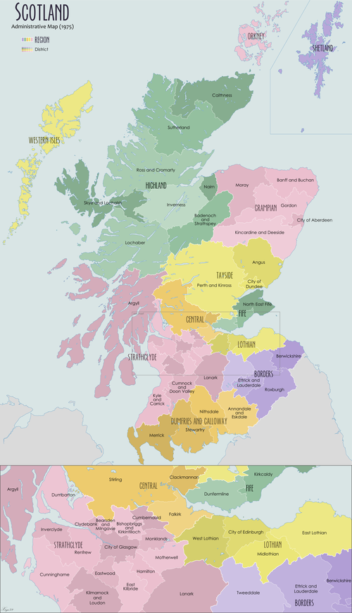 | |
| Central Region | ||
| Dumfries and Galloway | ||
| Fife | ||
| Grampian | ||
| Highland | ||
| Lothian | ||
| Strathclyde | ||
| Tayside | ||
| Island areas1 | ||