Tateyama, Chiba
Tateyama (館山市, Tateyama-shi) is a city located in Chiba Prefecture, Japan. As of 1 June 2019, the city had an estimated population of 45,432, and a population density of 413 persons per km². The total area is 110.05 square kilometres (42.49 sq mi).
Tateyama 館山市 | |
|---|---|
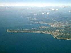 Cape Sunosaki and Tateyama City | |
 Flag  Seal | |
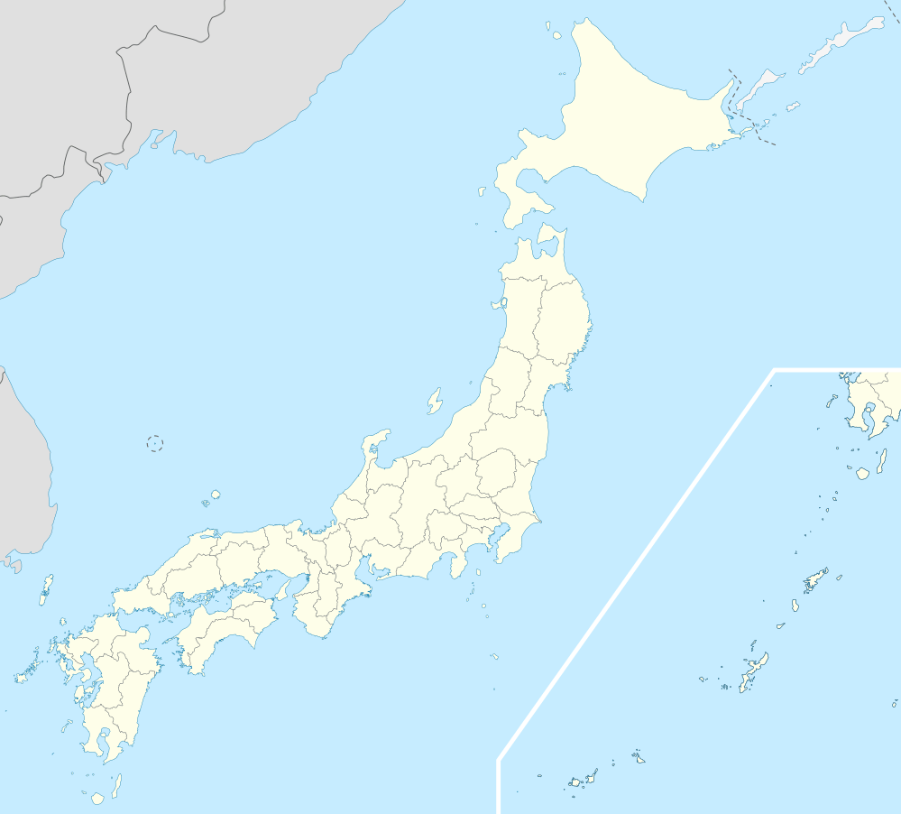
 Location of Tateyama in Chiba Prefecture | |
 Tateyama | |
| Coordinates: 34°59′47.7″N 139°52′11.9″E | |
| Country | Japan |
| Region | Kantō |
| Prefecture | Chiba Prefecture |
| Area | |
| • Total | 110.05 km2 (42.49 sq mi) |
| Population (June 1, 2019)[2] | |
| • Total | 45,432 |
| • Density | 410/km2 (1,100/sq mi) |
| Time zone | UTC+9 (Japan Standard Time) |
| - Tree | Camellia |
| Phone number | 0470-22-3111 |
| Address | 1145-1 Hōjō, Tateyama-shi, Chiba-ken 294-8601 |
| Website | http://www.city.tateyama.chiba.jp/ |
Geography
Tateyama is located at the far southern tip of the Bōsō Peninsula, facing the Pacific Ocean to the east and south, and the entrance to Tokyo Bay on the west.
Neighboring municipalities
Chiba Prefecture
- Minamibōsō
Climate
Tateyama has a humid subtropical climate (Köppen climate classification Cfa) with very warm summers and cool winters. Precipitation is significant throughout the year, but is somewhat lower in winter.
| Climate data for Tateyama, Chiba | |||||||||||||
|---|---|---|---|---|---|---|---|---|---|---|---|---|---|
| Month | Jan | Feb | Mar | Apr | May | Jun | Jul | Aug | Sep | Oct | Nov | Dec | Year |
| Average high °C (°F) | 10.9 (51.6) |
10.9 (51.6) |
13.4 (56.1) |
18.2 (64.8) |
22.1 (71.8) |
24.5 (76.1) |
27.9 (82.2) |
30.0 (86.0) |
26.9 (80.4) |
22.1 (71.8) |
17.7 (63.9) |
13.4 (56.1) |
19.8 (67.7) |
| Daily mean °C (°F) | 6.0 (42.8) |
6.4 (43.5) |
8.8 (47.8) |
13.9 (57.0) |
17.9 (64.2) |
20.9 (69.6) |
24.3 (75.7) |
25.9 (78.6) |
22.9 (73.2) |
17.5 (63.5) |
13.0 (55.4) |
8.2 (46.8) |
15.5 (59.8) |
| Average low °C (°F) | 0.6 (33.1) |
1.3 (34.3) |
3.7 (38.7) |
9.2 (48.6) |
13.6 (56.5) |
17.7 (63.9) |
21.3 (70.3) |
22.6 (72.7) |
19.5 (67.1) |
13.2 (55.8) |
8.1 (46.6) |
2.6 (36.7) |
11.1 (52.0) |
| Average precipitation mm (inches) | 83.2 (3.28) |
99.5 (3.92) |
158.3 (6.23) |
150.8 (5.94) |
144.9 (5.70) |
215.5 (8.48) |
135.4 (5.33) |
143.3 (5.64) |
216.8 (8.54) |
218.3 (8.59) |
144.9 (5.70) |
72.8 (2.87) |
1,783.7 (70.22) |
| Average snowfall cm (inches) | 1 (0.4) |
1 (0.4) |
0 (0) |
0 (0) |
0 (0) |
0 (0) |
0 (0) |
0 (0) |
0 (0) |
0 (0) |
0 (0) |
0 (0) |
2 (0.8) |
| Average relative humidity (%) | 61 | 63 | 66 | 73 | 76 | 82 | 83 | 80 | 80 | 76 | 72 | 66 | 73 |
| Mean monthly sunshine hours | 164.9 | 139.2 | 156.8 | 164.4 | 187.6 | 134.6 | 175.4 | 218.8 | 145.1 | 135.0 | 138.6 | 168.6 | 1,929 |
| Source: NOAA (1961-1990) [3] | |||||||||||||
History
The area of present-day Tateyama was part of ancient Awa Province, dominated by the Satomi clan during the Sengoku period, who ruled from Tateyama Castle. After the Edo period, most of the territory was part of the feudal domain of Tateyama Domain (館山藩, Tateyama-han). After the start of the Meiji period, Tateyama Town (in Awa District), Chiba Prefecture was proclaimed on April 1, 1889. It annexed neighboring Toyosu Village on April 1, 1914, and merged with Hōjō Town to form Tateyamahōjō Town on April 18, 1933.
The city of Tateyama was proclaimed on November 3, 1939, with the merger of Tateyamahōjō with Nago and Funagata towns. The city was a base for the Imperial Japanese Navy Air Service until the end of World War II. Tateyama expanded on May 3, 1954 by annexing six surrounding villages.
Economy
The economy of Tateyama is based on commercial fishing, horticulture and summer tourism. The population of Tateyama surges during much of the summer. Tateyama is a popular destination for vacationing in the summer due to its proximity to Tokyo and its reputation as a "beach" or "surf town". There are numerous resort and holiday hotels dotting the coastline. Every August, tens of thousands of people gather on Hōjō Beach for the annual fireworks display.
Education
Tateyama has 10 elementary schools, four middle schools and three high schools. The city also has four special education schools.
Sister city relations

.svg.png)
Local attractions
- Tateyama Castle, reconstructed in 1982
- Tateyama Municipal Museum[7]
- Nagisanoeki Tateyama, a branch of the city museum with materials from the former Chiba Prefectural Awa Museum[8]
- Nambo Paradise Botanical Garden
- Awa Shrine, a Shinto shrine
- Kannon Hall of Daifuku-ji, a Buddhist temple
- Nago-dera, a Buddhist temple
- Monument to Comfort women, Ōga District[9]
Notable people
- Tetsurō Sagawa - actor, voice actor
- Toshi - musician
- Yoshiki - musician
- Ryota Ozawa - actor
In popular culture
The popular television drama Beach Boys, which originally aired on Japanese television in the summer of 1997, although with a plot set in the Shōnan region, was filmed largely in Tateyama.
Notes
- "館山市基本データ" (in Japanese). Tateyama City. Retrieved 2019-10-16.
- "令和元年度(平成31年度)月別人口" (in Japanese). Tateyama City. Retrieved 2019-10-16.
- "Tateyama Climate Normals 1961-1990". National Oceanic and Atmospheric Administration. Retrieved January 5, 2013.
- Bellingham Sister Cities Association,
- "Port Stephens sister cities". www.portstephens.nsw.gov.au. Retrieved 2018-01-17.
- "Port Stephens Sister Cities". Port Stephens Council. Archived from the original on 27 September 2007. Retrieved 13 July 2007.
- Tateyama Municipal Museum main building, Tateyama Castle Archived 2011-08-15 at the Wayback Machine
- 渚の駅・たてやま:展望デッキや体験施設、完成 /千葉 Archived 2012-07-29 at Archive.today(in Japanese)
- Rekishi Kyōikusha Kyōgikai, ed. (2007). 石碑と銅像で読む近代日本の戦争 [Reading Japan's Modern Wars by Stone Memorials and Bronze Statues] (in Japanese). Tōkyō: Kōbunken. p. 31. ISBN 9784874983959. LCCN 2008409077. OCLC 212863804.
External links
| Wikimedia Commons has media related to Tateyama, Chiba. |
- Official Website (in Japanese)
Chiba (capital) | ||||
| Chiba |
| |||
| Core cities |
| |||
| Cities | ||||
| Districts | ||||
| Authority control |
|
|---|