Hyde Park (town), Vermont
Hyde Park is a town in and the shire town[3] (county seat)[4] of Lamoille County, Vermont, United States. The town was named for Captain Jedediah Hyde, an early American landowner who was a veteran of the American Revolutionary War.[5][6] The population was 2,954 at the 2010 census. There is also a village of the same name within the town.
Hyde Park | |
|---|---|
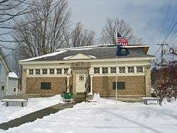 Hyde Park library | |
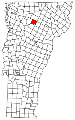 Location of the town of Hyde Park in Vermont | |
| Country | United States |
| State | Vermont |
| County | Lamoille |
| Communities | Hyde Park North Hyde Park Centerville |
| Area | |
| • Total | 39.0 sq mi (101.0 km2) |
| • Land | 37.9 sq mi (98.1 km2) |
| • Water | 1.1 sq mi (2.9 km2) 2.87% |
| Population (2010) | |
| • Total | 2,954 |
| • Density | 76/sq mi (29/km2) |
| Time zone | UTC-5 (EST) |
| • Summer (DST) | UTC-4 (EDT) |
| ZIP code | 05655 |
| Area code(s) | 802 |
| FIPS code | 50-35050[1] |
| GNIS feature ID | 1462122[2] |
Geography
According to the United States Census Bureau, the town has a total area of 39.0 square miles (101.0 km2), of which 37.9 square miles (98.1 km2) is land and 1.1 square miles (2.9 km2) (2.87%) is water.
Demographics

| Historical population | |||
|---|---|---|---|
| Census | Pop. | %± | |
| 1790 | 43 | — | |
| 1800 | 110 | 155.8% | |
| 1810 | 261 | 137.3% | |
| 1820 | 373 | 42.9% | |
| 1830 | 823 | 120.6% | |
| 1840 | 1,080 | 31.2% | |
| 1850 | 1,107 | 2.5% | |
| 1860 | 1,409 | 27.3% | |
| 1870 | 1,624 | 15.3% | |
| 1880 | 1,715 | 5.6% | |
| 1890 | 1,633 | −4.8% | |
| 1900 | 1,472 | −9.9% | |
| 1910 | 1,453 | −1.3% | |
| 1920 | 1,323 | −8.9% | |
| 1930 | 1,165 | −11.9% | |
| 1940 | 1,178 | 1.1% | |
| 1950 | 1,291 | 9.6% | |
| 1960 | 1,219 | −5.6% | |
| 1970 | 1,347 | 10.5% | |
| 1980 | 2,021 | 50.0% | |
| 1990 | 2,344 | 16.0% | |
| 2000 | 2,847 | 21.5% | |
| 2010 | 2,954 | 3.8% | |
| Est. 2014 | 3,040 | [7] | 2.9% |
| U.S. Decennial Census[8] | |||
As of the census[1] of 2000, there were 2,847 people, 1,138 households, and 780 families residing in the town. The population density was 75.2 people per square mile (29.0/km2). There were 1,220 housing units at an average density of 32.2/sq mi (12.4/km2). The racial makeup of the town was 97.75% White, 0.53% Black or African American, 0.53% Native American, 0.39% Asian, and 0.81% from two or more races. Hispanic or Latino of any race were 0.77% of the population.
There were 1,138 households out of which 31.7% had children under the age of 18 living with them, 53.7% were couples living together and joined in either marriage or civil union, 9.3% had a female householder with no husband present, and 31.4% were non-families. 24.4% of all households were made up of individuals and 9.5% had someone living alone who was 65 years of age or older. The average household size was 2.49 and the average family size was 2.92.
In the town, the population was spread out with 24.7% under the age of 18, 7.3% from 18 to 24, 28.7% from 25 to 44, 26.7% from 45 to 64, and 12.5% who were 65 years of age or older. The median age was 38 years. For every 100 females, there were 98.4 males. For every 100 females age 18 and over, there were 96.2 males.
The median income for a household in the town was $38,650, and the median income for a family was $44,185. Males had a median income of $30,000 versus $25,304 for females. The per capita income for the town was $20,293. About 3.2% of families and 5.8% of the population were below the poverty line, including 4.4% of those under age 18 and 7.1% of those age 65 or over.
Villages and bygone villages
- Garfield is located in the northeast corner of Hyde Park. In the late 1800s, Garfield was a village with a store, a post office (added in 1890), a school, and two sawmills. In 1922 the sawmill owned by Charles William Manning (1864–1946) burned down and he decided not to replace it, causing the loss of many jobs. Residents began to leave Garfield. Eventually their abandoned farms reverted to wilderness. The area remains thickly wooded and sparsely developed to this day. It is best known as the Morrisville turnoff point for the Green River Reservoir State Park.
- Hyde Park (village), Vermont
- North Hyde Park, Vermont
- Centerville[9]
Notable people
- Susan Bartlett, member of the Vermont State Senate and assistant to Governor of Vermont Peter Shumlin
- Frank Ellis Boynton, American botanist
- Vernon A. Bullard, United States Attorney for the District of Vermont[10]
- Benjamin N. Hulburd, Chief Justice of the Vermont Supreme Court[11]
- Roger W. Hulburd, Lieutenant Governor of Vermont
- Carroll S. Page, United States Senator
- Wayne H. Page, Adjutant General of the Vermont National Guard
- George M. Powers, Chief Justice of the Vermont Supreme Court[12]
- H. Henry Powers, United States Congressman[13]
- Anson P. K. Safford, Governor of Arizona Territory
- Mary J. Safford, pioneering female physician
See also
- List of villages in Vermont
References
- "U.S. Census website". United States Census Bureau. Retrieved 2008-01-31.
- "US Board on Geographic Names". United States Geological Survey. 2007-10-25. Retrieved 2008-01-31.
- Title 24, Part I, Chapter 1, §9, Vermont Statutes. Accessed 2007-11-01.
- "Find a County". National Association of Counties. Archived from the original on May 31, 2011. Retrieved 2011-06-07.
- Gannett, Henry (1905). The Origin of Certain Place Names in the United States. Govt. Print. Off. pp. 164.
- "Profile for Hyde Park, Vermont". ePodunk. Retrieved 2010-05-10.
- "Annual Estimates of the Resident Population for Incorporated Places: April 1, 2010 to July 1, 2014". Archived from the original on May 23, 2015. Retrieved June 4, 2015.
- "U.S. Decennial Census". United States Census Bureau. Retrieved May 16, 2015.
- "Feature Detail Report for Centerville". United States Geological Survey. Retrieved 14 October 2019.
- Carleton, Hiram (1903). Genealogical and Family History of the State of Vermont. 1. New York, NY: Lewis Publishing Company. pp. 461–462. ISBN 9780806347943.
- "Retired State Chief Justice Hulburd Dies". Burlington Free Press. Burlington, VT. April 10, 1964. p. 1 – via Newspapers.com.
- "Chief Justice Powers Died at Age of 76". Burlington Free Press. Burlington, VT. June 25, 1938. p. 1 – via Newspapers.com.
- "H. Henry Powers Dies". Middlebury Register. Middlebury, VT. December 12, 1913. p. 4 – via Newspapers.com.
External links
| Wikimedia Commons has media related to Hyde Park (town), Vermont. |
- Lamoille Union High School
- Lamoille County Players - performing arts
Municipalities and communities of Lamoille County, Vermont, United States | ||
|---|---|---|
Shire town: Hyde Park | ||
| Towns |  Map of Vermont highlighting Lamoille County | |
| Villages | ||
| CDP |
| |
| Unincorporated communities | ||
| Authority control |
|
|---|