Hoopers Creek, North Carolina
Hoopers Creek is an unincorporated community and census-designated place (CDP) in Henderson County, North Carolina, United States. Its population was 1,056 as of the 2010 census.[2]
Hoopers Creek, North Carolina | |
|---|---|
 Hoopers Creek  Hoopers Creek | |
| Coordinates: 35°26′20″N 82°28′00″W | |
| Country | United States |
| State | North Carolina |
| County | Henderson |
| Area | |
| • Total | 6.979 sq mi (18.08 km2) |
| • Land | 6.967 sq mi (18.04 km2) |
| • Water | 0.012 sq mi (0.03 km2) |
| Elevation | 2,159 ft (658 m) |
| Population | |
| • Total | 1,056 |
| • Density | 150/sq mi (58/km2) |
| Time zone | UTC-5 (Eastern (EST)) |
| • Summer (DST) | UTC-4 (EDT) |
| Area code(s) | 828 |
| GNIS feature ID | 1020823[3] |
| FIPS code | 37-32580 |
Geography
The community is in northern Henderson County, bordered to the west by the town of Fletcher and to the north by Buncombe County. The CDP is in the valley of Hoopers Creek, a west-flowing tributary of Cane Creek and part of the French Broad River watershed. The 2,983-foot (909 m) summit of Burney Mountain is on the northern border of the CDP, and 3,693-foot (1,126 m) Bank Mountain is on the southern border.
Asheville is 14 miles (23 km) north of Hoopers Creek via Mills Gap Road, and Hendersonville is 10 miles (16 km) to the south via Jackson Road and Howard Gap Road.
According to the U.S. Census Bureau, the Hoopers Creek CDP has a total area of 7.0 square miles (18.1 km2), of which 0.01 square miles (0.03 km2), or 0.17%, are water.[4]
Notes
- "US Gazetteer files: 2010, 2000, and 1990". United States Census Bureau. 2011-02-12. Retrieved 2011-04-23.
- "U.S. Census website". United States Census Bureau. Retrieved 2011-05-14.
- "Hoopers Creek". Geographic Names Information System. United States Geological Survey.
- "Geographic Identifiers: 2010 Census Summary File 1 (G001): Hoopers Creek CDP, North Carolina". American Factfinder. U.S. Census Bureau. Archived from the original on February 13, 2020. Retrieved December 20, 2017.
Municipalities and communities of Henderson County, North Carolina, United States | ||
|---|---|---|
| Cities | 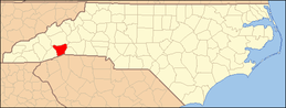 | |
| Towns | ||
| Village | ||
| CDPs | ||
| Unincorporated communities | ||
| Footnotes | ‡This populated place also has portions in an adjacent county or counties | |