Fruitland, Henderson County, North Carolina
Fruitland is an unincorporated community and census-designated place (CDP) in Henderson County, North Carolina, United States. Its population was 2,031 as of the 2010 census.[2]
Fruitland, Henderson County, North Carolina | |
|---|---|
 Fruitland  Fruitland | |
| Coordinates: 35°23′47″N 82°23′35″W | |
| Country | United States |
| State | North Carolina |
| County | Henderson |
| Area | |
| • Total | 8.055 sq mi (20.86 km2) |
| • Land | 8.026 sq mi (20.79 km2) |
| • Water | 0.029 sq mi (0.08 km2) |
| Elevation | 2,215 ft (675 m) |
| Population | |
| • Total | 2,031 |
| • Density | 250/sq mi (97/km2) |
| Time zone | UTC-5 (Eastern (EST)) |
| • Summer (DST) | UTC-4 (EDT) |
| Area code(s) | 828 |
| GNIS feature ID | 985471[3] |
| FIPS code | 37-25160 |
History
A post office called Fruitland was established in 1883, and remained in operation until 1906.[4] The community was named for apple orchards near the original town site.[5]
Geography
Fruitland is in northeastern Henderson County, 7 miles (11 km) northeast of Hendersonville, the county seat. U.S. Route 64 runs along the southern edge of the CDP, leading west to Hendersonville and northeast 8 miles (13 km) to Bat Cave. Asheville is 19 miles (31 km) to the northwest via Terrys Gap Road.
According to the U.S. Census Bureau, the Fruitland CDP has a total area of 8.1 square miles (20.9 km2), of which 0.03 square miles (0.07 km2), or 0.35%, are water.[6]
References
- "US Gazetteer files: 2010, 2000, and 1990". United States Census Bureau. 2011-02-12. Retrieved 2011-04-23.
- "U.S. Census website". United States Census Bureau. Retrieved 2011-05-14.
- "Fruitland". Geographic Names Information System. United States Geological Survey.
- "Henderson County". Jim Forte Postal History. Archived from the original on 24 May 2015. Retrieved 23 May 2015.
- Kramp, Penn (Feb 22, 1987). "Tuxedo: It's not formal wear". The Times-News. p. 27. Retrieved 23 May 2015.
- "Geographic Identifiers: 2010 Census Summary File 1 (G001): Fruitland CDP, North Carolina". American Factfinder. U.S. Census Bureau. Archived from the original on February 13, 2020. Retrieved December 19, 2017.
Municipalities and communities of Henderson County, North Carolina, United States | ||
|---|---|---|
| Cities | 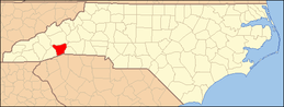 | |
| Towns | ||
| Village | ||
| CDPs | ||
| Unincorporated communities | ||
| Footnotes | ‡This populated place also has portions in an adjacent county or counties | |