Gregg County, Texas
Gregg County is a county located in the eastern part of the U.S. state of Texas. As of the 2010 census, its population was 121,730.[2] Its county seat is Longview.[3] The county is named after John Gregg, a Confederate general killed in action during the American Civil War.[4]
Gregg County | |
|---|---|
 | |
 Seal | |
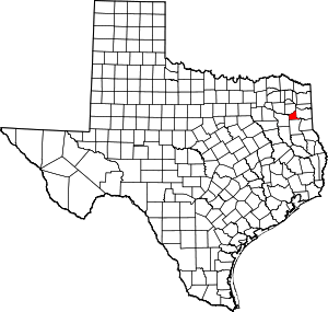 Location within the U.S. state of Texas | |
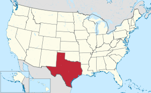 Texas's location within the U.S. | |
| Coordinates: 32°29′N 94°49′W | |
| Country | |
| State | |
| Founded | 1873 |
| Named for | Gen. John Gregg |
| Seat | Longview |
| Largest city | Longview |
| Area | |
| • Total | 276 sq mi (710 km2) |
| • Land | 273 sq mi (710 km2) |
| • Water | 2.5 sq mi (6 km2) 0.9%% |
| Population (2010) | |
| • Total | 121,730 |
| • Estimate (2019) | 123,945 |
| • Density | 445/sq mi (172/km2) |
| Time zone | UTC−6 (Central) |
| • Summer (DST) | UTC−5 (CDT) |
| Congressional district | 1st |
| Website | http://www.co.gregg.tx.us |
Gregg County is part of the Longview, Texas Metropolitan Statistical Area and the Longview–Marshall, Texas combined statistical area. Discovery of oil near Kilgore, Texas, in October 1930 was the beginning of an oil boom that attracted workers to the county and expanded the population by more than 500% by 1940, according to the census. By that time, the economy had stabilized but the East Texas Oil Field, extending in five counties, has continued to be important to the county and region's economy.
History
This area was among early sections settled by United States immigrants before Texas became an independent republic, and after 1845, a state of the United States. It was an area developed as cotton plantations dependent on slave labor of African Americans. Lumbering of the pine forests was also pursued, especially in the early years of clearing the land for cultivation.
Gregg County was organized in 1873 after the American Civil War from portions of existing counties. When the Texas State Legislature convened in January 1873, Democratic representative B. W. Brown of Upshur County introduced a bill to create a new county from parts of Harrison, Rusk, and Upshur Counties. He was likely trying to break up the black majority that dominated county politics in Harrison County. Under Brown's proposal, the county was to be named Roanoke, and Longview was to be the county seat. The proposed name was later changed to honor Texas leader and Confederate General John Gregg, and the county seat was determined by popular election.
Harrison and Rusk Counties resisted efforts to have portions of their territory assigned to Gregg County. When Gregg County was created, it first consisted of about 143 square miles (370 km2) taken from Upshur County, and the Sabine River was its southern boundary. In April 1874, about 141 square miles (370 km2) south of the Sabine River in Rusk County was added to Gregg County. The third portion, of about 145 square miles (380 km2) to be taken from Harrison County, was never realized. Many of its voters continued to elect Republicans to county offices.
By 1919, the county population was 16,700, of which 8,160, or 48%, were black. Most were sharecroppers or tenant farmers raising cotton as a commodity crop. Members of the Negro Business League set up a cooperative store in Longview to compete with white merchants and offer African-American residents more choices for purchases. Beginning July 10, the town had a short-lived Longview Race Riot in which one black man was killed, and several black homes and properties were burned. It was quelled when the sheriff asked for Texas National Guard and other law enforcement. They established a curfew and military occupation.[5][6]
Agricultural work declined during the Great Depression of the 1930s, and many African Americans continued to leave in the Great Migration north to find other work. In October 1930, oil was discovered in Henderson, Texas, near Kilgore. Suddenly, the county economy was booming, and the East Texas Oil Field attracted so many workers that county population increased by more than 500% by 1940. Growth stabilized, but oil has continued to be important. County demographics changed as other workers were attracted to the area. In the early 21st century, slightly less than 20% of the population is African American.
Texas Attorney General John Ben Shepperd, who served from 1953-1957, maintained a ranch in Gregg County near his native Gladewater. He also served on the Gregg County Commissioners Court for a brief period in 1949.[7]
Geography
According to the U.S. Census Bureau, the county has a total area of 276 square miles (710 km2), of which 273 square miles (710 km2) are land and 2.5 square miles (6.5 km2) (0.9%) are covered by water.[8]
Major highways
.svg.png)


Adjacent counties
- Upshur County (north)
- Harrison County (east)
- Rusk County (south)
- Smith County (west)
Demographics
| Historical population | |||
|---|---|---|---|
| Census | Pop. | %± | |
| 1880 | 8,530 | — | |
| 1890 | 9,402 | 10.2% | |
| 1900 | 12,343 | 31.3% | |
| 1910 | 14,140 | 14.6% | |
| 1920 | 16,767 | 18.6% | |
| 1930 | 15,778 | −5.9% | |
| 1940 | 58,027 | 267.8% | |
| 1950 | 61,258 | 5.6% | |
| 1960 | 69,436 | 13.4% | |
| 1970 | 75,929 | 9.4% | |
| 1980 | 99,487 | 31.0% | |
| 1990 | 104,948 | 5.5% | |
| 2000 | 111,379 | 6.1% | |
| 2010 | 121,730 | 9.3% | |
| Est. 2019 | 123,945 | [9] | 1.8% |
| U.S. Decennial Census[10] 1850–2010[11] 2010–2019[2] | |||
As of the census[12] of 2000, 111,379 people, 42,687 households, and 29,667 families resided in the county. The population density was 406 people per square mile (157/km²). The 46,349 housing units averaged 169 per square mile (65/km²). The racial makeup of the county was 72.89% White, 19.86% African American, 0.52% Native American, 0.68% Asian, 4.57% from other races, and 1.49% from two or more races. About 9.14% of the population was Hispanic or Latino of any race.
Of the 42,687 households, 33.50% had children under the age of 18 living with them, 52.00% were married couples living together, 13.50% had a female householder with no husband present, and 30.50% were not families. About 26.10% of all households were made up of individuals, and 10.50% had someone living alone who was 65 years of age or older. The average household size was 2.54 and the average family size was 3.06.
In the county, the population was distributed as 26.70% under the age of 18, 10.30% from 18 to 24, 28.20% from 25 to 44, 21.50% from 45 to 64, and 13.20% who were 65 years of age or older. The median age was 35 years. For every 100 females, there were 93.80 males. For every 100 females age 18 and over, there were 90.40 males.
The median income for a household in the county was $35,006, and for a family was $42,617. Males had a median income of $33,186 versus $21,432 for females. The per capita income for the county was $18,449. About 12.00% of families and 15.10% of the population were below the poverty line, including 20.50% of those under age 18 and 11.40% of those age 65 or over.
Education
These school districts serve Gregg County:
- Gladewater ISD (partly in Smith, Upshur Counties)
- Kilgore ISD (partly in Rusk County)
- Longview ISD
- Pine Tree ISD
- Sabine ISD
- Spring Hill ISD
- White Oak ISD
Media
Gregg County is part of the Tyler/Longview/Jacksonville DMA. Local media outlets are: KLTV, KTRE-TV, KYTX-TV, KFXK-TV, KCEB-TV, and KETK-TV.
The daily Longview News-Journal is the primary newspaper in the county, published in Longview. Coverage of the area can also be found in the Tyler Morning Telegraph, based in Tyler, in Smith County. The Gladewater Mirror has been published since 1949, first as a daily newspaper[13] and then as a weekly newspaper.[14]
Communities
Cities
- Clarksville City (small part in Upshur County)
- East Mountain (mostly in Upshur County)
- Easton (partly in Rusk County)
- Gladewater (partly in Upshur County)
- Kilgore (small part in Rusk County)
- Lakeport
- Longview (small part in Harrison County)
- Warren City (small part in Upshur County)
- White Oak
Census-designated places
Other unincorporated communities
Former communities
- Greggton - annexed to Longview in the 1950s [15]
- Spring Hill - annexed to Longview on October 7, 1983[16]
Gallery
 The annex building is attached to the Gregg County Courthouse.
 The Gregg County Historical Museum is located in the historic district of Longview.
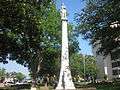 Monument to the Confederate soldier at the Gregg County Courthouse in Longview, completed by Frank Teich, 1911
 Veteran's monument at Gregg County Courthouse
Politics
Before the complete disfranchisement of rural freedmen, Gregg County’s black freedmen allowed it to vote for William McKinley twice, and for several other Republicans during the Third Party System.
Gregg subsequently became a classic “Solid South” Democratic county between 1904 and 1948, but has since become solidly Republican at a Presidential level, although the presence of a sizeable black population has permitted the Democrats to gain a quarter of the countywide total at virtually every election. Nonetheless, Gregg was one of only 16 Texas counties to vote for Barry Goldwater in his 1964 definitive loss, and the last Democrat to carry the county was Harry S. Truman in 1948.
| Year | Republican | Democratic | Third parties |
|---|---|---|---|
| 2016 | 68.9% 28,764 | 28.0% 11,677 | 3.1% 1,308 |
| 2012 | 69.3% 28,742 | 29.9% 12,398 | 0.9% 367 |
| 2008 | 68.5% 29,203 | 30.9% 13,166 | 0.6% 241 |
| 2004 | 70.6% 29,939 | 29.0% 12,306 | 0.4% 153 |
| 2000 | 69.6% 26,739 | 29.3% 11,244 | 1.2% 450 |
| 1996 | 57.7% 21,611 | 36.5% 13,659 | 5.9% 2,208 |
| 1992 | 49.1% 20,542 | 30.6% 12,797 | 20.3% 8,490 |
| 1988 | 67.2% 26,465 | 31.7% 12,486 | 1.1% 436 |
| 1984 | 73.1% 29,697 | 26.3% 10,700 | 0.6% 246 |
| 1980 | 68.4% 23,399 | 29.9% 10,219 | 1.7% 572 |
| 1976 | 63.7% 17,582 | 35.6% 9,827 | 0.7% 203 |
| 1972 | 77.5% 19,927 | 20.7% 5,325 | 1.8% 464 |
| 1968 | 40.1% 9,278 | 24.8% 5,733 | 35.1% 8,109 |
| 1964 | 57.1% 11,761 | 42.5% 8,741 | 0.4% 82 |
| 1960 | 57.0% 10,679 | 41.4% 7,765 | 1.6% 293 |
| 1956 | 65.0% 9,440 | 33.6% 4,881 | 1.4% 198 |
| 1952 | 56.3% 10,583 | 42.4% 7,969 | 1.3% 242 |
| 1948 | 23.5% 2,477 | 48.3% 5,104 | 28.2% 2,984 |
| 1944 | 15.6% 1,412 | 70.5% 6,401 | 13.9% 1,264 |
| 1940 | 14.4% 1,584 | 85.5% 9,391 | 0.1% 15 |
| 1936 | 8.7% 621 | 91.1% 6,489 | 0.2% 11 |
| 1932 | 6.1% 341 | 93.5% 5,204 | 0.4% 20 |
| 1928 | 39.3% 646 | 60.6% 996 | 0.1% 2 |
| 1924 | 10.6% 177 | 77.0% 1,286 | 12.5% 208 |
| 1920 | 16.9% 257 | 69.0% 1,050 | 14.1% 215 |
| 1916 | 15.8% 159 | 81.5% 820 | 2.7% 27 |
| 1912 | 16.5% 129 | 75.5% 590 | 7.9% 62 |
See also
References
- "Gregg County Courthouse, Longview, Texas". www.texasescapes.com. Retrieved 16 March 2018.
- "State & County QuickFacts". United States Census Bureau. Archived from the original on October 18, 2011. Retrieved December 16, 2013.
- "Find a County". National Association of Counties. Archived from the original on 2011-05-31. Retrieved 2011-06-07.
- Gannett, Henry (1905). The Origin of Certain Place Names in the United States. Govt. Print. Off. pp. 144.
- Tuttle, William M., Jr. (1972). "Violence in a "Heathen" Land: The Longview Race Riot of 1919". Phylon. Clark Atlanta University. 33 (4): 324–333. doi:10.2307/273678. ISSN 0031-8906. JSTOR 273678.CS1 maint: ref=harv (link)(subscription required)
- Kenneth R. Durham, Jr. (1980). "THE LONGVIEW RACE RIOT OF 1919" (PDF). East Texas Historical Journal. Archived from the original (PDF) on 2013-05-17. Retrieved 2013-02-23.
- George E. Christian. "John Ben Shepperd". The Handbook of Texas. tshaonline.org. Retrieved July 21, 2009.
- "2010 Census Gazetteer Files". United States Census Bureau. August 22, 2012. Retrieved April 27, 2015.
- "Population and Housing Unit Estimates". United States Census Bureau. May 24, 2020. Retrieved May 27, 2020.
- "U.S. Decennial Census". United States Census Bureau. Retrieved April 27, 2015.
- "Texas Almanac: Population History of Counties from 1850–2010" (PDF). Texas Almanac. Retrieved April 27, 2015.
- "U.S. Census website". United States Census Bureau. Retrieved 2011-05-14.
- "Gladewater Mirror @ Gladewater". Texas Press Association. Retrieved December 19, 2019.
- "About The Gladewater mirror. (Gladewater, Tex.) 1968-current". United States Library of Congress. Retrieved December 20, 2019.
- Long, Chistopher (15 June 2010). "GREGGTON, TX". tshaonline.org. Retrieved 18 March 2018.
- LONG, CHROSTOPHER (15 June 2010). "SPRING HILL, TX [GREGG COUNTY]". tshaonline.org. Retrieved 18 March 2018.
- Leip, David. "Dave Leip's Atlas of U.S. Presidential Elections". uselectionatlas.org. Retrieved 8 April 2018.
External links
- Gregg County government's website
- Gregg County in Handbook of Texas Online at the University of Texas
Places adjacent to Gregg County, Texas | ||||||||||
|---|---|---|---|---|---|---|---|---|---|---|
| ||||||||||
Municipalities and communities of Gregg County, Texas, United States | ||
|---|---|---|
| Cities | Gregg County map | |
| CDPs | ||
| Other unincorporated communities | ||
| Former communities | ||
| Footnotes | ‡This populated place also has portions in an adjacent county or counties | |

| Authority control |
|
|---|