Graciosa, Canary Islands
Graciosa Island or commonly La Graciosa (pronounced [la ɣɾaˈθjosa]; Spanish for "graceful") is a volcanic island in the Canary Islands of Spain, located 2 km (1.2 mi) north of the island of Lanzarote across the Strait of El Río. It was formed by the Canary hotspot. The island is part of the Chinijo Archipelago and the Chinijo Archipelago Natural Park (Parque Natural del Archipiélago Chinijo).[4][5] It is administrated by the municipality of Teguise. In 2018 La Graciosa officially became the eighth Canary Island.[6] Before then, the island had the status of an islet, administratively dependent on the island of Lanzarote. The only two settlements on the island are Caleta de Sebo in the southeastern part of the island and summer-residence Casas de Pedro Barba.
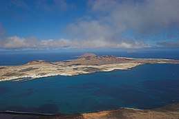 La Graciosa from Mirador Del Rio | |
_-_OSM_Mapnik.svg.png) La Graciosa Location with respect to Lanzarote 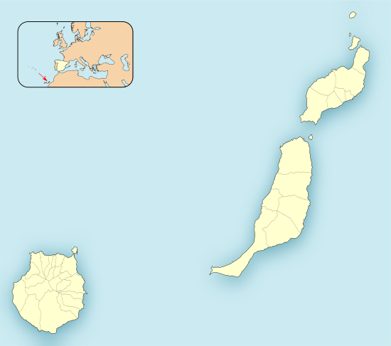 La Graciosa La Graciosa (Province of Las Palmas) 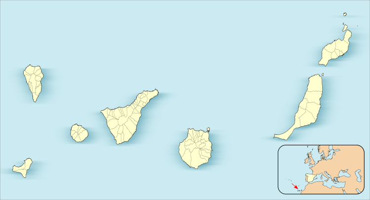 La Graciosa La Graciosa (Canary Islands)  La Graciosa La Graciosa (Spain, Canary Islands) | |
| Geography | |
|---|---|
| Location | Atlantic Ocean |
| Coordinates | 29.250°N 13.508°W |
| Archipelago | Chinijo Archipelago, Canary Islands |
| Area | 29.05 km2 (11.22 sq mi)[1] |
| Coastline | 30.395 km (18.8866 mi)[2] |
| Highest elevation | 266 m (873 ft) |
| Highest point | Agujas Grandes |
| Administration | |
| Autonomous Community | |
| Province | Las Palmas |
| Municipality | Teguise |
| Largest settlement | Caleta de Sebo (pop. 730) |
| Demographics | |
| Population | 734 (2018)[3] |
| Pop. density | 25.27/km2 (65.45/sq mi) |
| Languages | Spanish, specifically Canarian Spanish |
| Additional information | |
| Time zone | |
| • Summer (DST) | |
The population is about 700. Tourism is the main industry along with fishing. Every year, tourists flock to the island for its tempered climate and its sandy volcanic coasts. The island has a school, lyceum, post office, supermarkets, medical center, pharmacy, a Bankia bank branch (in danger of closure as of September 2013[7] but still there in July 2019[8]), port, beaches, bar-restaurants and a square.
Streets and roads on La Graciosa are unpaved sand. Motor vehicles are strictly limited to a handful of licensed vehicles for special purposes. Access to the island is by a 25-minute ferry crossing from Órzola on Lanzarote to the harbour in the village. There is a campsite on the island situated on Playa del Salado at the western edge of Caleta del Sebo.
Geographical features
The island is extremely arid and entirely made up of bushes and dry soil. Its length is 8 km (5.0 mi) and the width is 4 km (2.5 mi), making an area of 29 km2 (11 sq mi). There are no natural water sources on the island; desalinated water has been piped directly from neighbouring Lanzarote since 2001.
There are several isolated mountains on the island, the tallest of which is Agujas Grandes rising to 266 m (873 ft). The second tallest is Agujas Chicas at 228 m (748 ft). Playa de la Cocina is a well known beach in the southwestern part of the island.
.jpg)
References
| Wikimedia Commons has media related to La Graciosa. |
- "Estadística del Territorio" [Territory Statistics] (in Spanish). Instituto Canario de Estadística (ISTAC). Retrieved 2019-07-18.
- "Longitud de costa de los islotes de Lanzarote" [Coastline length of the islets of Lanzarote] (in Spanish). Centro de Datos, Cabildo de Lanzarote. Retrieved 2019-07-18.
- "Población de derecho de Teguise según unidad poblacional. Evolución (2000-2018)" [Legal population of Teguise by settlement. Evolution (2000-2018)] (in Spanish). Centro de Datos, Cabildo de Lanzarote. Retrieved 2019-07-18.
- Protected Natural Areas Archived 2015-04-17 at the Wayback Machine
- Boletín Oficial de Canarias, pages 9723 and 9865-7
- Hugh Morris, Travel news editor. "Nine fascinating facts about the newest Canary Island". The Telegraph. Retrieved 2019-11-21.
- Inza, Carlos (2013-09-04). "El Cabildo pide reconsiderar el cierre de Bankia en La Graciosa" [The Cabildo asks to reconsider the closure of Bankia on La Graciosa] (in Spanish). Canarias7. Retrieved 2019-07-20.
- "Bankia branch in CL THE TEGALA, 3 (Teguise)". bankia.es. Retrieved 2019-07-20.
- R. Pott, J. Hüppe, W. Wildpret de la Torre, Die Kanarischen Inseln. Natur- und Kulturlandschaften, Ulmer Eugen Verlag, 2003, ISBN 9783800132843
Islands and provinces of the Canary Islands | ||
|---|---|---|
| Main islands |  | |
| Other islands | ||
| Provinces | ||