Geography of the Bahamas
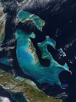
The Bahamas are a group of about 700 islands and cays in the western Atlantic Ocean, of which only between 30 and 40 are inhabited. The largest of the islands is Andros Island, located north of Cuba and 200 kilometres (120 miles) southeast of Florida. The Bimini islands are to its northwest. To the North is the island of Grand Bahama, home to the second-largest city in the country, Freeport. The island of Great Abaco is to its east. In the far south is the island of Great Inagua, the second-largest island in the country. Other notable islands include Eleuthera, Cat Island, San Salvador Island, Acklins, Crooked Island, and Mayaguana. Nassau is the capital and largest city, located on New Providence. The islands have a tropical savannah climate, moderated by the Gulf Stream. The total size is 13,878 km2 (5,358 sq mi). Due to the many widespread islands it has the 41st largest Exclusive Economic Zone of 654,715 km2 (252,787 sq mi).
 | |
| Continent | North America |
|---|---|
| Region | Atlantic Ocean |
| Coordinates | |
| Area | Ranked 155th |
| • Total | 13,878 km2 (5,358 sq mi) |
| • Land | 72.12% |
| • Water | 27.88% |
| Coastline | 3,542 km (2,201 mi) |
| Borders | None |
| Highest point | Cat Island 63 metres (207 ft) |
| Lowest point | Atlantic Ocean 0 m |
| Exclusive economic zone | 654,715 km2 (252,787 sq mi) |
The islands are surface projections of the three oceanic Bahama Banks - the Little Bahama Bank, the Great Bahama Bank, and the westernmost Cay Sal Bank. The highest point is only 63 metres (207 feet) above sea level on Cat Island; the island of New Providence, where the capital city of Nassau is located, reaches a maximum elevation of only thirty-seven meters. The land on the Bahamas has a foundation of fossil coral, but much of the rock is oolitic limestone; the stone is derived from the disintegration of coral reefs and seashells. The land is primarily either rocky or mangrove swamp. Low scrub covers much of the surface area. Pineyards are found on four of the northern islands: Grand Bahama, Great Abaco, New Providence, and Andros. On some of the southern islands, low-growing tropical hardwood flourishes. Although some soil is very fertile, it is also very thin. Only a few freshwater lakes and just one river, located on Andros Island, are found in the Bahamas.
Climate
| Precipitation | Storm | Location | Ref. | ||
|---|---|---|---|---|---|
| Rank | mm | in | |||
| 1 | 747.5 | 29.43 | Noel 2007 | Long Island | [1] |
| 2 | 580.1 | 22.84 | Dorian 2019 | Hope Town | [2] |
| 3 | 500.3 | 19.70 | Matthew 2016 | Matthew Town, Inagua | [3] |
| 4 | 436.6 | 17.19 | Flora 1963 | Duncan Town | [4] |
| 5 | 390.1 | 15.36 | Inez 1966 | Nassau Airport | [4] |
| 6 | 337.1 | 13.27 | Fox 1952 | New Providence | [4] |
| 7 | 321.1 | 12.64 | Michelle 2001 | Nassau | [5] |
| 8 | 309.4 | 12.18 | Erin 1995 | Church Grove | [6] |
| 9 | 260.0 | 9.88 | Fay 2008 | Freeport | [7] |
| 10 | 236.7 | 9.32 | Floyd 1999 | Little Harbor Abacos | [8] |
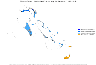
The climate of the Bahama islands is mostly tropical savannah, with two seasons, a hot and wet summer (wet season) and dry winter (dry season).
During the wet season, which extends from May through October, the climate is dominated by warm, moist tropical air masses as the Bermuda High brings a southeasterly flow from the deep tropics. Daily high temperatures are in the 31 °C (87.8 °F)range, with a dew point temperatures in the 75 - 77 F range, creating the typical hot and sultry island weather. Brief, but intense thundershowers are common with thunder and lightning. In the wet season, tropical storms and weak tropical lows may also contribute to the seasonal rainfall.
In dry season, extending from November through April, the subtropical high retreats, and a mix of drier northeast trade winds and occasional westerlies coming down from the North American mainland impact the Bahamas. Sunny, arid conditions prevail in the Bahamas in the dry season, and at times drought conditions can impact farming and agriculture. High temperatures during the dry season are in the 25 °C (77.0 °F) range.
Annual rainfall averages 1,400 millimetres (55 in) and is usually concentrated in the August–October periods. Rainfall often occurs in short-lived, fairly intense, but brief thundershowers accompanied by strong gusty winds, followed by a return the intense sunshine and breezy conditions.
Winds are predominantly easterly throughout the year but tend to become northeasterly from October to April and southeasterly from May to September. These winds seldom exceed twenty-four kilometres per hour except during hurricane season. Although the hurricane season officially lasts from June to November, most hurricanes in the Bahamas occur between July and October. The strongest storm to strike the country was Hurricane Andrew in 1992, until Hurricane Dorian struck in 2019. Damage was estimated at US$250 million and mainly affected agricultural products.
The most intense hurricane to strike the Bahamas was Hurricane Dorian in 2019; winds of up to 355 kilometres per hour (221 mph) were recorded. Many lives were lost, and there was catastrophic damage to buildings, homes, and boats, and sometimes complete destruction. Preliminary damage estimates are in the US$7 billion range. [9]
| Climate data for Nassau Airport, Bahamas | |||||||||||||
|---|---|---|---|---|---|---|---|---|---|---|---|---|---|
| Month | Jan | Feb | Mar | Apr | May | Jun | Jul | Aug | Sep | Oct | Nov | Dec | Year |
| Average high °C | 25.2 | 25.3 | 26.5 | 27.7 | 29.2 | 30.7 | 31.7 | 31.8 | 31.3 | 29.7 | 27.7 | 25.9 | 28.56 |
| Average low °C | 16.7 | 16.9 | 17.7 | 19.0 | 21.0 | 22.9 | 23.7 | 23.8 | 23.6 | 22.2 | 20.0 | 17.7 | 20.43 |
| Average precipitation mm | 47.2 | 40.3 | 39.8 | 53.8 | 116.3 | 232.9 | 157.7 | 215.9 | 171.4 | 175.5 | 56.6 | 51.8 | 1,410 |
| Average high °F | 77.4 | 77.5 | 79.7 | 81.9 | 84.6 | 87.3 | 89.1 | 89.2 | 88.3 | 85.5 | 81.9 | 78.6 | 83.4 |
| Average low °F | 62.1 | 62.4 | 63.9 | 66.2 | 69.8 | 73.2 | 74.7 | 74.8 | 74.5 | 72 | 68 | 63.9 | 68.8 |
| Average precipitation inches | 1.9 | 1.7 | 1.6 | 2.2 | 4.8 | 9.5 | 6.5 | 8.9 | 7 | 7.2 | 2.3 | 2.1 | 55.7 |
| Average relative humidity (%) | 78 | 78 | 76 | 74 | 77 | 79 | 77 | 79 | 81 | 80 | 78 | 78 | 77.92 |
| Source: World Climate [10] | |||||||||||||
Geography
Location
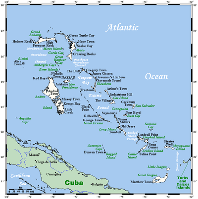
Atlantic Ocean, chain islands in the North Atlantic Ocean, southeast of Florida, northeast of Cuba and northwest of the Turks and Caicos Islands.
Geographic coordinates (capital city Nassau): 25°4′N 77°20′W
Area
- total: 13,880 km²
- county comparison to the world: 161
- land: 3865 square miles; 10,010 km²
- water: 3,870 km²
Area comparative
- Australia comparative: 6 times larger than the Australian Capital Territory
- Canada comparative: a little over twice the size of Prince Edward Island
- Poland comparative: slightly smaller than Świętokrzyskie Voivodeship
- United Kingdom comparative: slightly smaller than Northern Ireland
- United States comparative: slightly smaller than Connecticut
- France comparative: slightly larger than Île-de-France
- The Philippines comparative: slightly larger than Ilocos Region
- Germany comparative: slightly smaller than Schleswig-Holstein
- Russia comparative: slightly smaller than Karachay-Cherkess Republic
Land
Natural resources
Land use
- arable land: 0.8%
- permanent crops: 0.04%
- other: 98.8% (2012)
Coastline
- 3,542 kilometres (2,201 mi)
Sea territory
- 654,715 km2 (252,787 sq mi)
Terrain
- The terrain consists of long, flat coral formations with some low rounded hills.
Extreme points
- Northernmost point – Walker's Cay, Abaco Islands
- Southernmost point – Matthew Town Great Inagua island
- Westernmost point – Alice Town, Bimini
- Easternmost point – Mayaguana Island
- Lowest point – Atlantic Ocean 0 m
- Highest point – Mount Alvernia: 63 m
Irrigated land
- 10 km2 (2003)
Total renewable water resources
- 0.02 km3 (2011)
Environment
Natural hazards
- Hurricanes and other tropical storms that cause extensive flood and wind damage
Environment - Current issues
- Coral reef decay
- Solid waste disposal
Environment - International agreements
Party to these agreements:
- Biodiversity, Climate Change, Climate Change-Kyoto Protocol, Desertification, Endangered Species, Hazardous Wastes, Law of the Sea, Ozone Layer Protection, Ship Pollution, Wetl
Geography - note
- The Bahamas is strategically located adjacent to the United States and Cuba.
- The Bahamas is an extensive island chain of which 30 islands are inhabited.
See also
| Wikimedia Commons has media related to Geography of the Bahamas. |
- Islands of the Bahamas

References
- Brown, Daniel P (December 17, 2007). Tropical Cyclone Report: Hurricane Noel (PDF) (Report). United States National Hurricane Center. p. 4. Retrieved April 25, 2016.
- Avila, Lixion A; Stewart, Stacy R; Berg, Robbie; Hagen, Andrew B (April 20, 2020). Tropical Cyclone Report: Hurricane Dorian (PDF) (Report). United States National Hurricane Center. Retrieved April 28, 2020.
- Stewart, Stacy R (April 3, 2017). Tropical Cyclone Report: Hurricane Matthew (PDF) (Report). United States National Hurricane Center. Retrieved April 6, 2017.
- Roth, David M. (October 18, 2017). "Tropical Cyclone Point Maxima". Tropical Cyclone Rainfall Data. United States Weather Prediction Center. Retrieved November 26, 2017.
- Beven III, John L (January 23, 2002). Tropical Cyclone Report: Hurricane Michelle (PDF) (Report). United States National Hurricane Center. Retrieved June 10, 2012.
- Rappaport, Edward N (November 26, 1995). Preliminary Report: Hurricane Erin (PDF) (Report). United States National Hurricane Center. Retrieved June 10, 2012.
- Beven III, John L; Stewart, Stacey R (February 8, 2009). Tropical Cyclone Report: Tropical Storm Fay 2008 (PDF) (Report). United States National Hurricane Center. Retrieved June 10, 2012.
- Pasch, Richard J; Kimberlain, Todd B; Stewart, Stacey R (November 18, 1999). Preliminary Report: Hurricane Floyd (PDF) (Report). United States National Hurricane Center. Retrieved June 10, 2012.
- https://www.npr.org/2019/09/05/757858192/in-bahamas-officials-assess-generational-devastation-from-hurricane-dorian
- "World Climate". worldclimate.com. Retrieved November 8, 2010.

Further reading
- Chenoweth, Michael (1998). "The Early 19th Century Climate of the Bahamas and a Comparison with 20th Century Averages". Climatic Change. 40 (3–4): 577–603. doi:10.1023/A:1005371320672.
- Carew, James L.; Mylroie, John E. (1997). Geology of the Bahamas (PDF). Retrieved 9 February 2017.
| Sovereign states | 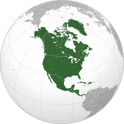 | |
|---|---|---|
Dependencies and other territories |
| |