Geography of Greenland
Greenland is located between the Arctic Ocean and the North Atlantic Ocean, northeast of Canada and northwest of Iceland. The territory comprises the island of Greenland—the largest island in the world—and more than a hundred other smaller islands (see alphabetic list). As an island, Greenland has no land boundaries and 44,087 km of coastline. A sparse population is confined to small settlements along certain sectors of the coast. Greenland possesses the world's second largest ice sheet.
| Native name: Kalaallit Nunaat Grønland Greenland | |
|---|---|
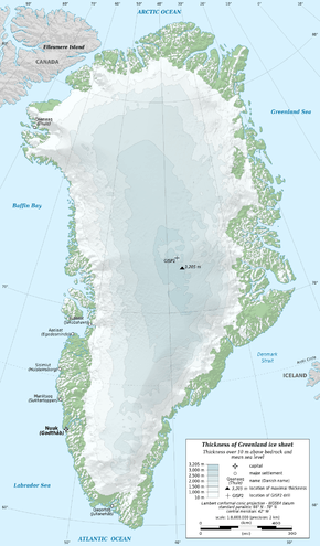 Outline map of Greenland with ice sheet depths. (Note that much of the area in green has permanent snow cover, but less than 10m (33ft) thick.) | |
| Geography | |
| Location | Between the Arctic Ocean and the North Atlantic Ocean |
| Coordinates | 64°10′N 51°43′W |
| Area | 2,166,086 km2 (836,330 sq mi) |
| Area rank | 1st |
| Coastline | 44,087 km (27,394.4 mi) |
| Highest elevation | 3,694 m (12,119 ft) |
| Highest point | Gunnbjørn |
| Administration | |
| Province | |
| Largest settlement | Nuuk (Godthåb) (pop. 17,984) |
| Demographics | |
| Population | 56,732 (February 8, 2020) |
| Pop. density | 0.028/km2 (0.073/sq mi) |
| Ethnic groups | |
Greenland sits atop the Greenland plate, a subplate of the North American plate.[1][2] The Greenland craton is made up of some of the oldest rocks on the face of the earth. The Isua greenstone belt in southwestern Greenland contains the oldest known rocks on Earth, dated at 3.7–3.8 billion years old.[3]
The vegetation is generally sparse, with the only patch of forested land being found in Nanortalik Municipality in the extreme south near Cape Farewell.
The climate is arctic to subarctic, with cool summers and cold winters. The terrain is mostly a flat but gradually sloping icecap that covers all land except for a narrow, mountainous, barren, rocky coast. The lowest elevation is sea level and the highest elevation is the summit of Gunnbjørn Fjeld, the highest point in the Arctic at 3,694 meters (12,119 ft). The northernmost point of the island of Greenland is Cape Morris Jesup, discovered by Admiral Robert Peary in 1900. Natural resources include zinc, lead, iron ore, coal, molybdenum, gold, platinum, uranium, hydropower and fish.
Area
Total area: 2,166,086 km2
Land area: 2,166,086 km2 (410,449 km2 ice-free, 1,755,637 km2 ice-covered)
Maritime claims:
Territorial sea: 3 nautical miles (5.6 km; 3.5 mi)
Exclusive fishing zone: 200 nautical miles (370.4 km; 230.2 mi)
Land use
Arable land:
approximately 6%; some land is used to grow silage.
Permanent crops:
Approximately 0%
Other:
100% (2012 est.)
The total population comprises around 56,000 inhabitants, of whom approximately 18,000 live in the capital, Nuuk.
Natural hazards
Continuous ice sheet covers 84% of the country; the rest is permafrost.
Environment – current issues
Protection of the Arctic environment, climate change, pollution of the food chain, excessive hunting[4] of endangered species (walrus, polar bears, narwhal, beluga whale and several sea birds).
Climate

Greenland's climate is a tundra climate on and near the coasts and an ice cap climate in inland areas. It typically has short, cool summers and long, moderately cold winters.
Due to Gulf Stream influences, Greenland's winter temperatures are very mild for its latitude. In Nuuk, the capital, average winter temperatures are only −9 °C (16 °F).[5] In comparison, the average winter temperatures for Iqaluit, Nunavut, Canada, are around −27 °C (−17 °F).[6] Conversely, summer temperatures are very low, with an average high around 10 °C (50 °F).[5] This is too low to sustain trees, and the land is treeless tundra.
On the Greenland ice sheet, the temperature is far below freezing throughout the year,[7] and record high temperatures have peaked only slightly above freezing. The record high temperature at Summit Camp is 2.2 °C (36.0 °F).[8]
In the far south of Greenland, there is a very small forest in the Qinngua Valley, due to summer temperatures being barely high enough to sustain trees. There are mountains over 1,500 metres (4,900 ft) high surrounding the valley, which protect it from cold, fast winds travelling across the ice sheet.[9] It is the only natural forest in Greenland, but is only 15 kilometres (9.3 mi) long.
| Climate data for Nuuk | |||||||||||||
|---|---|---|---|---|---|---|---|---|---|---|---|---|---|
| Month | Jan | Feb | Mar | Apr | May | Jun | Jul | Aug | Sep | Oct | Nov | Dec | Year |
| Record high °C (°F) | 13.5 (56.3) |
13.0 (55.4) |
13.2 (55.8) |
14.6 (58.3) |
18.3 (64.9) |
23.8 (74.8) |
26.3 (79.3) |
25.1 (77.2) |
23.8 (74.8) |
19.9 (67.8) |
15.8 (60.4) |
13.2 (55.8) |
26.3 (79.3) |
| Average high °C (°F) | −5.6 (21.9) |
−6.3 (20.7) |
−6.8 (19.8) |
−1.4 (29.5) |
3.4 (38.1) |
7.7 (45.9) |
10.2 (50.4) |
10.4 (50.7) |
6.3 (43.3) |
1.8 (35.2) |
−1.1 (30.0) |
−3.4 (25.9) |
1.3 (34.3) |
| Daily mean °C (°F) | −8.2 (17.2) |
−9.1 (15.6) |
−9.2 (15.4) |
−3.6 (25.5) |
0.8 (33.4) |
4.4 (39.9) |
6.8 (44.2) |
7.3 (45.1) |
3.7 (38.7) |
−0.3 (31.5) |
−3.4 (25.9) |
−5.8 (21.6) |
−1.4 (29.5) |
| Average low °C (°F) | −10.4 (13.3) |
−11.5 (11.3) |
−11.4 (11.5) |
−5.7 (21.7) |
−2.5 (27.5) |
1.7 (35.1) |
3.8 (38.8) |
4.0 (39.2) |
2.8 (37.0) |
−2.1 (28.2) |
−5.4 (22.3) |
−8 (18) |
−3.7 (25.3) |
| Record low °C (°F) | −32.5 (−26.5) |
−29.6 (−21.3) |
−27.5 (−17.5) |
−30.0 (−22.0) |
−19.0 (−2.2) |
−10.3 (13.5) |
−6.6 (20.1) |
−4.7 (23.5) |
−8.2 (17.2) |
−16.6 (2.1) |
−24.4 (−11.9) |
−25.2 (−13.4) |
−32.5 (−26.5) |
| Average precipitation mm (inches) | 54.7 (2.15) |
51.1 (2.01) |
49.1 (1.93) |
45.6 (1.80) |
56.5 (2.22) |
60.6 (2.39) |
81.3 (3.20) |
89.1 (3.51) |
90.2 (3.55) |
66.5 (2.62) |
75.2 (2.96) |
62.0 (2.44) |
781.6 (30.77) |
| Average precipitation days (≥ 0.1 mm) | 13.8 | 12.7 | 15.1 | 13.2 | 13.0 | 10.5 | 12.5 | 12.5 | 14.1 | 13.5 | 14.3 | 14.4 | 159.6 |
| Average snowy days | 13.6 | 12.1 | 14.5 | 11.4 | 9.4 | 2.8 | 0.1 | 0.2 | 4.3 | 9.8 | 12.7 | 13.8 | 104.7 |
| Average relative humidity (%) | 78 | 79 | 81 | 81 | 84 | 84 | 87 | 87 | 83 | 78 | 76 | 77 | 81 |
| Mean monthly sunshine hours | 15.5 | 65.0 | 148.8 | 180.0 | 189.1 | 204.0 | 195.3 | 164.3 | 141.0 | 80.6 | 30.0 | 6.2 | 1,419.8 |
| Mean daily sunshine hours | 0.5 | 2.3 | 4.8 | 6.0 | 6.1 | 6.8 | 6.3 | 5.3 | 4.7 | 2.6 | 1.0 | 0.2 | 3.9 |
| Source 1: Danish Meteorological Institute[5][10] | |||||||||||||
| Source 2: Meteo Climat (record highs and lows),[11] Deutscher Wetterdienst (humidity 1961–1990, sun 1980–1990)[12] | |||||||||||||
Climate change
The Greenland ice sheet is 3 kilometers (1.9 mi) thick and broad enough to blanket an area the size of Mexico. The ice is so massive that its weight presses the bedrock of Greenland below sea level and is so all-concealing that not until recently did scientists discover Greenland's Grand Canyon or the possibility that Greenland might actually be three islands.[13]
If the ice melted, the interior bedrock below sea level would be covered by water. It is not clear whether this water would be at sea level or a lake above sea level. If it would be at sea level it could connect to the sea at Ilulissat Icefjord, in Baffin Bay and near Nordostrundingen, creating three large islands.[14] But it is most likely that it would be a lake with one drain.
It is thought that before the Ice Age, Greenland had mountainous edges and a lowland (and probably very dry) center which drained to the sea via one big river flowing out westwards, past where Disko Island is now.
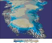
There is concern about sea level rise caused by ice loss (melt and glaciers falling into the sea) on Greenland. Between 1997 and 2003 ice loss was 68–92 km3/a (16–22 cu mi/a), compared to about 60 km3/a (14 cu mi/a) for 1993/4-1998/9. Half of the increase was from higher summer melting, with the rest caused by the movements of some glaciers exceeding the speeds needed to balance upstream snow accumulation.[15] A complete loss of ice on Greenland would cause a sea level rise of as much as 6.40 meters (21.0 ft).
Researchers at NASA's Jet Propulsion Laboratory and the University of Kansas reported in February 2006 that the glaciers are melting twice as fast as they were five years ago. By 2005, Greenland was beginning to lose more ice volume than anyone expected – an annual loss of up to 52 cubic miles or 217 cubic kilometres per year, according to more recent satellite gravity measurements released by JPL. The increased ice loss may be partially offset by increased snow accumulation due to increased precipitation.
Between 1991 and 2006, monitoring of the weather at one location (Swiss Camp) found that the average winter temperature had risen almost 10 °F (5.6 °C).
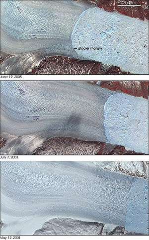
Recently, Greenland's three largest outlet glaciers have started moving faster, satellite data show. These are the Jakobshavn Isbræ at Ilulissat on the western edge of Greenland, and the Kangerdlugssuaq and Helheim glaciers on the eastern edge of Greenland. The two latter accelerated greatly during the years 2004–2005, but returned to pre-2004 velocities in 2006.[16] The accelerating ice flow has been accompanied by a dramatic increase in seismic activity. In March 2006, researchers at Harvard University and the Lamont-Doherty Earth Observatory at Columbia University reported that the glaciers now generate swarms of earthquakes up to magnitude 5.0.[13]
The retreat of Greenland's ice is revealing islands that were thought to be part of the mainland. In September 2005 Dennis Schmitt discovered an island 400 miles (644 km) north of the Arctic Circle in eastern Greenland which he named Uunartoq Qeqertaq, Inuit for "warming island".[17]
Future projections
In the Arctic, temperatures are rising faster than anywhere else in the world. Greenland is losing 200 billion tonnes of ice per year. Research suggests that this could increase the sea levels' rise by 30 centimeters by the end of the century. These projections have the possibility of changing as satellite data only dates back to 40 years ago. This means that researchers must view old photographs of glaciers and compare them to ones taken today to determine the future of Greenland's ice.[18]
Temperature extremes
| Climate data for Greenland | |||||||||||||
|---|---|---|---|---|---|---|---|---|---|---|---|---|---|
| Month | Jan | Feb | Mar | Apr | May | Jun | Jul | Aug | Sep | Oct | Nov | Dec | Year |
| Record high °C (°F) | 15.3 (59.5) |
16.0 (60.8) |
16.0 (60.8) |
19.1 (66.4) |
24.8 (76.6) |
30.1 (86.2) |
26.3 (79.3) |
25.2 (77.4) |
24.9 (76.8) |
19.3 (66.7) |
21.6 (70.9) |
15.9 (60.6) |
30.1 (86.2) |
| Record low °C (°F) | −66.1 (−87.0) |
−63.3 (−81.9) |
−64.8 (−84.6) |
−57.3 (−71.1) |
−49.0 (−56.2) |
−37.5 (−35.5) |
−33.0 (−27.4) |
−39.2 (−38.6) |
−46.0 (−50.8) |
−55.4 (−67.7) |
−60.0 (−76.0) |
−69.4 (−92.9) |
−69.4 (−92.9) |
| Source 1: Weather Extremes Greenland, retrieved 28 July 2020 (all record lows except for Jan, Mar, May, Dec)(Jan and Feb record highs), Meteo Climat (Mar-Dec highs) | |||||||||||||
| Source 2: Eismitte record low, retrieved 28 July 2020 (March record low),
May record low at Summit, retrieved 28 July 2020 (May record low), WUnderground, retrieved 28 July 2020 (record low all time) | |||||||||||||
Highest temperatures
| Month | Temperature | Date | Location |
|---|---|---|---|
| January | 15.3 °C (59.5 °F) | 29 January 2003 | Nuuk, Sermersooq |
| February | 16.0 °C (60.8 °F) | 20 February 2005 | Nanortailak, Kujalleq |
| March | 16.0 °C (60.8 °F) | 31 March 1975 | Narsarsuaq, Kujalleq |
| April | 19.1 °C (66.4 °F) | 26 April 2016 | Narsarsuaq, Kujalleq |
| May | 24.8 °C (76.6 °F) | 29 May 2012 | Narsarsuaq, Kujalleq |
| June | 30.1 °C (86.2 °F) | 23 June 1915 | Ivittuut, Sermersooq |
| July | 26.3 °C (79.3 °F) | 6 July 2008 | Nuuk, Sermersooq |
| August | 25.2 °C (77.4 °F) | 3 August 1899 | Tasillaq, Sermersooq |
| September | 24.9 °C (76.8 °F) | 2 September 2010 | Nuuk, Sermersooq |
| October | 19.3 °C (66.7 °F) | 5 October 2016 | Tasillaq, Sermersooq |
| November | 21.6 °C (70.9 °F) | 21 November 2015 | Tasillaq, Sermersooq |
| December | 15.9 °C (60.6 °F) | 21 December 2001 | Narsarsuaq, Kujalleq |
Lowest temperatures
| Month | Temperature | Date | Location |
|---|---|---|---|
| January | −66.1 °C (−87.0 °F) | 9 January 1954 | North Ice, Northeast Greenland |
| February | −63.3 °C (−81.9 °F) | 21 February 2002 | Summit Camp Station, Northeast Greenland |
| March | −64.8 °C (−84.6 °F) | 20 March 1931 | Eismitte, Northeast Greenland |
| April | −57.3 °C (−71.1 °F) | 21 April 2011 | Summit Camp Station, Northeast Greenland |
| May | −49.0 °C (−56.2 °F) | 9 May 2018 | Summit Camp Station, Northeast Greenland |
| June | −37.5 °C (−35.5 °F) | 1 June 2011 | Summit Camp Station, Northeast Greenland |
| July | −33.0 °C (−27.4 °F) | 4 July 2017 | Summit Camp Station, Northeast Greenland |
| August | −39.2 °C (−38.6 °F) | 29 August 2004 | Summit Camp Station, Northeast Greenland |
| September | −46.0 °C (−50.8 °F) | 24 September 2009 | Summit Camp Station, Northeast Greenland |
| October | −55.4 °C (−67.7 °F) | 26 October 2018 | Summit Camp Station, Northeast Greenland |
| November | −60.0 °C (−76.0 °F) | 26 November 2001 | Summit Camp Station, Northeast Greenland |
| December | −69.4 °C (−92.9 °F) | 22 December 1991 | Klinck Station, Northeast Greenland |
Topography
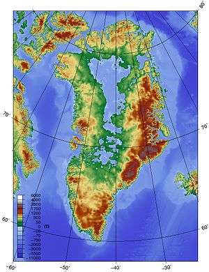
The ice sheet covering Greenland varies significantly in elevation across the landmass, rising dramatically between the coastline at sea level and the East-Central interior, where elevations reach 3,200 meters (10,500 ft).[19] The coastlines are rocky and predominantly barren with fjords.[20] Numerous small islands spread from the Central to Southern coastlines.[20]
Greenland's mountain ranges are partially or completely buried by ice. The highest mountains are in the Watkins Range, which runs along the eastern coast. Greenland's highest mountain is Gunnbjorn Fjeld with a height of 3,700 meters (12,139 ft).[20]
Scientists discovered an asteroid impact crater in the northwestern region of Greenland, buried underneath the ice sheet. At a size larger than Washington, D.C., it is the first impact crater found beneath one of Earth's ice sheets.[21]
Extreme points
This is a list of the extreme points of Greenland, the points that are farther north, south, east or west than any other location.
Territory of Greenland
- Northernmost point — Kaffeklubben Island (83°40'N) – the northernmost permanent land in the world. There are also some shifting gravel bars that lie north of Kaffeklubben, the most famous being Oodaaq.
- Southernmost point — unnamed islet 2.3 km south of Cape Farewell, Egger Island (59°44'N)
- Westernmost point — Nordvestø, Carey Islands (73°10'W)
- Easternmost point — Nordostrundingen, Greenland (11°19'W)
- Highest point — Gunnbjørn Fjeld, 3,694 meters (12,119 ft)
Island of Greenland
- Northernmost point — Cape Morris Jesup (83°39'N)
- Southernmost point — Peninsula near Nanortalik (60°08′31″N)
- Westernmost point — Cape Alexander (73°08'W)
- Easternmost point — Nordostrundingen, Greenland (11°19'W)
- Highest point — Gunnbjørn Fjeld, 3,694 meters (12,119 ft).
Towns
Greenland has 18 towns – settlements with more than 500 inhabitants. Nuuk is the largest town – and the capital – with roughly one third of the country's urban population. Sisimiut with approximately 5,500 inhabitants is the second largest town, while Ilulissat is number three with around 5,000 inhabitants.
History of exploration
Gallery
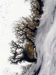
 An enlargeable satellite composite image of Greenland
 Sermeq Kujatdlek Glacier on Greenland's west coast
 Nunataks on Greenland's east coast
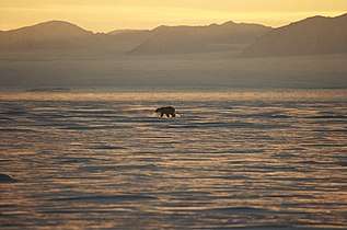 A polar bear on Greenland's eastern coast
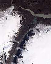 Small glaciers spilling into a mostly dry valley in western Greenland
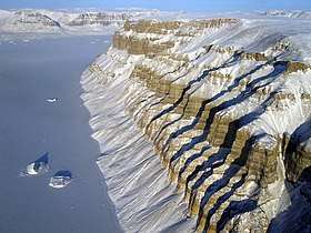 View of deep canyons, or fjords, along the coast of northwestern Greenland
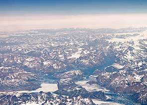 Mountains in southern Greenland, as seen from an altitude of approximately 34,000 feet
See also
References
- Chisholm, Hugh, ed. (1911). . Encyclopædia Britannica (11th ed.). Cambridge University Press.
- "BAFFIN BAY" (PDF). Indian and Northern Affairs Canada. Archived from the original (PDF) on 2011-06-13. Retrieved 2009-10-04. Cite journal requires
|journal=(help) - Appel, Peter W.U., Hugh R. Rollinson, and Jacques L.R. Touret. (2001) "Remnants of an Early Archaean (>3.75 Ga) sea-floor, hydrothermal system in the Isua Greenstone Belt." Precambrian Research, 112.1–2, 15 November, pp. 27–49.
- "Archived copy". Archived from the original on 2020-01-09. Retrieved 2007-02-05.CS1 maint: archived copy as title (link)
- "DMI Report 18–19: Climatological Standard Normals 1981–2010 Denmark, The Faroe Islands and Greenland Based on Data Published in DMI Reports 18–08, 18–04 and 18–05" (PDF). Danish Meteorological Institute. Archived from the original (PDF) on 10 February 2019. Retrieved 10 February 2019.
- "Iqaluit A". Canadian Climate Normals 1981–2010. Environment Canada. 31 October 2011. Climate ID: 2402590. Archived from the original on May 16, 2017. Retrieved February 24, 2014.
- Shuman, Christopher A.; Steffen, Konrad; Box, Jason E.; Stearns, Charles R. (2001). <0741:adyoto>2.0.co;2 "A Dozen Years of Temperature Observations at the Summit: Central Greenland Automatic Weather Stations 1987–99". Journal of Applied Meteorology. American Meteorological Society. 40 (4): 741–752. doi:10.1175/1520-0450(2001)040<0741:adyoto>2.0.co;2. ISSN 0894-8763.
- "Vejrekstremer Grønland". Danish Meteorological Institute (in Danish).
- "Qinngua Valley". Wondermondo. Retrieved 2015-01-20.
- "The Observed Climate of Greenland, 1958–99 with Climatological Standard Normals, 1961–90" (PDF). Danish Meteorological Institute. Retrieved 31 October 2019.
- "Station Nuuk" (in French). Météo Climat. Retrieved 10 February 2019.
- "Klimatafel von Godthaab (Nuuk) / Grönland (zu Dänemark)" (PDF). Baseline climate means (1961–1990) from stations all over the world (in German). Deutscher Wetterdienst. Retrieved 16 December 2019.
- "Greenland's Ice Sheet Is Slip-Sliding Away", Los Angeles Times, June 25, 2006
- "Is the world's fastest-moving glacier set to speed up even more?". Center for Environmental Journalism. October 23, 2010. Archived from the original on December 3, 2011.
- Krabill, W., et al., 2004, Greenland Ice Sheet: increased Coastal Thinning, Geophysical Research Letters, 31 L24402
- Howat, Ian M.; Joughin, Ian R.; Scambos, Ted A. (8 February 2007). "Rapid Changes in Ice Discharge from Greenland Outlet Glaciers". Science. 315 (5818): 1559–61. Bibcode:2007Sci...315.1559H. CiteSeerX 10.1.1.395.1108. doi:10.1126/science.1138478. PMID 17289940.
- "The Warming of Greenland", New York Times, January 16, 2007
- "180,000 forgotten photos reveal the future of Greenland’s ice", Nature, July 27, 2016
- "Topography of Greenland". earthobservatory.nasa.gov. 2004-12-26. Retrieved 2018-11-15.
- "Greenland Landforms and Land Statistics". www.worldatlas.com. Retrieved 2018-11-15.
- "Ice Age Asteroid Crater Discovered Beneath Greenland Glacier". Retrieved 2018-11-15.
External links
| Wikimedia Commons has media related to Geography of Greenland. |
- www.geus.dk Geological map of Greenland from the Geological Survey of Denmark and Greenland (GEUS).
- "Times Atlas reviews Greenland map accuracy after climate change row" – The Guardian, 22 September 2011
| |||||||
| History |
|  | |||||
| Geography |
| ||||||
| Politics |
| ||||||
| Economy |
| ||||||
| Society |
| ||||||
| Sovereign states |  | |
|---|---|---|
Dependencies and other territories |
| |