Fort Deposit, Alabama
Fort Deposit is a town in Lowndes County, Alabama, United States. Since 1890, it has been the largest town in Lowndes County.[3] At the 2010 census the population was 1,344, up from 1,270 in 2000. It is part of the Montgomery Metropolitan Statistical Area.
Fort Deposit, Alabama | |
|---|---|
 Fort Deposit, Alabama | |
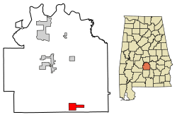 Location of Fort Deposit in Lowndes County, Alabama. | |
| Coordinates: 31°59′16″N 86°34′16″W | |
| Country | United States |
| State | Alabama |
| County | Lowndes |
| Area | |
| • Total | 5.66 sq mi (14.66 km2) |
| • Land | 5.66 sq mi (14.66 km2) |
| • Water | 0.00 sq mi (0.00 km2) |
| Elevation | 466 ft (142 m) |
| Population (2010) | |
| • Total | 1,344 |
| • Estimate (2019)[2] | 1,155 |
| • Density | 204.03/sq mi (78.77/km2) |
| Time zone | UTC-6 (Central (CST)) |
| • Summer (DST) | UTC-5 (CDT) |
| ZIP code | 36032 |
| Area code(s) | 334 |
| FIPS code | 01-27520 |
| GNIS feature ID | 0118518 |
This town is named after a fort that was built under the order of General Andrew Jackson. This was a supply fort that was built to serve the soldiers during the Creek Indian War. There is an annual arts and crafts fair called Calico Fort on the second weekend of April every year.
It was incorporated on February 13, 1891. It reportedly sits on the highest point of land between Montgomery and New Orleans, Louisiana.[4]
Geography
Fort Deposit is located at 31°59′16″N 86°34′16″W (31.987872, -86.571249).[5]
According to the U.S. Census Bureau, the town has a total area of 5.6 square miles (15 km2), all land.
Demographics
| Historical population | |||
|---|---|---|---|
| Census | Pop. | %± | |
| 1880 | 350 | — | |
| 1890 | 518 | 48.0% | |
| 1900 | 1,078 | 108.1% | |
| 1910 | 893 | −17.2% | |
| 1920 | 830 | −7.1% | |
| 1930 | 1,092 | 31.6% | |
| 1940 | 1,351 | 23.7% | |
| 1950 | 1,358 | 0.5% | |
| 1960 | 1,466 | 8.0% | |
| 1970 | 1,438 | −1.9% | |
| 1980 | 1,519 | 5.6% | |
| 1990 | 1,240 | −18.4% | |
| 2000 | 1,270 | 2.4% | |
| 2010 | 1,344 | 5.8% | |
| Est. 2019 | 1,155 | [2] | −14.1% |
| U.S. Decennial Census[6] 2013 Estimate[7] | |||
At the 2000 census there were 1,270 people, 489 households, and 349 families in the town. The population density was 225.1 people per square mile (86.9/km2). There were 569 housing units at an average density of 100.9 per square mile (39.0/km2). The racial makeup of the town was 68.19% Black or African American, 31.50% White and 0.31% from two or more races. 0.47% of the population were Hispanic or Latino of any race.[8] Of the 489 households 35.0% had children under the age of 18 living with them, 39.3% were married couples living together, 27.4% had a female householder with no husband present, and 28.6% were non-families. 25.6% of households were one person and 9.6% were one person aged 65 or older. The average household size was 2.60 and the average family size was 3.12.
The age distribution was 29.8% under the age of 18, 8.6% from 18 to 24, 27.1% from 25 to 44, 21.7% from 45 to 64, and 12.8% 65 or older. The median age was 35 years. For every 100 females, there were 86.2 males. For every 100 women age 18 and over, there were 83.0 men.
The median household income was $20,433 and the median family income was $24,250. Males had a median income of $27,391 versus $20,882 for females. The per capita income for the town was $12,584. About 29.8% of families and 35.3% of the population were below the poverty line, including 42.8% of those under age 18 and 34.2% of those age 65 or over.
2010 census
At the 2010 census there were 1,344 people, 512 households, and 348 families in the town. The population density was 240 people per square mile (92.1/km2). There were 592 housing units at an average density of 105.7 per square mile (40.5/km2). The racial makeup of the town was 75.5% Black or African American, 23.7% White and 0.6% from two or more races. 0.4% of the population were Hispanic or Latino of any race.[9] Of the 512 households 28.9% had children under the age of 18 living with them, 34.8% were married couples living together, 29.3% had a female householder with no husband present, and 32.0% were non-families. 28.9% of households were one person and 11.2% were one person aged 65 or older. The average household size was 2.63 and the average family size was 3.28.
The age distribution was 29.5% under the age of 18, 9.6% from 18 to 24, 22.1% from 25 to 44, 26.6% from 45 to 64, and 12.2% 65 or older. The median age was 34.3 years. For every 100 females, there were 86.9 males. For every 100 women age 18 and over, there were 76.7 men.
The median household income was $30,000 and the median family income was $31,591. Males had a median income of $41,579 versus $25,341 for females. The per capita income for the town was $14,411. About 19.4% of families and 22.2% of the population were below the poverty line, including 43.6% of those under age 18 and 25.4% of those age 65 or over.
Notable people
- Richard Williamson, former NFL head coach (Tampa Bay Buccaneers)
- Glenn Dowling Frazier, a subject of Ken Burns' documentary The War
- Ren Heartsil, known as the Mayor locally, has won the hot dog eating contest at the county fair for a record 41 years in a row.
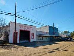
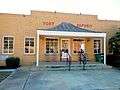
Gallery
 Fort Deposit Town Hall
 Fort Deposit Post Office (ZIP code:36032)
 Fort Deposit Fire Department
 Fort Deposit Public Library
 Fort Deposit United Methodist Church, with separate entrances for men and women
References
- "2019 U.S. Gazetteer Files". United States Census Bureau. Retrieved June 29, 2020.
- "Population and Housing Unit Estimates". United States Census Bureau. May 24, 2020. Retrieved May 27, 2020.
- 1830-2010 U.S. Censuses research on Lowndes County, Alabama communities
- http://www.encyclopediaofalabama.org/article/h-3017
- "US Gazetteer files: 2010, 2000, and 1990". United States Census Bureau. 2011-02-12. Retrieved 2011-04-23.
- "U.S. Decennial Census". Census.gov. Retrieved June 6, 2013.
- "Annual Estimates of the Resident Population: April 1, 2010 to July 1, 2013". Archived from the original on May 22, 2014. Retrieved June 3, 2014.
- "U.S. Census website". United States Census Bureau. Retrieved 2008-01-31.
- "U.S. Census website". United States Census Bureau. Retrieved 2015-08-01.
Map of Fort Dollar of 1812 puts it North of Arab Alabama.
Fort Dollar appears in 1793 in Town Creek, Alabama clear across the Northern part of the state.
External links
Municipalities and communities of Lowndes County, Alabama, United States | ||
|---|---|---|
| Towns | 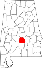 Map of Alabama highlighting Lowndes County | |
| Unincorporated communities | ||
| Authority control |
|
|---|