China–Vietnam border
The border between China and Vietnam consists of a terrestrial border in southern China and northern Vietnam, and a maritime border in Gulf of Tonkin and South China Sea.

While disputes over the terrestrial border have been largely settled with the signing of a land boundary treaty between the two countries, the maritime border is currently been undefined due to disputes over the ownership of islands, territorial waters, including over the Spratly and Paracel Islands, and territorial waters.[1]
Land border


The terrestrial border stretches about 1,444 km[1] from the China-Laos-Vietnam tripoint on the peak of the Shiceng Dashan peak in the west to the mouth of the Beilun/Ka Long River near the Chinese city of Dongxing and the Vietnamese city of Móng Cái in the east. The border passes through isolated mountainous areas inhabited by ethnic minorities of both China and Vietnam.
In several areas, the land border between the two countries runs along rivers. In particular, the border follows the Red River on its section from the mouth of the Longbao River (near Wudaokou village in Hekou County) to the mouth of the Nanxi River (between downtown Hekou and Lào Cai). The lower sections of the Longbao and Nanxi are border rivers as well.
History
An aftermath of the Lý–Song War (1075-1077) that still exists today resulted from an agreement that was negotiated by both sides that fixed the two country's borders the resulting line of demarcation exists largely unmodified to the present day.[2]
Treaty of Tientsin 1885
The Treaty of Tientsin (1885), after the end of the Sino-French War, provided for the demarcation of the border between China and Vietnam (which then part of French Indochina). Article 3 of the treaty provided for the appointment of a Sino-French commission to demarcate the border between Tonkin and China, which largely forms today's China–Vietnam border. China's commissioners were Chou Te-jun (周德潤), Hung Lu-ssu (鴻臚寺) and Ch'ing Teng-ch'eng (卿鄧承). The French commission was led by M. Bourcier Saint-Chaffray, and its members included M. Scherzer, the French consul in Canton, Dr Paul Neis, a noted Indochina explorer, Lieutenant-Colonel Tisseyre, Captain Bouinais, and M. Pallu de la Barrière (though the latter took no part in the commission's work). In preparation for the commission's work General de Courcy despatched French troops to occupy Lạng Sơn, That Khe and other border towns in October 1885.
Demarcation work began in late 1885 and was completed in 1887. The French rejected Chinese claims to the Vietnamese town of Dong Dang, close to the Guangxi border and the site of a French victory during the Sino-French War, but agreed that the Pak-lung peninsula (白龍尾) on the western border of Guangdong province should be awarded to China. A dispute over two areas on the border between Yunnan province and Tonkin was settled by the award of Meng-suo (猛梭) and Meng-lai (猛賴) to Vietnam and the transfer of a large tract of fertile arable land between Ma-pai-kuan (馬白關) and Nan-tan-shan (南丹山) to China. An agreement confirming the new border between Vietnam and China was signed in Peking on 26 June 1887 by French and Chinese representatives.[3]
Boundary Conventions of 1887 and 1895
The 1887 Convention, signed on 26 June, and 1895 Additional Convention between the French Government on behalf of Vietnam and the Qing Dynasty were considered the first international legal documents determining the border between Vietnam and China. The borderline that was jointly defined by the French and the Qing Dynasty largely followed the borderline already formed through history. The conventions also resulted in 341 simple border markers from Mong Cai to the Laos-China border being erected.[1]
The border demarcation between the French and the Qing Dynasty was described as being carried out under "incomplete technical and practical conditions and incomplete and unclear and inaccurate texts and maps of many border sections." The border markers were erected not based on a coordinate grid and many suffered damage, were lost through time or removed. Many of the original maps also no longer existed and migration of populations took place not in accordance with the de jure borderline. All these factors posed difficulties to border management.[1]
20th and 21st Century
During the Chinese Civil War, China used the border near Vietnam as a refueling station while also giving aid to the Vietnamese who were fighting the French in the First Indochina War.
Border crossings and trade points

China and Vietnam signed an agreement on border trade in 1991. In 1992, 21 border trade points (cross border markets and goods import/export but limited through access for people) were opened of which four also served as border crossings.[4]
- List of border crossings and trade points
The major border crossings are highlighted in bold. From west to east:
- Longfu - A Pa Chải (trade point)[5]
- Yakoushuitang - U Ma Tu Khoòng (trade point)[6]
- Jinshuihe - Ma Lù Thàng[7]
- Hekou, Guangxi - Lào Cai City, Lào Cai
- Qiaotou - Mường Khuơng (trade point)
- Tianbao - Thanh Thủy[8]
- Tianpeng - Săm Pun[9]
- Pingmeng - Sóc Giang[10]
- Longbang - Trà Lĩnh, Cao Bằng
- Yuexu - Pò Peo[11][12]
- Shuolong - Lý Vạn[13]
- Shuikou - Tà Lùng[14]
- Jianggang - Pò Mã
- Ping'er pass/bridge (Bình Nhi)
- Yingyang - Na Hình[15]
- Pingxiang, Guangxi - Đồng Đăng, Lào Cai. Also called the (Friendship Pass)
- Aidian - Chi Ma[16]
- Beishan - Co Sâu (trade point)
- Banbang - Na Lam[17] (trade point)
- Dongzhong - Hoành Mô[18]
- Lihuo - Bắc Phong Sinh[19][20]
- Tan San - Pò Hèn[21]
- Móng Cái, Quảng Ninh - Dongxing, Guangxi
There are two rail crossings:
Historical maps
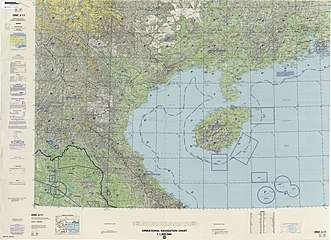
Historical maps of the border from west to east in the International Map of the World and Operational Navigation Chart, late 20th century:


References
- Nguyen, Hong Thao 2009.
- Anderson, James A. 2008, pp. 191-226.
- Lung Chang 1993, pp. 377–8.
- Yuk Wah Chan (12 November 2013). Vietnamese-Chinese Relationships at the Borderlands: Trade, Tourism and Cultural Politics. Routledge. p. 15. ISBN 978-1-134-49457-6.
- 程敏; 李V燕 (1 October 2014). 中国云南省与越南西北四省边境贸易研究. Beijing Book Co. Inc. p. 23. ISBN 978-7-5161-4883-9.
- http://www.baolaichau.vn/kinh-tế/khánh-thành-chợ-mậu-dịch-biên-giới-u-ma-tu-khoòng-bình-hà
- https://baolaichau.vn/kinh-tế/sức-hút-khu-kinh-tế-cử-khẩu-ma-lù-thàng
- Quyết định số 136/2009/QĐ-TTg ngày 26/11/2009 của Thủ tướng Chính phủ Việt Nam về việc thành lập Khu kinh tế cửa khẩu Thanh Thủy, tỉnh Hà Giang.
- https://giaoduc.net.vn/tieu-diem/quan-dan-soc-ha-doi-pho-ra-sao-voi-cac-thu-doan-gay-roi-cua-trung-quoc-sau-1979-post195516.gd
- http://en.gxzf.gov.cn/2019-07/05/c_406552.htm
- http://caobangtv.vn/tin-tuc-n29101/hoat-dong-xuat-nhap-khau-tai-cua-khau-tra-linh-po-peo-giam-manh.html
- http://www.mt.gov.vn/vn/tin-tuc/61931/cao-bang--can-dau-tu-nang-cap-duong-tinh-213.aspx
- https://nongnghiep.vn/cao-bang-xe-hang-mac-ket-nhieu-km-duong-vao-cua-khau-ly-van-d233934.html
- http://news.chinhphu.vn/Home/Financial-aid-for-construction-of-Ta-LungShuikou-2-Bridge-approved/20169/28447.vgp
- https://vnexpress.net/mo-lai-loat-cua-khau-voi-trung-quoc-4098593.html
- http://finance.sina.com.cn/roll/20050125/10121319952.shtml
- http://www.dianping.com/shop/121621130
- http://gx.people.com.cn/n2/2016/0530/c179430-28426481.html
- http://roll.sohu.com/20110921/n320029702.shtml
- https://vtv.vn/trong-nuoc/vu-no-sung-gay-roi-tai-cua-khau-bac-phong-sinh-2-chien-sy-bien-phong-viet-nam-hi-sinh-136296.htm
- http://www.baoquangninh.com.vn/kinh-te/201712/cong-bo-mo-loi-mo-po-hen-viet-nam-than-san-trung-quoc-2366279/
Bibliography
Anderson, James A. (2008). 'Treacherous Factions': Shifting Frontier Alliances in the Breakdown of Sino-Vietnamese Relations on the Eve of the 1075 Border War in Battlefronts Real and Imagined: War, Border, and Identity in the Chinese Middle Period]. New York.
Lung Chang (1993). Yueh-nan yu Chung-fa chan-cheng [越南與中法戰爭] [Vietnam and the Sino-French War]. Taipei.CS1 maint: ref=harv (link)
Nguyen, Hong Thao (2009). A line runs through it: Vietnam and China complete boundary marking process. Hanoi.