China–Nepal border
The border between China and Nepal is 1,414 kilometres (879 mi) in length along the mountain range the Himalayas and extends northwest-southeast direction, separating the south of Tibet Autonomous Region of China and the territory of Nepal. This border passes through the highest peak in the world, Mount Everest.
The boundaries of this particular border have changed dramatically over time, especially when considering relatively recent events such as the Annexation of Tibet in 1949. However, some of the most significant developments of modern times would be the signing of the "Agreement on Maintaining Friendly Relations between the People’s Republic of China and the Kingdom of Nepal" in 1956 and the "Sino-Nepalese Treaty of Peace and Friendship" in 1960, both of which formally recognised Tibet as a part of China and confirmed the limits of the countries of "China" and "Nepal" as they are known today.[1] [2]
The line extends between two tripoints Nepal–China–India. The tripoint in the west is near the Tinkar Pass in Sudurpashchim Pradesh[3] while that in the east is in the region of Mechi, Province No. 1, Nepal.
History
Throughout history, Nepalis traded with the Tibetans via the many border crossings. One of the most important goods traded was salt from the Tibetan areas.[4][5]
The border between Nepal and China is one of the most natural boundaries of the earth, due to the barrier Himalayas.
People's Republic of China and Kingdom of Nepal had a brief border dispute shortly before 1960.[6] They resolved this by officially signing a border agreement in 1961.[7]
While not disputed between Nepal and China, the western China–Nepal–India tripoint is disputed between Nepal and India. In 2015, the Nepalese parliament objected to the agreement between India and China to trade through Lipulekh stating that 'it violates Nepal's sovereign rights over the disputed territory'.[8] After the Indian prime minister's visit to China in 2015, India and China agreed to open a trading post in Lipulekh, raising objections from Nepal.[9][10] Nepal intended to resolve the issue via diplomatic means with India.[11]
Border crossings
In 2012, Nepal and China agreed to open new ports of entry, to a total of 6 official ports. Three of the ports are designated as international ports, while three others are only designated for bilateral trade.[12]
The border crossing between Zhangmu and Kodari on the Friendship Highway has been in operation since 1968.[13] In 2014, the border crossing at Rasuwa Fort (Rasuwagadhi) was opened for commerce.[4] However, this crossing is not open to foreigners until 2017.[14][15] In addition, this border crossing is being considered for a future rail crossing between the two countries.[16]
Other crossings like the one at Burang-Hilsa near the western tripoint while not widely accessible has been used for local trade between China and Nepal for many years.[17] Some of those crossings has gotten so important for local trade that in 2008 when Chinese tightened its border control during the Olympics, villages like Kimathanka faced food shortages due to disruption of local trade.[18] Historically, there are even more border crossings. The crossing at Kora La between Upper Mustang and Tibet for example was a major salt trade route. However, this crossing was closed due to Tibetan guerrillas in the 1960s. It remain closed for most of the year to this day, except when opening for limited local trade during the semiannual cross-border trade fairs.[4]
| Treaty Name[12](Other Name) | Jurisdictions[12] | Status | International Transit |
Crossing Location |
Border elevation |
Maximum inside T.A.R. |
Note |
|---|---|---|---|---|---|---|---|
| Burang–Yari (Xieerwa[19]) | Hilsa, Humla District Burang, Burang County |
Active | Planned | 30°09′12″N 81°20′00″E | 3,640 m (11,900 ft) | 4,720 m (15,500 ft) | Local trade currently exists |
| Lizi—Nechung (Kora La) | Lo Manthang, Mustang District Zhongba County |
Planned | No | 29°19′24″N 83°59′09″E | 4,620 m (15,200 ft) | Seasonal trade fair currently exists | |
| Gyirong–Rasuwa | Rasuwa Gadhi, Rasuwa District Gyirong, Gyirong County |
Active | Yes | 28°16′45″N 85°22′43″E | 1,850 m (6,100 ft) | 5,230 m (17,200 ft) | |
| Zhangmu–Kodari | Tatopani, Sindhupalchok District Zhangmu, Nyalam County |
Active[20] | Yes | 27°58′24″N 85°57′50″E | 1,760 m (5,800 ft) | 5,150 m (16,900 ft) | |
| Chentang–Kimathanka | Kimathanka, Sankhuwasabha District Chentang, Dinggyê County |
Planned | No | 27°51′30″N 87°25′30″E | 2,248 m (7,400 ft) | Local trade currently exists | |
| Ri'og–Olangchung Gola (Tipta La) | Olangchung Gola, Taplejung District Ri'og, Dinggyê County |
Planned | No | 27°49′00″N 87°44′00″E | 5,095 m (16,700 ft) | Local trade currently exists |
Galleries
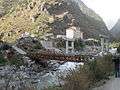 Crossing Bridge near the Rasuwa Fort Gyirong–Rasuwa crossing
 Sino-Nepal Friendship Bridge at the Zhangmu–Kodari crossing
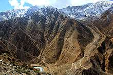 Nara La near the Burang–Hilsa crossing
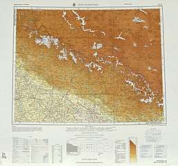
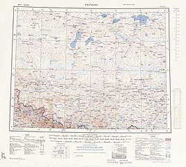
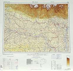
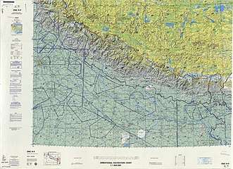
Historical maps of the border from west to east in the International Map of the World and Operational Navigation Chart, middle/late 20th century:
References
- Van Tronder, Gerry (2018). Sino-Indian War: Border Clash: October–November 1962. Pen and Sword Military. ISBN 9781526728388.
- Adhikari, Monalisa (2012). "Between the Dragon and the Elephant: Nepal's Neutrality Conundrum". Indian Journal of Asian Affairs. 25 (1/2): 85. JSTOR 41950522.
- Cowan, Sam (2015), The Indian checkposts, Lipu Lekh, and Kalapani, School of Oriental and African Studies, pp. 16–17
- Murton, Galen (March 2016). "A Himalayan Border Trilogy: The Political Economies of Transport Infrastructure and Disaster Relief between China and Nepal". Cross-Currents E-Journal. ISSN 2158-9674. Retrieved 2017-02-09.
- Eede, Joanna (2015-06-12). "Nomads of Dolpo". National Geographic Voices. National Geographic. Retrieved 2017-02-10.
- Office of the Geographer (1965): "The exact number of territorial disputes has never been ascertained, but as many as 20 sectors may have been involved. The most serious disputes were located at Rasu (north of Katmandu), Kimathanka in the east, Nara Pass, Tingribode near Mustang, Mount Everest, and the Nelu River. Most of these disputes were settled in favor of Nepal, although several favored China."
- Office of the Geographer (1965-05-30), International Boundary Study - China – Nepal Boundary (PDF), Bureau of Intelligence and Research, US Department of State, archived from the original (PDF) on 2012-05-03, retrieved 2017-02-14
- Nepal objects to India-China trade pact via Lipu-Lekh Pass, The Economic Times, 9 June 2015.
- "Resolve Lipu-Lekh Pass dispute: House panel to govt", Republica, 28 June 2018, archived from the original on 28 June 2018
- Ekantipur Report (July 9, 2015). "Lipulekh dispute: UCPN (M) writes to PM Koirala, Indian PM Modi & Chinese Prez Xi". Kathmandu Post. Retrieved 13 January 2020.
- "Post-J&K map ache spreads to Nepal". Telegraph India. 8 November 2019. Retrieved 15 November 2019.
- "中华人民共和国政府和尼泊尔政府关于边境口岸及其管理制度的协定" [China-Nepal Agreement on Port of Entry] (in Chinese). Chinese Embassy in Nepal. 2012-01-14. Retrieved 2017-02-10.
- Buddhi Narayan Shrestha (2015-11-29). "Nepal-China Seven Border Crossing-points". Border Nepal Buddhi. Retrieved 2017-02-09.
Kodari-Khasa has been in operation since 1968 for the transaction of trade and commerce. The second commercial border-point is the Rasuwagadhi-Kerung, which has come into use recently.
- Lobsang (2016-06-25). "Tibet Nepal Border Closed". The Land of Snows. Archived from the original on 2017-02-11. Retrieved 2017-02-09.
the new border crossing from Kyirong, Tibet to Rasuwaghadi, Nepal. Though this border crossing has NOT been opened to foreign travelers yet, this route has been open to traders from Nepal and China for much of the past year...
- Tenphel, Sonam. "Gyirong Port, new Sino-Nepal Border Finally was Opened, so Lhasa and Kathmandu Overland Tour is all Available Now". Tibet Vista. Retrieved 26 November 2017.
- "China Wants To Stretch Rail Network All The Way To Touch Bihar: Report". NDTV. 2016-05-24. Retrieved 2017-02-09.
A cross-border railroad link to the Rasuwagadhi area in Nepal has already been discussed between the two countries.
- Prithvi Man Shrestha; Jaya Bahadur Rokaya (2016-03-24). "Nepal, China rush to open Hilsa border". Kathmandu Post. Retrieved 2017-02-10.
Hilsa is one of the six border points Nepal and China had agreed to open for international trade when former Chinese Prime Minister Wen Jibao visited Kathmandu in 2012.
- Budhathoki, Kishor (2008-06-04). "China seals border, villages on Nepali side face starvation". The Himalayan Times. Retrieved 2017-02-13.
Starvation looms large in the northern parts of Sankhuwasabha district after China closed the Kimathanka check post
- "News from China" (PDF). Chinese Embassy in India. Vol. XXVIII no. 7. July 2016. Retrieved 2017-02-15.
- "Kodari Checkpoint To Open Today". The Spotlight Online. 2019-05-29. Retrieved 2019-06-28.
Bibliography
- Tiwary, Chitra K. (2012), "China–Nepal Border: Potential Hot Spot?", in Bruce Elleman; Stephen Kotkin; Clive Schofield (eds.), Beijing's Power and China's Borders: Twenty Neighbors in Asia, Taylor and Francis, pp. 205–, ISBN 9781317515647
External links
- [China-Nepal Border Agreement] (in Chinese). 1961-10-05 – via Wikisource.
| Wikimedia Commons has media related to China-Nepal border. |