Chamberaud
Chamberaud is a commune in the Creuse department in the Nouvelle-Aquitaine region in central France.
Chamberaud | |
|---|---|
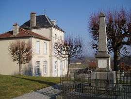 The town hall and war memorial in Chamberaud | |
Location of Chamberaud 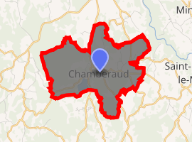
| |
 Chamberaud  Chamberaud | |
| Coordinates: 46°03′00″N 2°02′47″E | |
| Country | France |
| Region | Nouvelle-Aquitaine |
| Department | Creuse |
| Arrondissement | Guéret |
| Canton | Ahun |
| Intercommunality | CC Creuse Sud Ouest |
| Government | |
| • Mayor (2013–2014) | Michel GIRON |
| Area 1 | 7.44 km2 (2.87 sq mi) |
| Population (2017-01-01)[1] | 101 |
| • Density | 14/km2 (35/sq mi) |
| Time zone | UTC+01:00 (CET) |
| • Summer (DST) | UTC+02:00 (CEST) |
| INSEE/Postal code | 23043 /23480 |
| Elevation | 392–586 m (1,286–1,923 ft) (avg. 482 m or 1,581 ft) |
| 1 French Land Register data, which excludes lakes, ponds, glaciers > 1 km2 (0.386 sq mi or 247 acres) and river estuaries. | |
Geography
An area of lakes, forestry and farming comprising a small village and two hamlets, situated some 10 miles (16 km) northwest of Aubusson near the junction of the D55, D16 and the D79 roads.
Population
| Year | Pop. | ±% |
|---|---|---|
| 1962 | 110 | — |
| 1968 | 129 | +17.3% |
| 1975 | 96 | −25.6% |
| 1982 | 125 | +30.2% |
| 1990 | 113 | −9.6% |
| 1999 | 121 | +7.1% |
| 2008 | 111 | −8.3% |
Sights
- The church of St. Blaise, dating from the thirteenth century.
See also
References
- "Populations légales 2017". INSEE. Retrieved 6 January 2020.
External links
- Personal website about Chamberaud (in French)
| Wikimedia Commons has media related to Chamberaud. |
| Authority control |
|
|---|
This article is issued from Wikipedia. The text is licensed under Creative Commons - Attribution - Sharealike. Additional terms may apply for the media files.