Arfeuille-Châtain
Arfeuille-Châtain is a commune in the Creuse department in the Nouvelle-Aquitaine region in central France.
Arfeuille-Châtain | |
|---|---|
Location of Arfeuille-Châtain 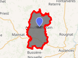
| |
 Arfeuille-Châtain  Arfeuille-Châtain | |
| Coordinates: 46°03′58″N 2°26′15″E | |
| Country | France |
| Region | Nouvelle-Aquitaine |
| Department | Creuse |
| Arrondissement | Aubusson |
| Canton | Évaux-les-Bains |
| Intercommunality | CC Marche et Combraille en Aquitaine |
| Government | |
| • Mayor (2008–2014) | Robert Servant |
| Area 1 | 20.5 km2 (7.9 sq mi) |
| Population (2017-01-01)[1] | 192 |
| • Density | 9.4/km2 (24/sq mi) |
| Time zone | UTC+01:00 (CET) |
| • Summer (DST) | UTC+02:00 (CEST) |
| INSEE/Postal code | 23005 /23700 |
| Elevation | 493–690 m (1,617–2,264 ft) (avg. 510 m or 1,670 ft) |
| 1 French Land Register data, which excludes lakes, ponds, glaciers > 1 km2 (0.386 sq mi or 247 acres) and river estuaries. | |
Geography
An area of lakes, forestry and farming comprising several hamlets situated some 14 miles (23 km) northeast of Aubusson at the junction of the D4 and the D27 roads.
Population
| Year | Pop. | ±% |
|---|---|---|
| 1962 | 258 | — |
| 1968 | 319 | +23.6% |
| 1975 | 246 | −22.9% |
| 1982 | 190 | −22.8% |
| 1990 | 167 | −12.1% |
| 1999 | 168 | +0.6% |
| 2008 | 178 | +6.0% |
Sights
- The churches in the two main villages, both dating from the seventeenth century.
References
- "Populations légales 2017". INSEE. Retrieved 6 January 2020.
External links
| Wikimedia Commons has media related to Arfeuille-Châtain. |
- Arfeuille-Châtain on the Quid website (in French)
| Authority control |
|
|---|
This article is issued from Wikipedia. The text is licensed under Creative Commons - Attribution - Sharealike. Additional terms may apply for the media files.