Beaty Crossroads, Alabama
Beaty Crossroads is an unincorporated community on Sand Mountain in northern DeKalb County, Alabama, United States.[1] It is located within the town limits of Ider at the intersection of Alabama Highway 75 and Alabama Highway 117.
Beaty Crossroads, Alabama | |
|---|---|
 Beaty Crossroads Location within Alabama | |
| Coordinates: 34°41′44″N 085°40′10″W [1] | |
| Country | United States |
| State | Alabama |
| County | DeKalb |
| Elevation | 1,601 ft (488 m) |
| Time zone | UTC-6 (Central (CST)) |
| • Summer (DST) | UTC-5 (CDT) |
| ZIP code | 35981 |
| Area code(s) | 256 |
| GNIS ID[1] | 150083 |
History
It is believed Beaty Crossroads was named after Oliver Beaty, teacher and founder of the nearby Beaty School.[2]
Geography
Adamsburg is located at 34°41′44″N 085°40′10″W. Its average elevation is 1,601 feet (488 m) above sea level.[1]
References
- "Feature Detail Report for: Beaty Crossroads (DeKalb County, Alabama)". Geographic Names Information System. United States Geological Survey. Retrieved January 8, 2013.
- Foscue, Virginia. Place Names in Alabama. University: U of Alabama Press, 1989.
Municipalities and communities of DeKalb County, Alabama, United States | ||
|---|---|---|
| Cities | 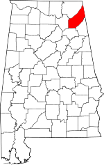 Map of Alabama highlighting DeKalb County | |
| Towns | ||
| Unincorporated communities | ||
| Ghost towns | ||
| Footnotes | ‡This populated place also has portions in an adjacent county or counties | |
This article is issued from Wikipedia. The text is licensed under Creative Commons - Attribution - Sharealike. Additional terms may apply for the media files.