Balaoan
Balaoan, officially the Municipality of Balaoan (Ilocano: Ili ti Balaoan; Filipino: Bayan ng Balaoan), is a 1st class municipality in the province of La Union, Philippines. According to the 2015 census, it has a population of 39,188 people.[3]
Balaoan | |
|---|---|
| Municipality of Balaoan | |
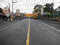 Balaoan town center | |
 Seal | |
| Nickname(s): The Sea Urchin Capital of the North | |
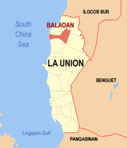 Map of La Union with Balaoan highlighted | |
OpenStreetMap 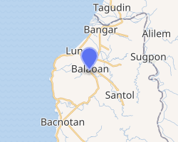
| |
.svg.png) Balaoan Location within the Philippines | |
| Coordinates: 16°49′N 120°24′E | |
| Country | |
| Region | Ilocos Region (Region I) |
| Province | La Union |
| District | 1st District |
| Barangays | 36 (see Barangays) |
| Government | |
| • Type | Sangguniang Bayan |
| • Mayor | Aleli U. Concepcion |
| • Vice Mayor | Al-fred O. Concepcion |
| • Congressman | Pablo C. Ortega |
| • Electorate | 25,369 voters (2019) |
| Area | |
| • Total | 68.70 km2 (26.53 sq mi) |
| Population (2015 census)[3] | |
| • Total | 39,188 |
| • Density | 570/km2 (1,500/sq mi) |
| • Households | 8,697 |
| Economy | |
| • Income class | 1st municipal income class |
| • Poverty incidence | 6.51% (2015)[4] |
| • Revenue (₱) | |
| • Assets (₱) | |
| • Expenditure (₱) | |
| Time zone | UTC+8 (PST) |
| ZIP code | 2517 |
| PSGC | |
| IDD : area code | +63 (0)72 |
| Climate type | tropical monsoon climate |
| Native languages | Ilocano Tagalog |
| Website | www |
Geography
Balaoan is situated north of Bacnotan, south of Bangar, east of Luna and west of Santol. Located 30 kilometres (19 mi) north of San Fernando City, the provincial capital of La Union and the regional capital of Region I. Balaoan is 299 kilometres (186 mi) north of Metro Manila. Barangay Paraoir is Balaoan's pristine coastal community on the South China Sea.
Balaoan can be reached from Manila using the MacArthur Highway, or by airplane via Canaoay Airport in San Fernando City.
Its land area of 6,870 hectares (17,000 acres) consists mostly of agricultural lands. It occupies 4.3% of the total area of the province.
Climate
| Climate data for Balaoan, La Union | |||||||||||||
|---|---|---|---|---|---|---|---|---|---|---|---|---|---|
| Month | Jan | Feb | Mar | Apr | May | Jun | Jul | Aug | Sep | Oct | Nov | Dec | Year |
| Average high °C (°F) | 30 (86) |
31 (88) |
33 (91) |
33 (91) |
32 (90) |
31 (88) |
30 (86) |
30 (86) |
30 (86) |
31 (88) |
31 (88) |
31 (88) |
31 (88) |
| Average low °C (°F) | 21 (70) |
22 (72) |
23 (73) |
25 (77) |
26 (79) |
26 (79) |
26 (79) |
25 (77) |
25 (77) |
24 (75) |
23 (73) |
22 (72) |
24 (75) |
| Average precipitation mm (inches) | 42 (1.7) |
48 (1.9) |
74 (2.9) |
110 (4.3) |
269 (10.6) |
275 (10.8) |
362 (14.3) |
325 (12.8) |
330 (13.0) |
306 (12.0) |
126 (5.0) |
61 (2.4) |
2,328 (91.7) |
| Average rainy days | 11.2 | 12.0 | 17.1 | 21.2 | 27.1 | 26.8 | 28.1 | 27.0 | 26.0 | 24.5 | 17.7 | 12.4 | 251.1 |
| Source: Meteoblue [5] | |||||||||||||
Barangays
Balaoan is politically subdivided into 36 barangays. [2]
- Almeida
- Antonino
- Apatut
- Ar-arampang
- Baracbac Este
- Baracbac Oeste
- Bet-ang
- Bulbulala
- Bungol
- Butubut Este
- Butubut Norte
- Butubut Oeste
- Butubut Sur
- Cabuaan
- Calliat
- Calungbuyan
- Camiling
- Dr. Camilo Osias
- Guinaburan
- Masupe
- Nagsabaran Norte
- Nagsabaran Sur
- Nalasin
- Napaset
- Pa-o
- Pagbennecan
- Pagleddegan
- Pantar Norte
- Pantar Sur
- Paraoir
- Patpata
- Sablut
- San Pablo
- Sinapangan Norte
- Sinapangan Sur
- Tallipugo
History
According to William Scott, "Balaoan itself was an emporium for the exchange of Igorot gold."[6]
Balaoan, formerly "Puraw" (meaning "white') was originally part of Ilocos Sur. The town's present name originated during the Spanish colonial era. A group of Spanish soldiers were on patrol and went on to rest on a sitio. The villagers were curious about the soldiers because of their unusual descent and fair skin color. They flocked the soldiers touching their guns, too afraid that the guns might explode accidentally, one villager asked the soldier in a local vernacular.. "Aoan bala?" (meaning "No bullets?"). The soldier did not understand what the villager meant, he uttered the last word first, and remembering the last, he said "Bala-aoan".
During the Spanish colonization of the Philippines, a secret society of insurrectos was organized in the municipality. Its purpose was to fight and revolt against the Spanish Government in the area. On the eve of the revolution, a traitor told the Spanish of their plan. The Spanish soldiers, without any investigation arrested seven members of the secret society, and executed them the same night. Only one, Fernando Ostrea, escaped with leg wounds. He informed the people about what has happened. In memory of the seven Martyrs, a masonic lodge, Siete Martires Lodge No. 177, was organized.
Balaoan is one of the oldest municipalities in La Union, having been founded in 1704. Its first Capitan is Ignacio Duldulao.
Demographics
|
| ||||||||||||||||||||||||||||||||||||||||||||||||
| Source: Philippine Statistics Authority[3][7][8][9] | |||||||||||||||||||||||||||||||||||||||||||||||||
In the 2015 census, the population of Balaoan was 39,188 people,[3] with a density of 570 inhabitants per square kilometre or 1,500 inhabitants per square mile.
The dominant language spoken in Balaoan is Ilocano.
Festivities
The church of Balaoan is under the advocacy of the town's patron saint, St. Nicholas of Tolentino, whose feast day is celebrated on September. Balaoan's town fiesta is celebrated every December 21 to 23 of the year.
Education
Elementary schools
- Almeida Elementary School
- Apatut Elementary School (Apatut)
- Ar-arampang Elementary School (Ar- Arampang,Balaoan)
- Balaoan Central Elementary School (Antonino and Cabua-an)
- Balaoan Christian Foundation (Nalasin)
- Bulbulala Elementary School (Bulbulala)
- Bungol Elementary School (Bungol)
- Butubut Elementary School (Butubut Sur)
- Butubut Norte Elementary School (Butubut Norte)
- Calliat Elementary School (Calliat)
- Guinaburan Elementary School (Guinaburan)
- Masupe Elementary School (Masupe)
- Nagsabaran Sur Elementary School (Nsgsabaran Sur)
- Osias Educational Foundation (Dr. Camilo Osias)
- Pantar Community School (Pantar Norte)
- Pantar Sur Elementary School (Pantar Sur)
- Paraoir Elementary School (Paraoir)
- Patpata Elementary School (Patpata)
- San Nicolas Academy
- San Nicolas Academy (Dr. Camilo Osias, Nalasin and Antonino)
- Sinapangan National High School (Sinapangan Norte)
- Sinapangan Norte Elementary School (Sinapangan Norte)
- Sinapangan Sur Elementary School (Sinapangan Sur)
High schools
- Bungol National High School (Bungol)
- Butubut National High School (Butubut Norte)
- Castor Z. Concepcion Memorial National High School (Nalasin and Antonino)
- Don Mariano Marcos Memorial State University National High School (Paraoir)
- Osias Educational Foundation (Dr. Camilo Osias)
- San Nicolas Academy
Notable people from Balaoan
- Camilo Osías, former Senator
- Magnolia Antonino, former Senator
Gallery
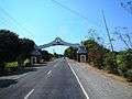 Welcome arch
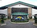 Municipal hall
 Public market
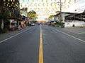 Street view
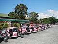 Tricycle terminal
References
- "Municipality". Quezon City, Philippines: Department of the Interior and Local Government. Retrieved 31 May 2013.
- "Province: La Union". PSGC Interactive. Quezon City, Philippines: Philippine Statistics Authority. Retrieved 12 November 2016.
- Census of Population (2015). "Region I (Ilocos Region)". Total Population by Province, City, Municipality and Barangay. PSA. Retrieved 20 June 2016.
- "PSA releases the 2015 Municipal and City Level Poverty Estimates". Quezon City, Philippines. Retrieved 1 January 2020.
- "Balaoan: Average Temperatures and Rainfall". Meteoblue. Retrieved 26 April 2020.
- Scott, William (1974). The Discovery of the Igorots. Quezon City: New Day Publishers. p. 58. ISBN 9711000873.
- Census of Population and Housing (2010). "Region I (Ilocos Region)". Total Population by Province, City, Municipality and Barangay. NSO. Retrieved 29 June 2016.
- Censuses of Population (1903–2007). "Region I (Ilocos Region)". Table 1. Population Enumerated in Various Censuses by Province/Highly Urbanized City: 1903 to 2007. NSO.
- "Province of La Union". Municipality Population Data. Local Water Utilities Administration Research Division. Retrieved 17 December 2016.
External links
| Wikimedia Commons has media related to Balaoan, La Union. |
- Balaoan Profile at PhilAtlas.com
- Philippine Standard Geographic Code
- Philippine Census Information
- Local Governance Performance Management System
Places adjacent to Balaoan | ||||||||||
|---|---|---|---|---|---|---|---|---|---|---|
| ||||||||||