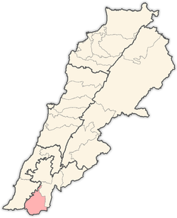
Yater
Yater (Arabic: ياطر) is a Lebanese municipality located in Bint Jbeil District. It is 112 kilometers away from Beirut.[1]
Yater ياطر | |
|---|---|
Village | |
 Yater Location within Lebanon | |
| Coordinates: 33°9′14″N 35°19′43″E | |
| Grid position | 181/284 PAL |
| Country | |
| Governorate | Nabatieh Governorate |
| District | Bint Jbeil District |
| Area | |
| • Total | 8.32 km2 (3.21 sq mi) |
| Elevation | 710 m (2,330 ft) |
| Time zone | UTC+2 (EET) |
| • Summer (DST) | UTC+3 (EEST) |
| Website | http://www.yatar.net/ |
E. H. Palmer wrote that the name Yater came from a personal name.[2]
History
In 1852, Edward Robinson visited and found "some few remains of antiquity", including two excavated chambers at the south of the village.[3]
In 1875 Victor Guérin found Yater to have 160 Metawileh inhabitants.[4] He further said that the ancient name of Yater must have been Yattir or Jether; "Two other rocky hills, situated, the first to the south, the second to the south-west of this village, served as cemeteries to the ancient city. All the stones with which it was built were taken from this place. Vast quarries, cisterns, presses, and tombs, have been cut in the sides and on the summits of these hills, which are separated by a narrow valley. The greater contained each nine loculi, grouped three to left, and at the end under a vaulted arcosolium. The facade of two among them is pierced by several small niches, some designed for simple lamps, others for statuettes. One of these caves seems to have been set aside for some sacred purpose."[5]
According to the SWP: "There are three rock-cut tombs, with side loculi and kokim, at this village; one of these has an olive-press inside. The rock is much quarried round, and the place has the appearance of having been an ancient site. There is also a rock-cut wine-press and ruined birkeh. To the north-west there are two ruined watch-towers, with rough-hewn stones. To the north there is another similar, with a cistern."[6]
In 1881, the PEF's Survey of Western Palestine (SWP) described it as: "A stone village, containing about 300 Metawileh, situated on hill-top, with olives and arable land about, having a birket and many cisterns and a spring near it."[7]
The village once marked the northernmost extent of Jewish settlement upon their return from Babylonian exile in the 4th century BCE, and is mentioned in the 3rd century Mosaic of Rehob.[8]
References
- Localiban. "Yater - Localiban". www.localiban.org. Retrieved 2020-06-03.
- Palmer, 1881, p. 104
- Robinson and Smith, 1856, pp. 61-62
- Guerin, 1880, pp. 413-4
- Guerin, 1880, pp. 413-4; in Conder and Kitchener, 1881, SWP I, p. 260
- Conder and Kitchener, 1881, SWP I, p. 260
- Conder and Kitchener, 1881, SWP I, p. 203
- Frankel, R. & Finkelstein, I. (1983), p. 44
Bibliography
- Conder, C.R.; Kitchener, H.H. (1881). The Survey of Western Palestine: Memoirs of the Topography, Orography, Hydrography, and Archaeology. 1. London: Committee of the Palestine Exploration Fund.
- Frankel, Raphael; Finkelstein, I. (1983). "'The Northwest Corner of Eretz-Israel' in the Baraita 'Boundaries of Eretz-Israel'". Cathedra: For the History of Eretz Israel and its Yishuv. 27 (27): 39–46. JSTOR 23398920.
- Guérin, Victor (1880). Description Géographique Historique et Archéologique de la Palestine (in French). 3: Galilee, pt. 2. Paris: L'Imprimerie Nationale.
- Palmer, E. H. (1881). The Survey of Western Palestine: Arabic and English Name Lists Collected During the Survey by Lieutenants Conder and Kitchener, R. E. Transliterated and Explained by E.H. Palmer. Committee of the Palestine Exploration Fund.
- Robinson, E.; Smith, E. (1856). Later Biblical Researches in Palestine and adjacent regions: A Journal of Travels in the year 1852. London: John Murray.
External links
- Survey of Western Palestine, Map 4: IAA, Wikimedia commons
- Yater, Localiban
