Bint Jbeil
Bint Jbeil (Arabic: بنت جبيل) is the second largest town in the Nabatiye Governorate in Southern Lebanon.
Bint Jbeil بنت جبيل | |
|---|---|
 | |
 Bint Jbeil | |
| Coordinates: 33°07′N 35°26′E | |
| Grid position | 190/280 PAL |
| Country | |
| Governorate | Nabatieh Governorate |
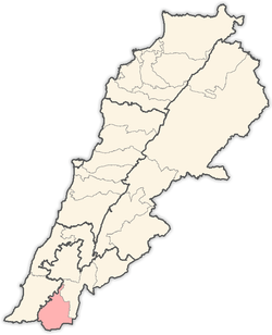
| District | Bint Jbeil District |
| Area | |
| • Total | 9.10 km2 (3.51 sq mi) |
| Population (2001) | |
| • Total | 30,000 |
The town has an estimated population of 30,000. Its exact population is unknown, because Lebanon has not conducted a population census since 1932.[1]
History
The area around Bint Jbeil has been inhabited for millennia. Archaeologists have suggested that the ancient fortified city of En-hazor.[2]
Historians claim that the founders of Bint Jbeil were the Phoenicians, who came from the northern Lebanese town of Byblos (Jbeil); they may have been Shia Muslims escaping the Mamluk occupation of Byblos. Bint Jbeil literally means "daughter of Byblos".
According to E. H. Palmer, the name means "The daughter of the mother of the little mountain".[3]
Ottoman era
In 1596, it was named as a village, "Bint Jubayl" in the Ottoman nahiya (subdistrict) of Tibnin under the liwa' (district) of Safad, with a population of 238 households and 60 bachelors, all Muslim. The villagers paid taxes on agricultural products, such as wheat, barley, olive trees, fruit trees, goats and beehives, in addition to "occasional revenues”, a press for olive oil or grape syrup, and a fixed sum; a total of 25,220 akçe.[4][5]
In 1838 Edward Robinson noted it as a large Shia village,[6] while in 1875, Victor Guérin found it to be a village with one thousand Metualis.[7]
In 1881, the PEF's Survey of Western Palestine (SWP) described it: "A very large Metawileh village, containing about 1,100 to 1,500 Metawileh. A market is held here every Thursday. The village is well built, and has a mosque. The situation is surrounded by higher hills, though the village is on high ground. The cultivation around is grapes, olives, and arable land. Water is supplied from a spring and many cisterns and large birket."[8]
Modern era

The town is predominately inhabited by Shia Muslims (90%), though the surrounding area also has a significant Christian (10%) minority.
Bint Jbeil was occupied by Israel in 1978 during Operation Litani, and again from 1982 until 2000 during the 1982-2000 South Lebanon conflict, when it was severely depopulated; as much as 75% of the population was reported to have left for other parts of Lebanon.[9] It was the scene of occasional attacks on the Israeli military forces, such as a car bombing carried out by a Hezbollah member on 25 April 1995.[10] Hezbollah took control of the town following the Israeli withdrawal from South Lebanon.

As the largest town in the area, Bint Jbeil is sometimes known as the "Capital of the Liberated South" (among Lebanese Shi'ites). It is considered one of the centers with symbolic history for Hezbollah.[11] Under Lebanon's complicated system of sectarian electoral representation, the Bint Jbeil electoral district is allocated 3 Shi'ite seats in the country's parliament.[12] Hezbollah did well in the area in the 2005 elections in Lebanon, winning the local seats to add to its nationwide tally of 14.
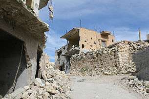
Bint Jbeil was again contested by Israeli and Hezbollah forces in the 2006 Israel-Lebanon conflict, during which it suffered heavy damage (See Battle of Bint Jbeil). On July 15, Israeli missile killed 4 civilians, aged between 60 and 85.[13]
Reconstruction as of early 2007 had been going very slowly, leading to reports of dissatisfaction among the residents.[14] Iranian President Mahmoud Ahmadinejad visited the town in 2010 to show solidarity for Hezbollah and the local victims of Israel's attacks.[15]
Notable people
- Ali Ahmad Bazzi, MP,
- Khalid Bazzi (1969 - 2006)
News articles
- "IDF in control of Bint Jbeil" - Ynet Israel News, Article Published: 07.25.06
- "Israeli Soldiers in Stiff Fight for Village" - NPR, Article Published: 07.26.06
- "Battle of Bint Jbeil shocks ground troops" - Irish Independent, Article Published: 07.27.06
- "Israelis withdraw from Hizbollah border stronghold" - The Guardian, Article Published: 07.29.06
- "Surveying the Damage in Bint Jbeil" - TIME, Article Published: 08.01.06
- "The old and sick emerge to discover only rubble" - The Telegraph, Article Published: 08.01.06
- Israel Troops Killed in Bint Jbeil - Ynet Israel News, Article Published: 08.07.06
- Report: “Several soldiers killed after requested to take photos faking capture of Lebanese town” - IMEMC, Article Published: 10.26.06
See also
References
- "Archived copy". Archived from the original on 2013-01-17. Retrieved 2013-01-17.CS1 maint: archived copy as title (link)
- Freedman, et. al, 2000, p. 407
- Palmer, 1881, p. 68
- Hütteroth and Abdulfattah, 1977, p. 179
- Note that Rhode, 1979, p. 6 writes that the register that Hütteroth and Abdulfattah studied was not from 1595/6, but from 1548/9
- Robinson and Smith, 1841, vol 3, pp. 372-373
- Guérin, 1880, pp. 108-109
- Conder and Kitchener, 1881, SWP I, p. 201
- "The Situation in Lebanon, July 1989", hearing before the Committee on Foreign Affairs Subcommittee on Europe and the Middle East
- Ami Pedahzur, Suicide Terrorism, p. 127. Blackwell Publishing, 2005
- "Bint Jbeil: Hezbollah heartland". BBC News. 27 July 2006.
- The Middle East, Central Asia and South Asia, ed. Dieter Nohlen, Florian Grotz, Christof Hartmann, p. 179. Oxford University Press, 2002
- HRW, 2007, pp. 89-91
- Vision of Rebuilding Lebanon Wanes, Hassan M. Fattah, New York Times, January 22, 2007
- MacLeod, Hugh (14 October 2010). "Hezbollah gives Ahmadinejad a hero's welcome in southern Lebanon". The Guardian. London.
Bibliography
- Conder, C.R.; Kitchener, H.H. (1881). The Survey of Western Palestine: Memoirs of the Topography, Orography, Hydrography, and Archaeology. 1. London: Committee of the Palestine Exploration Fund.
- Freedman, D.N.; Astrid B Beck; Allen C Myers, eds. (2000). Eerdmans Dictionary of the Bible. Amsterdam University Press. ISBN 9053565035.
- Guérin, V. (1880). Description Géographique Historique et Archéologique de la Palestine (in French). 3: Galilee, pt. 2. Paris: L'Imprimerie Nationale.
- HRW (2007). Why They Died: Civilian Casualties in Lebanon During the 2006 War. Human Rights Watch.
- Hütteroth, Wolf-Dieter; Abdulfattah, Kamal (1977). Historical Geography of Palestine, Transjordan and Southern Syria in the Late 16th Century. Erlanger Geographische Arbeiten, Sonderband 5. Erlangen, Germany: Vorstand der Fränkischen Geographischen Gesellschaft. ISBN 3-920405-41-2.
- Palmer, E.H. (1881). The Survey of Western Palestine: Arabic and English Name Lists Collected During the Survey by Lieutenants Conder and Kitchener, R. E. Transliterated and Explained by E.H. Palmer. Committee of the Palestine Exploration Fund.
- Rhode, H. (1979). Administration and Population of the Sancak of Safed in the Sixteenth Century. Columbia University.
- Robinson, E.; Smith, E. (1841). Biblical Researches in Palestine, Mount Sinai and Arabia Petraea: A Journal of Travels in the year 1838. 3. Boston: Crocker & Brewster.
External links
- Survey of Western Palestine, Map 4: IAA, Wikimedia commons
- Bent Jbayl, Localiban
- Unofficial Website of Bint Jbeil
- Unofficial Website of Bint Jbeil-Arabic
- Population Estimate of Bint Jbeil
