Wuyuan County, Jiangxi
Wuyuan County (simplified Chinese: 婺源县; traditional Chinese: 婺源縣; pinyin: Wùyuán Xiàn) is a county in the northeast of Jiangxi province, People's Republic of China, bordering the provinces of Zhejiang to the east and Anhui to the north. It is under the jurisdiction of the prefecture-level city of Shangrao.
Wuyuan 婺源县 | |
|---|---|
County | |
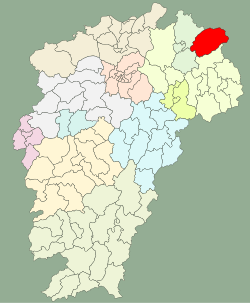 location in Jiangxi | |
| Coordinates: 29°14′53″N 117°51′43″E | |
| Country | People's Republic of China |
| Province | Jiangxi |
| Prefecture-level city | Shangrao |
| Time zone | UTC+8 (China Standard) |
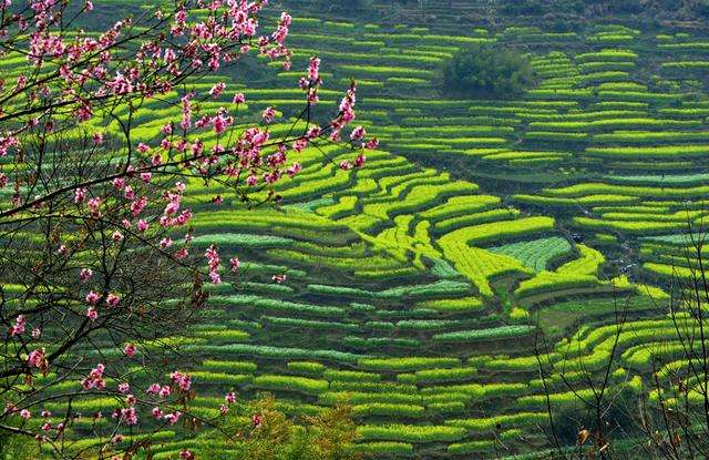
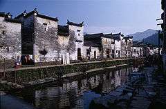
Wuyuan, on the boundary of three provinces in Jiangxi's northeastern corner, has a landscape dotted with strange caves, deep secluded rocks and numerous historic sites. Wuyuan County is home to some of the best-preserved ancient architecture in China. Wuyuan's structures were built in 740 during the Tang Dynasty, its remoteness and inconvenient transportation protecting its villages from too many visitors.
Demographics
The population of the district was 334,020 in 2010.[1]
Culture
The dialect of Wuyuan county is of the Hui dialects, and its culture closely resembles that of Huizhou in southern Anhui.
Economy
The GDP of Wuyuan in 2011 is 5.622 billion yuan (RMB).
Transportation
- Railway: Hefei–Fuzhou High-Speed Railway
- Highway: G56 Hangzhou–Ruili Expressway, S22 Dexing–Wuyuan Expressway
Climate
| Climate data for Wuyuan (1981−2010) | |||||||||||||
|---|---|---|---|---|---|---|---|---|---|---|---|---|---|
| Month | Jan | Feb | Mar | Apr | May | Jun | Jul | Aug | Sep | Oct | Nov | Dec | Year |
| Record high °C (°F) | 25.4 (77.7) |
29.1 (84.4) |
35.6 (96.1) |
34.3 (93.7) |
35.7 (96.3) |
37.5 (99.5) |
39.6 (103.3) |
40.1 (104.2) |
38.8 (101.8) |
37.9 (100.2) |
32.6 (90.7) |
25.4 (77.7) |
40.1 (104.2) |
| Average high °C (°F) | 10.8 (51.4) |
12.9 (55.2) |
16.8 (62.2) |
22.9 (73.2) |
27.7 (81.9) |
30.0 (86.0) |
33.7 (92.7) |
33.7 (92.7) |
30.2 (86.4) |
25.2 (77.4) |
19.5 (67.1) |
13.8 (56.8) |
23.1 (73.6) |
| Daily mean °C (°F) | 5.3 (41.5) |
7.5 (45.5) |
11.2 (52.2) |
17.0 (62.6) |
21.7 (71.1) |
24.9 (76.8) |
28.0 (82.4) |
27.8 (82.0) |
24.1 (75.4) |
18.6 (65.5) |
12.4 (54.3) |
6.8 (44.2) |
17.1 (62.8) |
| Average low °C (°F) | 1.8 (35.2) |
3.9 (39.0) |
7.4 (45.3) |
12.8 (55.0) |
17.4 (63.3) |
21.2 (70.2) |
23.9 (75.0) |
23.7 (74.7) |
19.9 (67.8) |
14.1 (57.4) |
7.8 (46.0) |
2.4 (36.3) |
13.0 (55.4) |
| Record low °C (°F) | −7.9 (17.8) |
−6.6 (20.1) |
−5.9 (21.4) |
0.7 (33.3) |
9.3 (48.7) |
12.0 (53.6) |
18.6 (65.5) |
17.3 (63.1) |
10.4 (50.7) |
0.7 (33.3) |
−4.6 (23.7) |
−9.1 (15.6) |
−9.1 (15.6) |
| Average precipitation mm (inches) | 82.4 (3.24) |
127.1 (5.00) |
205.0 (8.07) |
246.6 (9.71) |
261.2 (10.28) |
363.2 (14.30) |
241.4 (9.50) |
127.6 (5.02) |
84.4 (3.32) |
68.5 (2.70) |
76.2 (3.00) |
53.5 (2.11) |
1,937.1 (76.25) |
| Average relative humidity (%) | 82 | 82 | 83 | 82 | 82 | 85 | 82 | 81 | 81 | 80 | 81 | 80 | 82 |
| Source: China Meteorological Data Service Center[3] | |||||||||||||
Scenic Sites
- Wuyuan Huangling Tourism Resort
 Likeng, Tuochuan
 Jiangling
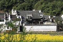 Huangcun, Dazhangshan
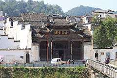 Wangkou
 Caihong Bridge, Qinghua Town
 Likeng, Qiukou
 Jiangwan
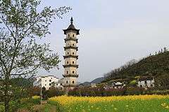 Longtian Pagoda
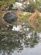
Notes and references
- 婺源县统计局. 婺源县第六次全国人口普查主要数据公报. 上饶统计信息网.
- 婺源县建国60年主要经济数据
- 中国地面气候标准值月值(1981-2010) (in Chinese). China Meteorological Data Service Center. Retrieved 10 October 2019.
External links
| Wikivoyage has a travel guide for Wuyuan. |
| Wikimedia Commons has media related to Wuyuan County, Jiangxi. |
- (in Chinese) Government site - Google translation
- Wyly.org
| Authority control |
|
|---|