Wurdi Youang
Wurdi Youang is an Aboriginal stone arrangement located off the Little River – Ripley Road at Mount Rothwell, near Little River, Victoria in Australia.[1] The site was acquired by the Indigenous Land Corporation on 14 January 2000 and transferred to the Wathaurong Aboriginal Co-operative on 17 August 2006.[2]
Description
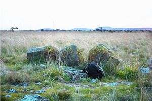
The stone arrangement takes the form of an irregular egg-shape or ovoid about 50 m (164 ft) in diameter with its major axis aligning east-west.[3] It is composed of about 100 basalt stones, ranging from small rocks about 200 mm (8 in) in diameter to standing stones about 1 m (3 ft) high with an estimated total mass of about 23 t (23 long tons).[4] There are three prominent waist-high stones, at its western end, which is the highest point of the ring. The purpose, use, and age of the arrangement are not known.[5] The purpose of the site may be ceremonial in nature as with many other stone arrangements in southeastern Australia.[6]
The site is recorded on the Victorian Aboriginal Heritage Register, the Victorian Heritage Register (H1107), and the City of Greater Geelong Planning Scheme Heritage Overlay (HO294).[7]
Astronomical hypothesis
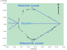
A series of stones, located to the west of the arrangement's western apex, mark the positions of the setting sun at the equinoxes and solstices.[8] A survey study shows that these alignments are accurate to within a few degrees. Additionally, the straight sides of the arrangement, which diverge from its eastern apex, also indicate the setting position of the sun at the solstices to within a few degrees and at the equinoxes the sun sets over the three prominent stones at the apex.[3]
It has been suggested by scientists studying the arrangements that it could be as old as 11,000 years (based on carbon dating at nearby sites),[9] which would make it the oldest astronomical observatory in the world.[10] However, the age of the arrangement is not known.
References
- "Wurdi Youang, Australia". Portal to the Heritage of Astronomy. UNESCO. Archived from the original on 17 September 2015. Retrieved 17 October 2016.
- Indigenous Land Corporation, Annual Report 2006–2007 ILC October 2007, ISSN 1325-3395
- Norris, R.P.; Norris, P.M.; Hamacher, D.W.; Abrahams, R. (2013). "Wurdi Youang: an Australian Aboriginal stone arrangement with possible solar indications". Rock Art Research. 30 (1): 55–65.
- Ray Norris et al 2008, ICOMOS–IAU Thematic Study on Astronomical Heritage
- Hamacher, D.W. & Norris, R.P. (2011). "Bridging the Gap" through Australian Cultural Astronomy. In 'Archaeoastronomy & Ethnoastronomy: building bridges between cultures', Proceedings of IAU Symposium No. 278 held in Lima, Peru from 5–14 January 2011, edited by Clive Ruggles. Cambridge University Press, pp. 282–290.
- Lane, L. and Fullagar, R. (1980) Previously unrecorded Aboriginal stone alignments in Victoria. Records of the Victoria Archaeological Survey, No. 10, pp. 134–151
- Victorian Heritage Database, Mt Rothwell Archaeological Site (Gaz. 120.8-12-1974 p. 4300) (See also Ripley Road)
- Morieson, J. (2008). "The case study of the Boorong", in Jonas Vaiškūnas (ed.), Astronomy and Cosmology in Folk Traditions and Cultural Heritage, pp. 258–262. Klaipeda: Klaipeda University Press (Archaeologia Baltica 10).
- "Rock of ages in state's southwest". Quarry. Gunnamatta Media. 1 March 2013. Retrieved 28 October 2016., citing the Geelong Advertiser.
- Hamish Fitzsimmons (12 October 2016). "The world's oldest observatory? How Aboriginal astronomy provides clues to ancient life". Australian Broadcasting Corporation. Retrieved 12 October 2016.
Further reading
- Mountford, C.P. (1927). "Aboriginal stone structures in South Australia", Transactions and Proceedings of the Royal Society of South Australia 51, 169–172.
- Mountford, C.P. (1976). Nomads of the Australian Desert. Adelaide: Rigby.