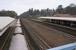
Winchfield railway station
Winchfield railway station is located in the small village of Winchfield and also serves Hartley Wintney and surrounding villages and towns such as Odiham and Whitehall in Hampshire, England.
| Winchfield | |
|---|---|
 Winchfield railway station seen from the bridge | |
| Location | |
| Place | Winchfield |
| Local authority | District of Hart |
| Coordinates | 51.285°N 0.907°W |
| Grid reference | SU763545 |
| Operations | |
| Station code | WNF |
| Managed by | South Western Railway |
| Number of platforms | 2 |
| DfT category | D |
| Live arrivals/departures, station information and onward connections from National Rail Enquiries | |
| Annual rail passenger usage* | |
| 2014/15 | |
| 2015/16 | |
| 2016/17 | |
| 2017/18 | |
| 2018/19 | |
| History | |
| Original company | London and Southampton Railway |
| Pre-grouping | London and South Western Railway |
| Post-grouping | Southern Railway |
| 24 September 1838 | Opened as Shapley Heath |
| by November 1840 | Renamed Winchfield |
| National Rail – UK railway stations | |
| * Annual estimated passenger usage based on sales of tickets in stated financial year(s) which end or originate at Winchfield from Office of Rail and Road statistics. Methodology may vary year on year. | |
It is 39 miles 66 chains (64.1 km) down the main line from London Waterloo[note 1] and is situated between Fleet and Hook. Trains typically run every 30 minutes between Waterloo and Basingstoke.
The station is served by 2 trains per hour in each direction during the off-peak hours Monday to Saturday with additional trains during weekday peak hours. On Sundays, trains run once an hour in either direction from the station.
History
The London and South Western Railway (then London and Southampton railway) built a line from London to Southampton via Basingstoke. The railway arrived from Woking on 24 September 1838, and Winchfield station was opened as Shapley Heath as a temporary terminus.[1][2] On 10 June the following year, the line was completed to Basingstoke and Shapley Heath became a through station. It was soon renamed as Winchfield after the village; the precise date of this is unknown, but it occurred by November 1840.[3]
As with Hook and Farnborough Main, there is a wide gap between the platforms and their tracks. Originally an island platform stood in between them, but these have been removed. When the station was expanded so this platform could be built, one of the platforms was removed and rebuilt further away. Consequently, the current platforms have different style canopies.
Notes
- Railways in the United Kingdom historically are measured in miles and chains. There are 80 chains to one mile.
References
- Williams, R.A. (1968). The London & South Western Railway, volume 1: The Formative Years. Newton Abbot: David & Charles. p. 38. ISBN 0-7153-4188-X.CS1 maint: ref=harv (link)
- Butt, R.V.J. (1995). The Directory of Railway Stations. Yeovil: Patrick Stephens Ltd. p. 209. ISBN 1-85260-508-1. R508.CS1 maint: ref=harv (link)
- Butt 1995, pp. 209,251
External links
- Train times and station information for Winchfield railway station from National Rail
| Preceding station | Following station | |||
|---|---|---|---|---|
| Fleet | South Western Railway South Western Main Line |
Hook | ||