Willow Street, Pennsylvania
Willow Street is a census-designated place (CDP) in Lancaster County, Pennsylvania, United States. The population was 8,908 at the 2016 census. In the early part of the 20th century the main thoroughfare in town was lined with willow trees on both sides for the length of the town, hence the community's name. As time marched on and the town grew, the road was widened and sidewalks were installed which required the trees be removed. Only a few of the original trees remain to this day.
Willow Street, Pennsylvania | |
|---|---|
 | |
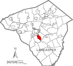
 Location in Lancaster County | |
 Willow Street Location in Pennsylvania  Willow Street Willow Street (the United States) | |
| Coordinates: 39°58′45″N 76°16′35″W | |
| Country | United States |
| State | Pennsylvania |
| County | Lancaster |
| Township | Pequea and West Lampeter |
| Area | |
| • Total | 5.4 sq mi (14 km2) |
| • Land | 5.4 sq mi (14 km2) |
| • Water | 0.0 sq mi (0 km2) |
| Elevation | 482 ft (147 m) |
| Population | |
| • Total | 7,578 |
| Time zone | UTC-5 (Eastern (EST)) |
| • Summer (DST) | UTC-4 (EDT) |
| ZIP code | 17584 |
| Area code(s) | 717 |
| GNIS feature ID | 1191509[2] |
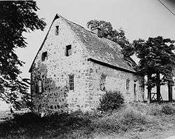
It is the location of the Hans Herr House, the oldest homestead in Lancaster County, and also the Martin Meylin Gunshop, where the long rifle was first made.
General information
- ZIP code: 17584
Geography
Willow Street is located at 39°58′41″N 76°16′28″W.[3]
According to the United States Census Bureau, the CDP has a total area of 5.4 square miles (14 km2), all of it land.
Demographics
As of the census[4] of 2000, there were 7,258 people, 3,203 households, and 2,091 families living in the CDP. The population density was 1,340.9 people per square mile (518.0/km²). There were 3,323 housing units at an average density of 613.9/sq mi (237.2/km²). The racial makeup of the CDP was 98.26% White, 0.37% African American, 0.04% Native American, 0.51% Asian, 0.36% from other races, and 0.45% from two or more races. Hispanic or Latino of any race were 1.18% of the population.
There were 3,203 households, out of which 19.2% had children under the age of 18 living with them, 58.7% were married couples living together, 4.9% had a female householder with no husband present, and 34.7% were non-families. 32.2% of all households were made up of individuals, and 25.7% had someone living alone who was 65 years of age or older. The average household size was 2.15 and the average family size was 2.69.
In the CDP, the population was spread out, with 17.1% under the age of 18, 4.6% from 18 to 24, 18.9% from 25 to 44, 17.1% from 45 to 64, and 42.4% who were 65 years of age or older. The median age was 54 years. For every 100 females, there were 80.0 males. For every 100 females age 18 and over, there were 76.4 males.
The median income for a household in the CDP was $45,103, and the median income for a family was $58,611. Males had a median income of $43,580 versus $25,523 for females. The per capita income for the CDP was $25,292. About 1.2% of families and 2.8% of the population were below the poverty line, including 2.6% of those under age 18 and 3.8% of those age 65 or over.
References
- "U.S. Census website". United States Census Bureau. Retrieved January 7, 2016.
- "Willow Street". Geographic Names Information System. United States Geological Survey.
- "US Gazetteer files: 2010, 2000, and 1990". United States Census Bureau. 2011-02-12. Retrieved 2011-04-23.
- "U.S. Census website". United States Census Bureau. Retrieved 2008-01-31.
