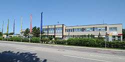
Wiener Neudorf
Wiener Neudorf (Central Bavarian: Weana Neiduaf) is an Austrian town in the eastern part of the Mödling district, south of Vösendorf and Maria Enzersdorf, west of Biedermannsdorf, and north of Guntramsdorf.
Wiener Neudorf Weana Neiduaf | |
|---|---|
 | |
 Coat of arms | |
 Wiener Neudorf Location within Austria | |
| Coordinates: 48°5′N 16°19′E | |
| Country | Austria |
| State | Lower Austria |
| District | Mödling |
| Government | |
| • Mayor | Herbert Janschka (ÖVP) |
| Area | |
| • Total | 6.06 km2 (2.34 sq mi) |
| Elevation | 205 m (673 ft) |
| Population (2018-01-01)[2] | |
| • Total | 9,405 |
| • Density | 1,600/km2 (4,000/sq mi) |
| Time zone | UTC+1 (CET) |
| • Summer (DST) | UTC+2 (CEST) |
| Postal code | 2351, 2355 |
| Area code | 02236 |
| Website | www.wr-neudorf.at |
History
First settled in 4000 B.C., the first mention of Wiener Neudorf was as Nowendorf in the mid-12th century. In 1270 a paper mentioned tolls for traveling from Sollenau and Neudorf. Circa 1500 the 'Feste Neudorf' fortification was destroyed twice by invading Turks. In 1854, Wiener Neudorf became the official name, which stemmed from the postal system development in the early 19th century (Wiener Neudorf gained the letter 'W' to differentiate the name).
Wiener Neudorf industrialisation began in the mid-19th century especially due to the available clay used by the Neudorfer Ziegelwerke of Wienerberger. The Austria Brauerei major brewery was located in Wiener Neudorf as well. By 1900 the telephone network was unified with the neighbouring municipalities and the sewage system had been extended.
- Nazi Germany
- After the 1938 Anschluss, Wiener Neudorf became part of the 24th municipality of Vienna. Circa 1940 construction of the Flugmotorenwerke Ostmark aircraft engine factory was started at Wiener Neudorf, and forced labor was provided by a subcamp of Mauthausen concentration camp. Allied attacks included the August 23, 1944 raid which bombed the South industrial area of Vienna, including the Wiener Neudorf aircraft engine factory, the Vösendorf oil refinery, and Markersdorf Airfield. An earlier bombing was on July 26, 1944. On April 6, 1945, the town fell into Russian hands.
Mödling was returned to Lower Austria in 1954.
Population
| Year | Pop. | ±% |
|---|---|---|
| 1971 | 4,072 | — |
| 1981 | 7,933 | +94.8% |
| 1991 | 8,385 | +5.7% |
| 2001 | 8,428 | +0.5% |
Politics
By seats in the municipal council. Total 33.
| Election | ÖVP ('Conservatives') | SPÖ ('Labour') | Grüne ('Green') | UFO (Local Party) | FPÖ ('Nationalistic') | |
|---|---|---|---|---|---|---|
| 2005 | 3 | 18 | 0 | 12 | 0 | |
| 2010 | 12 | 17 | 0 | 3 | 1 | |
| 2015 | 11 | 15 | 0 | 5 | 2 |
Traffic
Wiener Neudorf lies directly at the B-17 'Wiener Neudstädter Strasse', a major traffic route. Due to the proximity of the Shopping City Süd, the road experiences frequent traffic jams. Also close to the town lies the A2 'Südautobahn'.
Economy
Wiener Neudorf is home to the 'Industriezentrum NÖ Süd', a conglomerate of various industries and major economy factor in the south of Vienna.
Culture and Sights
- Altes Rathaus (lit. 'Old town hall') - now a cultural center in Wiener Neudorf.
- Maria Schnee church
- Christoph Migazzi house - another cultural center
References
- "Dauersiedlungsraum der Gemeinden Politischen Bezirke und Bundesländer - Gebietsstand 1.1.2018". Statistics Austria. Retrieved 10 March 2019.
- "Einwohnerzahl 1.1.2018 nach Gemeinden mit Status, Gebietsstand 1.1.2018". Statistics Austria. Retrieved 9 March 2019.
- 'Kurt Janetschek - Wiener Neudorf im Wandel der Zeit, 1978'