Westbury, Shropshire
Westbury is a village and parish in Shropshire, England. It includes the settlements of Caus Forest, Lake, Marche, Newtown, Stoney Stretton, Vennington, Wallop, Westbury, Whitton, Winsley and Yockleton. It lies 8 miles (13 km) west of the town of Shrewsbury, very close to the Wales-England border. It is located at 135 m altitude. It had a population of 1,352 according to the 2011 census.[2] In 2005, Westbury parish expanded with the annexation of half of the former Wollaston parish.
| Westbury | |
|---|---|
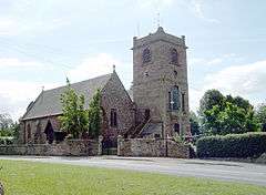 St Mary's church in Westbury. | |
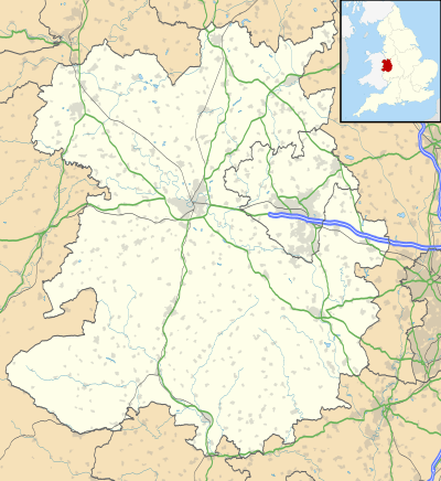 Westbury Location within Shropshire | |
| Area | 15 sq mi (39 km2) [1] |
| Population | 1,352 [2] |
| • Density | 90/sq mi (35/km2) |
| OS grid reference | SJ355094 |
| Civil parish |
|
| Unitary authority | |
| Ceremonial county | |
| Region | |
| Country | England |
| Sovereign state | United Kingdom |
| Post town | SHREWSBURY |
| Postcode district | SY5 |
| Dialling code | 01743 |
| Police | West Mercia |
| Fire | Shropshire |
| Ambulance | West Midlands |
| UK Parliament | |
It is situated on the B4386 road which travels from Shrewsbury to Montgomery. Amenities include a Royal Mail Post Office, a Marstons Pub called 'The Lion', a medical practice surgery, and a cemetery on Hinwood Road. The primary school (St Mary's CE Aided) closed in 2017, merging in a federation with Worthen and Hope into the Long Mountain School at Worthen.
History
During the Roman settlement of Britain it was an outpost of Wroxeter. In about 1848, a piece of lead was found with markings of the name of the Roman Emperor Aurelian.[3] About one mile (1.6 km) from Westbury lie the scant ruins of Caus Castle, which was originally used as a border stronghold.[3] The castle was built in the late 11th century.
In 1870–72, Westbury was described by John Marius Wilson's Imperial Gazetteer of England and Wales like this:
- "WESTBURY, a township and a parish in Atcham district, Salop. The township lies on the Shrewsbury and Welshpool railway, 11½ miles W by S of Shrewsbury; contains a village of its own name; and has a post-office under Shrewsbury, and a r[ailway]. station. Real property, £6,174; of which £200 are in mines. Pop[ulation]. in 1851, 1,497; in 1861, 1,655. Houses, 298. The property is not much divided. The parish includes Minsterley chapelry, and forms a sub-district. Acres, 11,274. Rated property in 1869, £16,158. Pop., 2,545. Houses, 476. The living is a rectory in the diocese of Hereford. Value, £766. Patron, R. Cholmondeley, Esq. The church is good. The p[erpetual]. curacy of Minsterley is a separate benefice. There are dissenting chapels, an endowed school with £30 a year, and charities £44."[4]
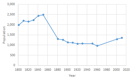

In 1831 the dominating occupation was working in agriculture and farming.[5] There were no manufacturing jobs in 1831.[5] In 2001 there were 80, which decreased to 52 in 2011.[6][7] Several coal and lead mines were being worked near Shrewsbury and Westbury at the former time. Many collieries were closed by 1921, with the last closing in 1941.[8]

Railways
Previously served by Westbury station on the Cambrian Line.
Notable people
- Sir Thomas Higgons (c1624-1691), politician and diplomat, was son of a Rector of Westbury.
- William Cureton (1808-1864), Orientalist, was born at Westbury.
- John Edmund Severne (1826-1899), Conservative politician, lived at Wallop Hall in Westbury parish, buried in Westbury Churchyard.
- John Doogan (1853-1940), Victoria Cross recipient, was living at Cause Mountain in Westbury parish in 1911.[9]
- Sir Smith Child, 2nd Baronet (1880-1958), Conservative politician and former army officer, lived at Whitton Hall[10] in the parish and is buried in Westbury Churchyard.
References
- "Westbury (Parish): Population Density, 2011". Neighbourhood Statistics. Office for National Statistics. Retrieved 28 April 2014.
- "Westbury (Parish): Key Figures for 2011 Census: Key Statistics". Neighbourhood Statistics. Office for National Statistics. Retrieved 28 April 2014.
- Hinson, Colin. "The National Gazetteer of Great Britain and Ireland". GENUKI. Retrieved 28 April 2014.
- Wilson, John Marius (1870–72). Imperial Gazetteer of England and Wales. Westbury: A. Fullarton & Co. Retrieved 28 April 2014.
- GB Historical GIS / University of Portsmouth, A Vision of Britain through Time. "Westbury CP/AP through time. Males aged 20 & over, in 9 occupational categories in 1831". Industry Statistics. Retrieved 28 April 2014.
- "Westbury (Parish): Industry of Employment 2001". Neighbourhood Statistics. Office for National Statistics. Retrieved 28 April 2014.
- "Westbury (Parish): Industry, 2011". Neighbourhood Statistics. Office for National Statistics. Retrieved 28 April 2014.
- Shropshire Mines. "Shrewsbury Coalfield". Retrieved 28 April 2014.
- 1911 Census of England and Wales, form at National Archives AncestryLibrary.com.
- Kelly's Handbook to the Titled, Landed and Official Classes, 1948. Kelly's. p. 458.Earliest mention of Whitton Hall as home.
External links
| Wikimedia Commons has media related to Westbury, Shropshire. |
| Unitary authorities | |
|---|---|
| Major settlements | |
| Rivers | |
| Canals | |
| Topics | |