Wellington Parish, New Brunswick
Wellington is a civil parish[lower-alpha 1] in Kent County, New Brunswick, Canada. For governance purposes it is divided between the town of Bouctouche, Buctouche 16 Indian reserve, and the local service districts of Sainte-Anne-de-Kent and the parish of Wellington, which in turn includes the special service areas of Bouctouche Cove, Desroches,[lower-alpha 2] Dixon Point-Route 134,[lower-alpha 3] and Saint-Grégoire.[lower-alpha 4]
Wellington | |
|---|---|
 Saint-Édouard-de-Kent | |
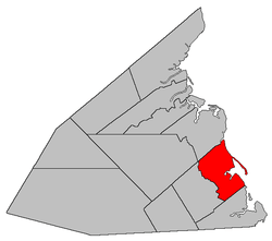 Location within Kent County, New Brunswick. | |
| Coordinates: 46.525°N 64.745°W | |
| Country | |
| Province | |
| County | Kent County |
| Established | 1814 |
| Area | |
| • Land | 184.32 km2 (71.17 sq mi) |
| Population (2016)[1] | |
| • Total | 3,079 |
| • Density | 16.7/km2 (43/sq mi) |
| • Change 2011-2016 | |
| • Dwellings | 1,716 |
| Time zone | UTC-4 (AST) |
| • Summer (DST) | UTC-3 (ADT) |
Its population in the 2016 Census was 3,079.[1]
Delineation
Wellington Parish is defined in the Territorial Division Act[3] as being bounded:
- South by Dundas Parish; north by Chockpish River and a line running south sixty-eight degrees west from the forks thereof; east by the Gulf of Saint Lawrence; and west by a line commencing where the southerly prolongation of the line between lots U and V, on the Little Buctouche River, strikes the northern boundary of Dundas Parish; thence along the prolongation of the said line north forty-three degrees west to the Little Buctouche River; thence down stream to the westerly line of lot number 7, granted to Joshua White; thence along the said westerly line of said lot to the northwest corner thereof; thence in a direct line to the southeast corner of lot number 13, granted to Michael Basterache, on the south side of the Buctouche River; thence along the eastern line of that lot northerly to the Buctouche River; thence to the mouth of Mill Creek; thence following the course of the said creek up stream to the eastern line of the grant to John W. Holderness, on said creek; thence northerly along that line to the rear line of said grant; thence westerly along said line to the western line of lots granted to Angus Cameron; thence northerly along that line and its prolongation to Mill Creek; thence following the various courses thereof up stream to the eastern line of lot number 101, granted to John McEachran; thence northerly along that line and its northern prolongation to the northern line of lot number 95, granted to John McNairn; thence westerly along the said last mentioned line and its western prolongation to meet the eastern line of lot number 138, granted to George Holder; thence along said eastern line and its prolongation in a northerly direction to the northern line of lot number 110 in Block O; thence along that line in an easterly direction to meet the southern prolongation of the eastern line of lot number 52, granted to John Cochrane; thence along said prolongation and eastern line of said last mentioned grant to the northern line of the parish, including the islands in front.
Communities
|
|
|
Demographics
Population
|
LanguageMother tongue (2016)[1]
|
gollark: The UK doesn't really seem to have spoofing or nuisance calls anywhere near as much of the US, and I'm not sure why, given that it's technically possible in both.
gollark: The phone network really needs fixing to *not* allow spoofing.
gollark: <@617750798960558091> I briefly mistook that knife for a fish.
gollark: Apparently some company called "Springer" is making a lot of textbooks free right now if anyone is interested: https://www.reddit.com/r/learnmachinelearning/comments/fvncjm/springer_is_giving_free_access_to_409_of_its/
gollark: It is very impressive for a hand-drawn map.
See also
Notes
- Civil parishes served a variety of government functions until 1966, when the new Municipalities Act stripped them of their responsibilities; they continue to provide convenient boundaries for government uses, especially electoral districts and local service districts. Statistics Canada uses civil parishes as census subdivisions for all parts of the province that are not within municipalities and similar entities.
- Taxing Authority Wellington - Desroches[2]
- Taxing Authority Wellington - Dixon Point-Route 134[2]
- Although not explicitly mention in Regulation 84-168, Saint-Grégoire's boundaries extend into Dundas Parish
References
- "Census Profile, 2016 Census Wellington, Parish [Census subdivision], New Brunswick". Statistics Canada. Retrieved September 14, 2019.
- "2019 Local Government Statistics for New Brunswick" (PDF). Department of Environment and Local Government. p. 61. Retrieved 9 July 2020.
- "Territorial Division Act (R.S.N.B. 1973, c. T-3)". Government of New Brunswick website. Retrieved 30 August 2016.
- Statistics Canada: 1996, 2001, 2006 census
- 2011 Statistics Canada Census Profile: Wellington Parish, New Brunswick
Places adjacent to Wellington Parish, New Brunswick | ||||||||||
|---|---|---|---|---|---|---|---|---|---|---|
| ||||||||||
| Subdivisions |
|
|---|---|
| Cities | |
| Counties | |
| |
This article is issued from Wikipedia. The text is licensed under Creative Commons - Attribution - Sharealike. Additional terms may apply for the media files.