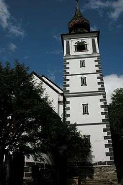
Weißpriach
Weißpriach is a municipality in the district of Tamsweg in the state of Salzburg in Austria. It is located in a valley of the Niedere Tauern mountain range.
Weißpriach | |
|---|---|
 Church of Saint Rupert | |
 Coat of arms | |
 Weißpriach Location within Austria | |
| Coordinates: 47°10′00″N 13°42′00″E | |
| Country | Austria |
| State | Salzburg |
| District | Tamsweg |
| Government | |
| • Mayor | Peter Bogensperger (ÖVP) |
| Area | |
| • Total | 80.20 km2 (30.97 sq mi) |
| Elevation | 1,099 m (3,606 ft) |
| Population (2018-01-01)[2] | |
| • Total | 306 |
| • Density | 3.8/km2 (9.9/sq mi) |
| Time zone | UTC+1 (CET) |
| • Summer (DST) | UTC+2 (CEST) |
| Postal code | 5571 |
| Area code | 06473 |
| Vehicle registration | TA |
| Website | www.weisspriach.at |
History
Weißpriach is known for the Romanesque church of Saint Rupert with its Byzantine frescoes. The foundations probably date from the Christianization under the rule of Duke Tassilo III of Bavaria in the 8th century and may have replaced a Roman temple.
Politics
Seats in the municipal assembly (Gemeinderat) as of 2009 elections:
- 5 Austrian People's Party (ÖVP)
- 2 Social Democratic Party of Austria (SPÖ)
- 2 Freedom Party of Austria (FPÖ)
gollark: https://abishekmuthian.com/wp-content/uploads/2019/06/enable-USB-boot.png
gollark: Well, you could always sit in an extremely cold room, such that you expand MUCH energy maintaining normal temperatures.
gollark: I think I read something saying that that wasn't very accurate, but I forgot it, so oh well.
gollark: Then convert them to machines first, whatever.
gollark: A GOOD legal system would force them into indentured servitude to you.
References
- "Dauersiedlungsraum der Gemeinden Politischen Bezirke und Bundesländer - Gebietsstand 1.1.2018". Statistics Austria. Retrieved 10 March 2019.
- "Einwohnerzahl 1.1.2018 nach Gemeinden mit Status, Gebietsstand 1.1.2018". Statistics Austria. Retrieved 9 March 2019.
This article is issued from Wikipedia. The text is licensed under Creative Commons - Attribution - Sharealike. Additional terms may apply for the media files.