Wawer
Wawer [ˈvavɛr] is one of the districts of Warsaw, located in the south-eastern part of the city. The Vistula river runs along its western border. Wawer became a district of Warsaw on 27 October 2002 (previously it was a part of Praga Południe district, and a municipality earlier).
Wawer | |
|---|---|
 Coat of arms | |
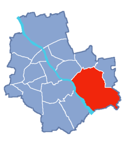 Location of Wawer within Warsaw | |
| Coordinates: 52°12′50″N 21°9′29″E | |
| Country | |
| Voivodeship | Masovian |
| County/City | Warsaw |
| Government | |
| • Mayor | Norbert Szczepański |
| Area | |
| • Total | 79.71 km2 (30.78 sq mi) |
| Population (2003) | |
| • Total | 62,656 |
| • Density | 790/km2 (2,000/sq mi) |
| Time zone | UTC+1 (CET) |
| • Summer (DST) | UTC+2 (CEST) |
| Area code(s) | +48 22 |
| Website | wawer.warszawa.pl |
Wawer borders Praga Południe and Rembertów from the north, Wesoła from the east and Wilanów with Mokotów from the west (across the Vistula).
Boroughs
- Aleksandrów
- Anin
- Falenica
- Las
- Marysin Wawerski
- Miedzeszyn
- Międzylesie
- Nadwiśle
- Radość
- Sadul
- Wawer
- Zerzeń.
History
In 1939, the Wawer massacre occurred here.
gollark: So many xenowyrms in the hatchery...
gollark: y e e p
gollark: This should help people asking "can I get X for Y?"
gollark: Another idea: running surveys to get people's views on the trading value of things.
gollark: I'm used to about half of the names I want being taken, soo...
References
| Wikimedia Commons has media related to Wawer. |
- Urząd Dzielnicy Wawer
- Lokalny Serwis Informacyjny - Wawer
- Serwis "Moja dzielnica" Wawer
- Świdermajer - The characteristic architecture in the area
| Authority control |
|---|
This article is issued from Wikipedia. The text is licensed under Creative Commons - Attribution - Sharealike. Additional terms may apply for the media files.