Waratah, New South Wales
Waratah /ˌwɒrəˈtɑː/ is a north-western residential suburb of Newcastle, New South Wales, Australia 6 kilometres (4 mi) from Newcastle's central business district and bounded on the north by the Main North railway line.[7] Waratah station was opened in 1858 and is served by NSW TrainLink's Hunter line.[8]
| Waratah Newcastle, New South Wales | |||||||||||||||
|---|---|---|---|---|---|---|---|---|---|---|---|---|---|---|---|
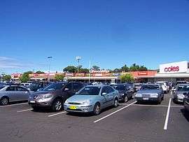 Waratah Village Shopping Centre in March 2011 | |||||||||||||||
Waratah | |||||||||||||||
| Coordinates | 32°54′19″S 151°43′30″E | ||||||||||||||
| Population | 4,491 (2016 census)[1] | ||||||||||||||
| • Density | 2,360/km2 (6,120/sq mi) [Note 1] | ||||||||||||||
| Established | 1871 | ||||||||||||||
| Postcode(s) | 2298 | ||||||||||||||
| Area | 1.9 km2 (0.7 sq mi)[Note 2] | ||||||||||||||
| Time zone | AEST (UTC+10) | ||||||||||||||
| • Summer (DST) | AEDT (UTC+11) | ||||||||||||||
| Location | 6 km (4 mi) WNW of Newcastle | ||||||||||||||
| LGA(s) | City of Newcastle[2] | ||||||||||||||
| Region | Hunter[2] | ||||||||||||||
| County | Northumberland[3] | ||||||||||||||
| Parish | Newcastle[3] | ||||||||||||||
| State electorate(s) | |||||||||||||||
| Federal Division(s) | Newcastle[6] | ||||||||||||||
| |||||||||||||||
History
Waratah was once a major municipality in its own right, with an elected council and mayor, incorporated in 1871. Two notable mayors, both elected to the office three times each were John Scholey and auctioneer N.B.Creer, both of whom resided at North Waratah (now Mayfield, New South Wales). Scholey was instrumental in the establishment of the Waratah Bowling Club of which he was also patron.
Originally Waratah had as its industrial base a large colliery bearing its name.[9]
The suburb contains a major acute hospital, the Calvary Mater (formerly the "Mater Misericordiae"), owned by the Roman Catholic Sisters of Mercy, who, until recently occupied all the most senior nursing positions. Nearby is an established major 150+ -bed independent Home of the Elderly, Maroba.
Schools
- Callaghan College Waratah Technology Campus (Years 7–10)[10] (formerly Waratah High School, and before that Newcastle Boys' High School)
- Waratah Public School (State sector)[11]
- St. Philip's Christian College[12]
- Corpus Christi (Roman Catholic Primary School)[13]
Local landmarks
- Calvary Mater Hospital[14]
- Maroba Nursing Home[15]
- Corpus Christi Catholic Church
- Waratah Oval and Park
- Mens Shed
- Hunter Prostate Cancer Alliance
- Waratah Police Station
- Newcastle Eye Hospital
- Tinonee Gardens aged care facility
- Braye Park
- Waratah has one shopping centre, Waratah Village, which contains a Coles and a 24-hour Kmart store, a newsagent/post office, Newcastle Permanent Building Society branch, Greater Building Society branch, and other specialty stores. It is renowned for an exuberant Christmas lighting display.
- Station Street approximately 200 m (656 ft) away has two hotels (The Royal (Purple) and The Town Hall (Orange)), a general practice surgery, and some smaller shops. Various shops and the old Waratahs Rugby Club have been converted into 2 childcare facilities.
Notes
- This is the average density of the actual township where most of the population lives, not the average for the whole area which is considerably lower at 328/km2 (850/sq mi). This lower figure does not accurately represent the population density in either the town itself or the surrounding rural area where the population density is actually closer to 13/km2 (34/sq mi).
- Area calculation is based on 1:100000 map 9232 NEWCASTLE.
References
- Australian Bureau of Statistics (27 June 2017). "Waratah (NSW) (State Suburb)". 2016 Census QuickStats. Retrieved 9 February 2018.

- "Suburb Search – Local Council Boundaries – Hunter (HT) – Newcastle City Council". New South Wales Division of Local Government. Retrieved 11 November 2012.
- "Waratah". Geographical Names Register (GNR) of NSW. Geographical Names Board of New South Wales. Retrieved 11 November 2012.
- "Newcastle". New South Wales Electoral Commission. Retrieved 23 November 2019.
- "Wallsend". New South Wales Electoral Commission. Retrieved 23 November 2019.
- "Newcastle". Australian Electoral Commission. 26 July 2012. Retrieved 11 November 2012.
- "Waratah". Land and Property Management Authority - Spatial Information eXchange. New South Wales Land and Property Information. Retrieved 11 November 2012.
- "Main North Line". www.nswrail.net. Retrieved 22 November 2006.
- Australian Railway Historical Society Bulletin, November 1963 pp. 173–178
- "Waratah Technology Campus". Waratah-h.schools.nsw.edu.au. Retrieved 23 October 2011.
- "home". Waratah-p.schools.nsw.edu.au. Retrieved 23 October 2011.
- "St. Philip's Christian College". Spcc.nsw.edu.au. Retrieved 23 October 2011.
- "Home". Wrtah.mn.catholic.edu.au. Retrieved 23 October 2011.
- Archived 11 April 2005 at the Wayback Machine
- "Maroba". Users.hunterlink.net.au. Retrieved 23 October 2011.
External links
| Wikimedia Commons has media related to Waratah, New South Wales. |