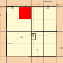
Walnut Township, Adair County, Iowa
Walnut Township is one of seventeen townships in Adair County, Iowa, USA. At the 2010 census, its population was 176.[3]
Walnut Township, Adair County | |
|---|---|
 | |
| Coordinates: 41°27′39″N 094°31′48″W | |
| Country | |
| State | |
| County | Adair |
| Area | |
| • Total | 35.65 sq mi (92.34 km2) |
| • Land | 35.55 sq mi (92.07 km2) |
| • Water | 0.1 sq mi (0.27 km2) |
| Elevation | 1,286 ft (392 m) |
| Population (2010) | |
| • Total | 176 |
| • Density | 5.0/sq mi (1.9/km2) |
| Time zone | UTC-6 (CST) |
| • Summer (DST) | UTC-5 (CDT) |
| FIPS code | 19-94389[2] |
| GNIS feature ID | 0468881 |
Geography
Walnut Township covers an area of 35.65 square miles (92.3 km2) and contains no incorporated settlements. According to the USGS, it contains four cemeteries: Abandoned Timber, Canby, Oakwood and Saint Josephs.
gollark: And most of the pixel density is in the middle.
gollark: However, not all of it is used on a monitor at a time.
gollark: I am aware.
gollark: <@151391317740486657> Idea: join SCCraft™ and visit the Apiaristics Division™.
gollark: I suppose they are good if you have a *really big* display to replace several lower-resolution monitors.
References
- "US Board on Geographic Names". United States Geological Survey. 2007-10-25. Retrieved 2008-01-31.
- "U.S. Census website". United States Census Bureau. Retrieved 2008-01-31.
- "IA - Walnut township". United States Census Bureau. Archived from the original on April 9, 2013. Retrieved March 17, 2013.
This article is issued from Wikipedia. The text is licensed under Creative Commons - Attribution - Sharealike. Additional terms may apply for the media files.