Virginia State Route 243
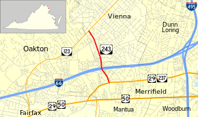
State Route 243 (SR 243) is a primary state highway in the U.S. state of Virginia. Known as Nutley Street, the state highway runs 1.70 miles (2.74 km) from U.S. Route 29 (US 29) and State Route 237 (SR 237) on the border between Oakton and Merrifield north to State Route 123 (SR 123) in Vienna. SR 243 connects Vienna and Fairfax with Interstate 66 (I-66) and the Vienna station of the Washington Metro.
| ||||
|---|---|---|---|---|
| Nutley Street | ||||
 | ||||
| Route information | ||||
| Maintained by VDOT | ||||
| Length | 1.70 mi[1] (2.74 km) | |||
| Existed | 1960–present | |||
| Major junctions | ||||
| South end | ||||
| North end | ||||
| Location | ||||
| Counties | Fairfax | |||
| Highway system | ||||
| ||||
Route description
_at_Virginia_State_Route_243_(Nutley_Street)_in_Vienna%2C_Fairfax_County%2C_Virginia.jpg)
_at_Virginia_State_Route_123_(Maple_Avenue)_in_Vienna%2C_Fairfax_County%2C_Virginia.jpg)
SR 243 begins at an intersection with US 29 and SR 237 (Lee Highway) between the independent city of Fairfax and the community of Merrifield. Nutley Street continues south 0.51 miles (0.82 km) as a two-lane road designated SR 10272 to US 50 (Arlington Boulevard). SR 243 heads north as a six-lane divided highway through a cloverleaf interchange with I-66 just east of the Vienna station of the Washington Metro, which is the western terminus of the Orange Line that runs in the median of the Interstate from Vienna east to Arlington. Access to the station is provided by the first intersection on either side of the I-66 interchange. SR 243 continues into the town of Vienna as a four-lane divided boulevard that passes between residential neighborhoods before reaching its northern terminus at SR 123 (Maple Avenue) southwest of downtown Vienna. Nutley Street continues north as a two-lane residential street for four blocks to Malcolm Road.[1][2]
Major intersections
The entire route is in Fairfax County.
| Location | mi[1] | km | Destinations | Notes | |
|---|---|---|---|---|---|
| Oakton–Merrifield line | 0.00 | 0.00 | Continues south without designation | ||
| 0.40 | 0.64 | Exit 62 on I-66 | |||
| Vienna | 1.70 | 2.74 | Continues north without designation | ||
| 1.000 mi = 1.609 km; 1.000 km = 0.621 mi | |||||
References
- "2010 Traffic Data". Virginia Department of Transportation. 2010. Retrieved 2011-12-13.
- Google (2011-12-13). "Virginia State Route 243" (Map). Google Maps. Google. Retrieved 2011-12-13.
External links
| Wikimedia Commons has media related to Virginia State Route 243. |
