Vikravandi
Vikravandi is a town in Viluppuram district in the Indian state of Tamil Nadu.
Vikravandi | |
|---|---|
town | |
 Vikravandi Location in Tamil Nadu, India | |
| Coordinates: 12.03°N 79.55°E | |
| Country | |
| State | Tamil Nadu |
| District | Viluppuram |
| Government | |
| • Type | town |
| Area | |
| • Total | 12.22 km2 (4.72 sq mi) |
| Elevation | 44 m (144 ft) |
| Population (2001) | |
| • Total | 10,449 |
| • Density | 860/km2 (2,200/sq mi) |
| Languages | |
| • Official | Tamil |
| Time zone | UTC+5:30 (IST) |
| Vehicle registration | TN-32 |
Geography
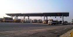
Toll Plaza at Vikravandi
Vikravandi is located at 12.03°N 79.55°E.[1] It has an average elevation of 44 metres (144 feet). It lies along the Chennai - Trichy National Highway 45.[2]
Demographics
As of 2001 India census,[3] Vikravandi had a population of 10,141. Males constitute 52% of the population and females 48%. Vikravandi has an average literacy rate of 74%, higher than the national average of 59.5%: male literacy is 81%, and female literacy is 66%. In Vikravandi, 10% of the population is under 6 years of age.
gollark: Parse THAT!
gollark: Nobody is requiring a response here, but we can totally make them.
gollark: I agree with "andrew" the "discorder".
gollark: No u.
gollark: Palaiologos is clearly an especially 1337 h4xx0r if they threaten to "doxx" people.
References
- Falling Rain Genomics, Inc - Vikravandi
- Ramakrishnan, Deepa (3 January 2012). "New collection system takes a toll of TNSTC special buses". Chennai. The Hindu. Retrieved 30 October 2012.
- "Census of India 2001: Data from the 2001 Census, including cities, villages and towns (Provisional)". Census Commission of India. Archived from the original on 16 June 2004. Retrieved 1 November 2008.
This article is issued from Wikipedia. The text is licensed under Creative Commons - Attribution - Sharealike. Additional terms may apply for the media files.