Vieira do Minho
Vieira do Minho (Portuguese pronunciation: [viˈɐjɾɐ ðu ˈmiɲu] (![]()
Vieira do Minho | |
|---|---|
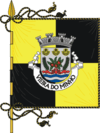 Flag .png) Coat of arms | |
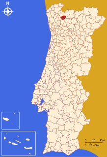 | |
| Coordinates: 41°38′N 8°08′W | |
| Country | |
| Region | Norte |
| Intermunic. comm. | Ave |
| District | Braga |
| Parishes | 16 |
| Government | |
| • President | António Cardoso (PSD-CDS) |
| Area | |
| • Total | 216.44 km2 (83.57 sq mi) |
| Population (2011) | |
| • Total | 12,997 |
| • Density | 60/km2 (160/sq mi) |
| Time zone | UTC±00:00 (WET) |
| • Summer (DST) | UTC+01:00 (WEST) |
| Website | www |
The present mayor is António Cardoso, elected by a coalition between PSD and the CDS-PP People's Party (Portugal).
Parishes
Administratively, the municipality is divided into 16 civil parishes (freguesias):[3]
- Anissó e Soutelo
- Anjos e Vilar do Chão
- Caniçada e Soengas
- Cantelães
- Eira Vedra
- Guilhofrei
- Louredo
- Mosteiro
- Parada do Bouro
- Pinheiro
- Rossas
- Ruivães e Campos
- Salamonde
- Tabuaças
- Ventosa e Cova
- Vieira do Minho
General information
Vieira do Minho is essentially a rural municipality. Along with the town of Vieira do Minho, the seat of the municipality, the other major location in the municipality is the town of Rossas with 2,071 inhabitants.
gollark: And?
gollark: Besides, every recent computer is designed partly by computer.
gollark: My laptop can happily do a few hundred billion floating point operations a second. You can manage about 0.01, optimistically.
gollark: Nope.
gollark: Like how computers can do some things orders of magnitude better than humans and some worse.
References
- Instituto Nacional de Estatística
- Áreas das freguesias, concelhos, distritos e país
- Diário da República. "Law nr. 11-A/2013, pages 552 128-129" (pdf) (in Portuguese). Retrieved 4 August 2014.
External links
| Municipalities | |
|---|---|
| Museums |
|
| |
This article is issued from Wikipedia. The text is licensed under Creative Commons - Attribution - Sharealike. Additional terms may apply for the media files.