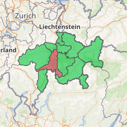
Viamala Region
Viamala Region is one of the eleven administrative districts in the canton of Graubünden in Switzerland. It had an area of 627.58 square kilometers (242.31 sq mi) and a population of 13,597 (as of 31 December 2018).[1]. It was created on 1 January 2017 as part of a reorganization of the Canton.[2]
| Municipalities in the Viamala Region | ||||
|---|---|---|---|---|
| Municipality | Population (31 December 2018)[1] |
Area (km²)[3] | ||
| Fürstenau | 353 | 1.32 | ||
| Rothenbrunnen | 299 | 3.11 | ||
| Scharans | 789 | 14.29 | ||
| Sils im Domleschg | 943 | 9.28 | ||
| Cazis | 2,228 | 31.18 | ||
| Flerden | 248 | 6.09 | ||
| Masein | 488 | 4.2 | ||
| Thusis | 9,348 | 6.81 | ||
| Tschappina | 130 | 24.67 | ||
| Urmein | 154 | 4.33 | ||
| Domleschg | 2,067 | 45.94 | ||
| Avers | 168 | 93.12 | ||
| Rheinwald | 635 | 136.82 | ||
| Sufers | 144 | 34.62 | ||
| Andeer | 908 | 46.3 | ||
| Casti-Wergenstein | 56 | 25.62 | ||
| Donat | 202 | 4.67 | ||
| Lohn (GR) | 46 | 8.17 | ||
| Mathon | 51 | 15.13 | ||
| Rongellen | 53 | 2.02 | ||
| Zillis-Reischen | 401 | 24.47 | ||
| Ferrera | 75 | 75.46 | ||
Viamala Region | |
|---|---|
District | |

| |
| Country | |
| Canton | |
| Area | |
| • Total | 627.58 km2 (242.31 sq mi) |
| Population (2018) | |
| • Total | 13,597 |
| • Density | 22/km2 (56/sq mi) |
| Time zone | UTC+1 (CET) |
| • Summer (DST) | UTC+2 (CEST) |
| Municipalities | 22 |
Mergers
- On 1 January 2018 the former municipality of Mutten merged into the municipality of Thusis.
- On 1 January 2019 the former municipalities of Hinterrhein, Nufenen and Splügen merged into the new municipality of Rheinwald.
gollark: "it's just on the LAN, who needs security"
gollark: This is why IoT ends up so awful.
gollark: Plus, well, other LAN devices can be eevil too.
gollark: "Private project" doesn't mean "ignore all security issues".
gollark: Also, please don't make it just allow remote read/write of files, because oh potatOS the security issues.
References
- Swiss Federal Statistical Office - STAT-TAB, online database – Ständige und nichtständige Wohnbevölkerung nach institutionellen Gliederungen, Geburtsort und Staatsangehörigkeit (in German) accessed 23 September 2019
- Swiss Federal Statistical Office - Amtliches Gemeindeverzeichnis der Schweiz - Mutationsmeldungen 2016 accessed 16 February 2017
- Arealstatistik Standard - Gemeindedaten nach 4 Hauptbereichen
This article is issued from Wikipedia. The text is licensed under Creative Commons - Attribution - Sharealike. Additional terms may apply for the media files.