Moesa Region
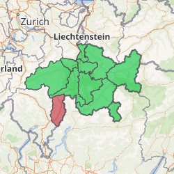
The Moesa Region is one of the eleven administrative districts in the canton of Graubünden in Switzerland. It had an area of 473.74 square kilometers (182.91 sq mi) and a population of 8,566 (as of 31 December 2018).[1]. It was created on 1 January 2017 as part of a reorganization of the Canton.[2]
| Municipalities in the Moesa Region | ||||
|---|---|---|---|---|
| Municipality | Population (31 December 2018)[1] |
Area (km²)[3] | ||
| Buseno | 87 | 11.15 | ||
| Castaneda | 275 | 3.96 | ||
| Rossa | 148 | 58.89 | ||
| Santa Maria in Calanca | 109 | 9.31 | ||
| Lostallo | 792 | 50.86 | ||
| Mesocco | 1,347 | 164.77 | ||
| Soazza | 319 | 46.42 | ||
| Cama | 560 | 15 | ||
| Grono | 1,378 | 37.12 | ||
| Roveredo (GR) | 2,520 | 38.79 | ||
| San Vittore | 832 | 22.06 | ||
| Calanca | 199 | 37.72 | ||
Moesa Region | |
|---|---|
District | |
| |
| Country | |
| Canton | |
| Area | |
| • Total | 473.74 km2 (182.91 sq mi) |
| Population (2018) | |
| • Total | 8,566 |
| • Density | 18/km2 (47/sq mi) |
| Time zone | UTC+1 (CET) |
| • Summer (DST) | UTC+2 (CEST) |
| Municipalities | 12 |
References
- Swiss Federal Statistical Office - STAT-TAB, online database – Ständige und nichtständige Wohnbevölkerung nach institutionellen Gliederungen, Geburtsort und Staatsangehörigkeit (in German) accessed 23 September 2019
- Swiss Federal Statistical Office - Amtliches Gemeindeverzeichnis der Schweiz - Mutationsmeldungen 2016 accessed 16 February 2017
- Arealstatistik Standard - Gemeindedaten nach 4 Hauptbereichen
This article is issued from Wikipedia. The text is licensed under Creative Commons - Attribution - Sharealike. Additional terms may apply for the media files.