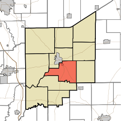
Vernon Township, Jennings County, Indiana
Vernon Township is one of eleven townships in Jennings County, Indiana, United States. As of the 2010 census, its population was 2,809 and it contained 1,118 housing units.[1]
Vernon Township | |
|---|---|
 Location in Jennings County | |
| Coordinates: 38°57′17″N 85°35′55″W | |
| Country | United States |
| State | Indiana |
| County | Jennings |
| Government | |
| • Type | Indiana township |
| Area | |
| • Total | 34.08 sq mi (88.3 km2) |
| • Land | 33.98 sq mi (88.0 km2) |
| • Water | 0.1 sq mi (0.3 km2) 0.29% |
| Elevation | 748 ft (228 m) |
| Population (2010) | |
| • Total | 2,809 |
| • Density | 82.7/sq mi (31.9/km2) |
| GNIS feature ID | 0453957 |
Geography
According to the 2010 census, the township has a total area of 34.08 square miles (88.3 km2), of which 33.98 square miles (88.0 km2) (or 99.71%) is land and 0.1 square miles (0.26 km2) (or 0.29%) is water.[1] The streams of Crooked Creek, Duck Branch, Goose Run and Huckleberry Branch run through this township.
Cities and towns
- North Vernon (southeast edge)
- Vernon (the county seat)
Unincorporated towns
Adjacent townships
- Center Township (north)
- Campbell Township (northeast)
- Bigger Township (east)
- Lovett Township (southwest)
- Spencer Township (west)
Cemeteries
The township contains six cemeteries: Baldwin, Coryell, Ebenezer, Stewart, Sullivan and Vernon.
Major highways
gollark: If you are to actually make bold claims about theoretical physics instead of just paraphrasing random quantum things it would be beneficial to learn the relevant maths so you can understand the models.
gollark: I'm glad you are adding topic labels to this. This is very useful and I'd never have known this without you mentioning it.
gollark: Fascinating.
gollark: As far as I know this is only true of some things, and in general things just have mass because they have energy and ??? things occur with this.
gollark: If you are saying "the only reason anything has mass is the Highs boson" then according to my very approximate knowledge this is not true.
References
- "Population, Housing Units, Area, and Density: 2010 - County -- County Subdivision and Place -- 2010 Census Summary File 1". United States Census. Archived from the original on 2020-02-12. Retrieved 2013-05-10.
This article is issued from Wikipedia. The text is licensed under Creative Commons - Attribution - Sharealike. Additional terms may apply for the media files.