Vermilion, Illinois
Vermilion is a village in Stratton and Elbridge Township townships, Edgar County, Illinois, United States. The population was 225 at the 2010 census.
Vermilion | |
|---|---|
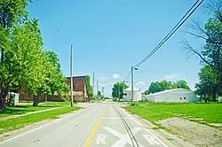 Church Street | |
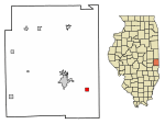 Location of Vermilion in Edgar County, Illinois. | |
 Vermilion Vermilion's location in Edgar County | |
| Coordinates: 39°34′52″N 87°35′20″W | |
| Country | |
| State | |
| County | Edgar |
| Township | Elbridge, Stratton |
| Area | |
| • Total | 0.55 sq mi (1.41 km2) |
| • Land | 0.55 sq mi (1.41 km2) |
| • Water | 0.00 sq mi (0.00 km2) |
| Elevation | 673 ft (205 m) |
| Population (2010) | |
| • Total | 225 |
| • Estimate (2019)[2] | 202 |
| • Density | 369.96/sq mi (142.79/km2) |
| ZIP code | 61955 |
| Area code(s) | 217 |
| FIPS code | 17-77551 |
History
Vermilion was established in the mid-1850s and named for its first postmaster. The spelling was originally "Vermillion" (with two L's), but was changed to the current spelling (with one L) in 1949. Vermilion incorporated in 1873.[3]
Geography
Vermilion is located at 39°34′49″N 87°35′19″W (39.580343, -87.588492),[4] about three miles west of the border with Indiana, and just south of U.S. Route 150. A CSX railroad passes from northwest to southeast through the middle of the town on its route between Paris and Terre Haute, Indiana.
According to the 2010 census, Vermilion has a total area of 0.76 square miles (1.97 km2), all land.[5]
Demographics
| Historical population | |||
|---|---|---|---|
| Census | Pop. | %± | |
| 1880 | 387 | — | |
| 1890 | 325 | −16.0% | |
| 1900 | 305 | −6.2% | |
| 1910 | 287 | −5.9% | |
| 1920 | 318 | 10.8% | |
| 1930 | 279 | −12.3% | |
| 1940 | 312 | 11.8% | |
| 1950 | 316 | 1.3% | |
| 1960 | 317 | 0.3% | |
| 1970 | 333 | 5.0% | |
| 1980 | 299 | −10.2% | |
| 1990 | 283 | −5.4% | |
| 2000 | 239 | −15.5% | |
| 2010 | 225 | −5.9% | |
| Est. 2019 | 202 | [2] | −10.2% |
| U.S. Decennial Census[6] | |||
As of the census[7] of 2000, there were 239 people, 93 households, and 75 families residing in the village. The population density was 313.6 people per square mile (121.4/km2). There were 105 housing units at an average density of 137.8 per square mile (53.3/km2). The racial makeup of the village was 99.16% White, and 0.84% from two or more races. Hispanic or Latino of any race were 0.42% of the population.
There were 93 households out of which 35.5% had children under the age of 18 living with them, 58.1% were married couples living together, 20.4% had a female householder with no husband present, and 18.3% were non-families. 16.1% of all households were made up of individuals and 8.6% had someone living alone who was 65 years of age or older. The average household size was 2.57 and the average family size was 2.84.
In the village, the population was spread out with 23.4% under the age of 18, 8.8% from 18 to 24, 28.0% from 25 to 44, 28.5% from 45 to 64, and 11.3% who were 65 years of age or older. The median age was 39 years. For every 100 females, there were 92.7 males. For every 100 females age 18 and over, there were 86.7 males.
The median income for a household in the village was $33,750, and the median income for a family was $36,875. Males had a median income of $28,500 versus $16,146 for females. The per capita income for the village was $13,157. About 8.6% of families and 17.3% of the population were below the poverty line, including 18.5% of those under the age of eighteen and 38.9% of those sixty five or over.
Education
Residents are in the Paris Community Unit School District No. 4 and assigned to its sole school, Crestwood School.[8]
References
| Wikimedia Commons has media related to Vermilion, Illinois. |
- "2019 U.S. Gazetteer Files". United States Census Bureau. Retrieved July 14, 2020.
- "Population and Housing Unit Estimates". United States Census Bureau. May 24, 2020. Retrieved May 27, 2020.
- Edward Callary, Place Names of Illinois (University of Illinois Press, 2010), p. 358.
- "US Gazetteer files: 2010, 2000, and 1990". United States Census Bureau. 2011-02-12. Retrieved 2011-04-23.
- "G001 - Geographic Identifiers - 2010 Census Summary File 1". United States Census Bureau. Archived from the original on 2020-02-13. Retrieved 2015-12-25.
- "Census of Population and Housing". Census.gov. Retrieved June 4, 2015.
- "U.S. Census website". United States Census Bureau. Retrieved 2008-01-31.
- "SCHOOL DISTRICT REFERENCE MAP (2010 CENSUS): Edgar County, IL" (Archive). U.S. Census Bureau. Retrieved on July 21, 2016.
Municipalities and communities of Edgar County, Illinois, United States | ||
|---|---|---|
| Cities | Map of Illinois highlighting Edgar County | |
| Villages | ||
| Townships | ||
| Unincorporated communities | ||
| Footnotes | ‡This populated place also has portions in an adjacent county or counties | |