Vaudémont
Vaudémont is a commune in the Meurthe-et-Moselle department in north-eastern France.
Vaudémont | |
|---|---|
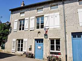
 The town hall in Vaudémont | |
 Coat of arms | |
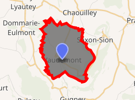
Location of Vaudémont 
| |
 Vaudémont  Vaudémont | |
| Coordinates: 48°25′03″N 6°03′25″E | |
| Country | France |
| Region | Grand Est |
| Department | Meurthe-et-Moselle |
| Arrondissement | Nancy |
| Canton | Meine au Saintois |
| Intercommunality | Communauté de communes du Saintois |
| Government | |
| • Mayor (2008–2014) | Bernard Haquin |
| Area 1 | 5.76 km2 (2.22 sq mi) |
| Population (2017-01-01)[1] | 63 |
| • Density | 11/km2 (28/sq mi) |
| Time zone | UTC+01:00 (CET) |
| • Summer (DST) | UTC+02:00 (CEST) |
| INSEE/Postal code | 54552 /54330 |
| Elevation | 329–541 m (1,079–1,775 ft) (avg. 460 m or 1,510 ft) |
| 1 French Land Register data, which excludes lakes, ponds, glaciers > 1 km2 (0.386 sq mi or 247 acres) and river estuaries. | |
Sights and monuments
- Château de Vaudémont - ruined 11th-century castle protected as a monument historique by the French Ministry of Culture
gollark: The drones don't have the ability to attain useful data.
gollark: The *maths* is easy.
gollark: The limits on this are drone sensors, not maths.
gollark: It could try going up if it hits an obstruction, or you could just make it stay a large amount above the waypoints and factor this in when creating the path tables.
gollark: When you want to go from A to B, you whatever first search waypoint paths from A to B, then at each waypoint check the position of the next one and fly to it.
See also
| Wikimedia Commons has media related to Vaudémont. |
- "Populations légales 2017". INSEE. Retrieved 6 January 2020.
This article is issued from Wikipedia. The text is licensed under Creative Commons - Attribution - Sharealike. Additional terms may apply for the media files.