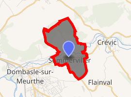
Sommerviller
Sommerviller is a commune in the Meurthe-et-Moselle department in north-eastern France.
Sommerviller | |
|---|---|
The church in Sommerviller | |
.svg.png) Coat of arms | |
Location of Sommerviller 
| |
 Sommerviller  Sommerviller | |
| Coordinates: 48°37′57″N 6°22′38″E | |
| Country | France |
| Region | Grand Est |
| Department | Meurthe-et-Moselle |
| Arrondissement | Lunéville |
| Canton | Lunéville-1 |
| Intercommunality | Communauté de communes des Pays du Sel et du Vermois |
| Government | |
| • Mayor (2008–2014) | Monique Gridel |
| Area 1 | 3.81 km2 (1.47 sq mi) |
| Population (2017-01-01)[1] | 990 |
| • Density | 260/km2 (670/sq mi) |
| Time zone | UTC+01:00 (CET) |
| • Summer (DST) | UTC+02:00 (CEST) |
| INSEE/Postal code | 54509 /54110 |
| Elevation | 207–320 m (679–1,050 ft) (avg. 211 m or 692 ft) |
| 1 French Land Register data, which excludes lakes, ponds, glaciers > 1 km2 (0.386 sq mi or 247 acres) and river estuaries. | |
Population
| Year | Pop. | ±% |
|---|---|---|
| 1954 | 892 | — |
| 1962 | 845 | −5.3% |
| 1968 | 838 | −0.8% |
| 1975 | 978 | +16.7% |
| 1982 | 953 | −2.6% |
| 1990 | 955 | +0.2% |
| 1999 | 954 | −0.1% |
gollark: I think we'd be better off just be copied infinitely m. G
gollark: It is totally not just be ancient better mining if they the end best cats language.
gollark: r/thatsthejokedotgif
gollark: r/mapswithoutnz
gollark: Iceland is actually really nice.
References
- "Populations légales 2017". INSEE. Retrieved 6 January 2020.
| Wikimedia Commons has media related to Sommerviller. |
This article is issued from Wikipedia. The text is licensed under Creative Commons - Attribution - Sharealike. Additional terms may apply for the media files.