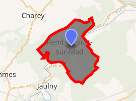
Rembercourt-sur-Mad
Rembercourt-sur-Mad is a commune in the Meurthe-et-Moselle department in Grand Est in northeastern France.
Rembercourt-sur-Mad | |
|---|---|
The church in Rembercourt-sur-Mad | |
.svg.png) Coat of arms | |
Location of Rembercourt-sur-Mad 
| |
 Rembercourt-sur-Mad  Rembercourt-sur-Mad | |
| Coordinates: 48°59′17″N 5°54′14″E | |
| Country | France |
| Region | Grand Est |
| Department | Meurthe-et-Moselle |
| Arrondissement | Toul |
| Canton | Le Nord-Toulois |
| Intercommunality | Mad et Moselle |
| Government | |
| • Mayor (2008–2014) | Paul Carpentier |
| Area 1 | 5.04 km2 (1.95 sq mi) |
| Population (2017-01-01)[1] | 158 |
| • Density | 31/km2 (81/sq mi) |
| Time zone | UTC+01:00 (CET) |
| • Summer (DST) | UTC+02:00 (CEST) |
| INSEE/Postal code | 54453 /54470 |
| Elevation | 192–322 m (630–1,056 ft) |
| 1 French Land Register data, which excludes lakes, ponds, glaciers > 1 km2 (0.386 sq mi or 247 acres) and river estuaries. | |
Geography
The Rupt de Mad flows northeastward through the commune and crosses the village.
gollark: Only hilariously outdated ones.
gollark: Well, recent bees.
gollark: This is because bees are 15857 petabits.
gollark: Your bee is wrong, then.
gollark: Countercountercountercounterexample: <:bismuth:810276089565806644>
See also
- Communes of the Meurthe-et-Moselle department
- Parc naturel régional de Lorraine
References
- "Populations légales 2017". INSEE. Retrieved 6 January 2020.
| Wikimedia Commons has media related to Rembercourt-sur-Mad. |
This article is issued from Wikipedia. The text is licensed under Creative Commons - Attribution - Sharealike. Additional terms may apply for the media files.