Illinois Route 6
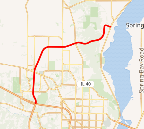
Illinois Route 6 is a 4-lane freeway entirely in Peoria County in central Illinois. It begins as a northern extension of Interstate 474 at Interstate 74 west of Peoria, and ends at Illinois Route 29 at the 9th Mile in Mossville, south of Chillicothe. The freeway currently has a total length of 10.11 miles (16.27 km), including the connector ramp to Illinois 29.[1]
| ||||
|---|---|---|---|---|

IL 6 highlighted in red | ||||
| Route information | ||||
| Maintained by IDOT | ||||
| Length | 10.11 mi[1] (16.27 km) | |||
| Existed | After 1971[2]–present | |||
| Major junctions | ||||
| South end | ||||
| North end | ||||
| Location | ||||
| Counties | Peoria | |||
| Highway system | ||||
| ||||
Route description
Although fairly short, Illinois 6 draws more traffic than a rural highway because it passes through the developing north and northwest edge of Peoria. A one-mile (1.6 km) stretch of road around the U.S. Route 150 (War Memorial Drive) exit has become a major commercial development area that now includes a major mall and a nearby strip mall with over 30 movie screens between them. In addition, new development is occurring rapidly around the other interchanges of Allen Road (old Illinois Route 174), Knoxville Avenue (Illinois Route 40), and Illinois Route 29.
History
SBI Route 6 initially ran from Fulton to Chicago. It roughly followed present-day US 30, Illinois Route 38, and Roosevelt Road.[3] In 1935, Illinois 6 was decommissioned and was partly replaced with US 330 (now IL 38/Roosevelt Road) and US 30.[4]
The Illinois Route 6 designation remained decommissioned until the early 1980s when the present freeway north of Peoria was finished.[5] By 1988, the freeway was extended to Illinois Route 29 near Mossville.[6]
Future
Several plans have been considered for continuing the Illinois 6 corridor. One is extending Illinois 6 into a loop by building a bridge over the Illinois River and running the highway south to Interstates 74 and 474 near Interstate 155 in Morton.[7][8] Another is to build north or northeast from the current terminus to a new interchange in Chillicothe, connecting with a proposed Illinois 29 expressway that would connect to Interstate 180.
In 2013, Illinois Governor Pat Quinn proposed a $12.3 billion road plan that earmarked funds for engineering work and corridor studies, renewing interest in connecting Route 6 with I-74.[9]
Exit list
The entire route is in Peoria County.
| Location | mi[1] | km | Exit[10] | Destinations | Notes |
|---|---|---|---|---|---|
| | 0.00 | 0.00 | Continuation beyond I-74; serves Peoria International Airport | ||
| 0 | I-74 exit 87B; southern terminus & signed as exits 0A (west) & 0B (east) | ||||
| Peoria | 2.32 | 3.73 | 2 | ||
| 5.51 | 8.87 | 5 | Allen Road | ||
| 6.54 | 10.53 | 6 | |||
| Mossville | 9.18 | 14.77 | 9 | Northern terminus | |
| 1.000 mi = 1.609 km; 1.000 km = 0.621 mi | |||||
References
- Illinois Technology Transfer Center (2006). "T2 GIS Data". Retrieved 2007-11-08.
- Carlson, Rick. (2006-03-15). "Illinois State Highways Page: Routes 1 thru 20". Retrieved 2006-03-24..
- Illinois Secretary of State; Rand McNally (1934). Official Road Map Illinois (Map). [c. 1:950,000 and c. 1:1,110,000]. Springfield: Illinois Secretary of State. OCLC 183709045 – via Illinois Digital Archives.
- Illinois Secretary of State; H.M. Gousha (1935). Official Road Map Illinois (Map). [c. 1:950,000 and c. 1:1,110,000]. Springfield: Illinois Secretary of State – via Illinois Digital Archives.
- Illinois Department of Transportation (1983). Illinois Highway Map (Map) (1983–1984 ed.). [1:762,500]. Springfield: Illinois Department of Transportation – via Illinois Digital Archives.
- Illinois Department of Transportation (1987). Illinois Highway Map (Map) (1987–1988 ed.). [1:762,500]. Springfield: Illinois Department of Transportation – via Illinois Digital Archives.
- "Eastern Bypass Study (Official website)". Retrieved 28 July 2020.
- "Eastern Bypass Project Study". Retrieved 28 July 2020.
- Kaergard, Chris (April 18, 2013). "Quinn's $12.6B road plan includes rebuilding McClugage Bridge". PJStar.com. Peoria, Illinois: GateHouse Media. Retrieved 2015-04-30.
- Sarjeant, Charles (2006-10-05). "Illinois Highway Ends: Illinois Route 6". Archived from the original on 2012-03-09. Retrieved 2006-10-28.
