U.S. Route 287 in Texas
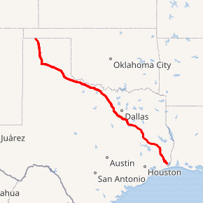
U.S. Highway 287 (US 287) in the U.S. state of Texas is a major U.S. Highway that begins on the Gulf Coast in Port Arthur and heads north through Fort Worth, northwest to Childress, Clarendon, Wichita Falls, and Amarillo in the Texas Panhandle and into Oklahoma near Kerrick.
| ||||||||||
|---|---|---|---|---|---|---|---|---|---|---|
US 287 highlighted in red | ||||||||||
| Route information | ||||||||||
| Auxiliary route of US 87 | ||||||||||
| Maintained by TxDOT | ||||||||||
| Length | 503.898 mi[1][note 1] (810.945 km) | |||||||||
| Existed | 1942–present | |||||||||
| Major junctions | ||||||||||
| South end | ||||||||||
| North end | ||||||||||
| Location | ||||||||||
| Counties | Jefferson, Hardin, Tyler, Polk, Trinity, Houston, Anderson, Freestone, Navarro, Ellis, Johnson, Tarrant, Wise, Montague, Clay, Wichita, Wilbarger, Hardeman, Childress, Hall, Donley, Armstrong, Carson, Potter, Moore, Sherman, Dallam | |||||||||
| Highway system | ||||||||||
| ||||||||||

Route description
US 287 crosses into Texas at Kerrick and continues southeast through to Stratford, where it takes a more southerly turn. In Dumas, US 287 merges with its "parent route", US 87, and continues its south/southeasterly path as a co-signed route to Amarillo.
After passing through the heart of downtown Amarillo, US 87 splits off to the south to merge with I-27, and US 287 merges with I-40 and continues co-signed with the interstate until just west of Rick Husband Amarillo International Airport, where it veers to the southeast toward Claude, the seat of Armstrong County.
US 287 follows this east-southeasterly path through Clarendon and Childress, where it intersects US Highways 83 and 62. US 287 then proceeds to Vernon, where it merges with (and is briefly co-signed with) US 70 and US 183. After US 70 and US 183 leave the route at Oklaunion and veer to the northeast, US 287 resumes its east-southeasterly track passing through Harrold and Electra on its way to Wichita Falls. On the northwest side of the city US 287 merges with I-44, US 82, and (briefly) US 277. After leaving Wichita Falls, US 82/287 continues as a co-signed route until Henrietta, where US 82 leaves the route. After merging with US 81 in Bowie, US 287/81 continues southeast to Fort Worth, where it merges with I-35W on the north side of town. Just northwest of this interchange, Business US 287 veers off to the right following the original routing into Saginaw and into downtown Fort Worth while zig zagging its way through city streets to Kennedale and Mansfield before coming out onto the US 287 Freeway south of Interstate 20 near the Ellis County line just north of Midlothian.
Here, US 81 hits its terminus, but US 287 continues, concurrent route with I-35W through to the north end of downtown Fort Worth before splitting off to the southeast and once again picking up its own signage. This stretch of US 287, which runs from downtown to the southeast side of the city, is also known as the Martin Luther King, Jr. Freeway. In southeast Fort Worth, US 287 intersects with, and is briefly co-signed with, I-820 (which then dumps into I-20) before veering to the southeast yet again, where it passes through the extreme western side of Arlington, and then on in to Mansfield and Midlothian The freeway which previously terminated at the Tarrant/Johnson County line has been extended continuing on into Ellis County to connect with the existing freeway around Waxahachie, which includes a bypass around Midlothian and an interchange with US 67.
After intersecting with I-35E just north of Waxahachie, US 287 continues to the southeast, where it merges with I-45 just south of Ennis and follows the interstate to Corsicana where it then leaves the route and makes another sharp turn to the east. The highway continues southeastward to Palestine, where it merges with State Highway 19. US 287/SH 19 continues as a co-signed route until Crockett, where US 287 leaves SH 19 and continues its southeasterly track toward the Texas Gulf Coast.
In Woodville, US 287 merges with US 69 and takes on a more due-southerly route to Lumberton, where a co-signed US 69/287 also merges with US 96. The highway then continues to the southeast through Beaumont with a short stint with Interstate 10 and on to Port Arthur, where the route terminates at an intersection with State Highway 87.[2]
History
When US 287 was first commissioned in 1935, none of its route was in Texas. The route was extended southward from Colorado to the Gulf Coast at Port Arthur, Texas in 1939. Before this extension, the portion from the Oklahoma state line to Amarillo was SH 9, from Amarillo to Henrietta was SH 5, Henrietta to Bowie was SH 50, Bowie to Fort Worth was SH 2 and US 81, Fort Worth to Ennis SH 34, Ennis to Corsicana was SH 14/US 75, Corsicana to Palestine was SH 22, Palestine to Crockett was SH 19, Crockett and Woodville was Texas State Highway 106, Woodville to Port Arthur was SH 8.

From 1926 to 1939, the aforementioned state routes between US 66 in Claude and US 81 in Bowie were co-designated with U.S. Route 370, which was commissioned in 1926. US 370 was extended westward to Amarillo by 1935 with the northward relocation of US 66. This route also traveled concurrently with US 70 between Vernon and Wichita Falls, Texas. With the 1939 general re-description of the Texas State Highway system all of the state highway designations were removed and US 370 was decommissioned from Oklahoma state line to Port Arthur. SH 106 was decommissioned entirely.
Future
Currently in Beaumont a construction project is widening the highway from four lanes to six lanes for a future Interstate Corridor for US 96 to connect to future Interstate 14. Between Ennis and Waxahatchie the highway is getting grade separated interchanges and service roads.
Major intersections
| County | Location | mi | km | Destinations | Notes | |||
|---|---|---|---|---|---|---|---|---|
| Jefferson | Port Arthur | 0.0 | 0.0 | Southern terminus of US 287, US 69, and US 96; south end of US 69 / US 96 overlap | ||||
| see US 96 | ||||||||
| Hardin | | 30.2– 30.8 | 48.6– 49.6 | Interchange; north end of US 96 overlap | ||||
| Lumberton | 32.6 | 52.5 | ||||||
| | 40.7 | 65.5 | ||||||
| Kountze | 43.5 | 70.0 | ||||||
| 44.2 | 71.1 | |||||||
| | 49.0 | 78.9 | ||||||
| | 51.2 | 82.4 | ||||||
| Village Mills | 54.7 | 88.0 | ||||||
| Tyler | | 58.0 | 93.3 | |||||
| Warren | 62.1 | 99.9 | south end of FM 1943 overlap | |||||
| 62.5 | 100.6 | north end of FM 1943 overlap | ||||||
| Hillister | 66.4 | 106.9 | ||||||
| Woodville | 74.8 | 120.4 | ||||||
| 75.2 | 121.0 | North end of US 69 overlap | ||||||
| | 83.5 | 134.4 | ||||||
| Chester | 90.1 | 145.0 | south end of FM 1745 overlap | |||||
| 90.4 | 145.5 | north end of FM 1745 overlap | ||||||
| Polk | | 96.0 | 154.5 | |||||
| | 100.1 | 161.1 | ||||||
| Corrigan | 104.7 | 168.5 | U.S. 59 is the future Interstate 69 | |||||
| | 112.1 | 180.4 | ||||||
| Trinity | | 122.1 | 196.5 | |||||
| Groveton | 123.5 | 198.8 | ||||||
| 123.6 | 198.9 | South end of SH 94 overlap | ||||||
| 123.8 | 199.2 | |||||||
| | 124.9 | 201.0 | ||||||
| | 126.1 | 202.9 | North end of SH 94 overlap | |||||
| | 129.9 | 209.1 | ||||||
| | 134.7 | 216.8 | ||||||
| Houston | | 135.9 | 218.7 | |||||
| Shady Grove | 141.2 | 227.2 | ||||||
| Crockett | 149.7 | 240.9 | ||||||
| 151.1– 151.2 | 243.2– 243.3 | south end of SH 19 overlap; traffic circle around Houston County Courthouse | ||||||
| 151.4 | 243.7 | |||||||
| 152.6 | 245.6 | |||||||
| | 154.3 | 248.3 | ||||||
| Latexo | 156.8 | 252.3 | ||||||
| Grapeland | 162.9 | 262.2 | ||||||
| 163.5 | 263.1 | |||||||
| 164.4 | 264.6 | |||||||
| 164.8 | 265.2 | |||||||
| | 165.8 | 266.8 | ||||||
| Anderson | | 174.2 | 280.3 | South end of SH 294 overlap | ||||
| Elkhart | 175.7 | 282.8 | ||||||
| 176.0 | 283.2 | North end of SH 294 overlap | ||||||
| | 181.6 | 292.3 | ||||||
| Palestine | 183.9 | 296.0 | ||||||
| 185.7 | 298.9 | South end of US 84 overlap | ||||||
| 186.1 | 299.5 | North end of SH 19 overlap | ||||||
| 186.4 | 300.0 | |||||||
| 186.9 | 300.8 | North end of US 84 overlap | ||||||
| 187.3 | 301.4 | South end of SH 19 overlap | ||||||
| 188.0 | 302.6 | interchange | ||||||
| | 190.0 | 305.8 | North end of SH 19 overlap | |||||
| | 192.1 | 309.2 | ||||||
| | 198.2 | 319.0 | ||||||
| | 199.5 | 321.1 | ||||||
| | 201.3 | 324.0 | ||||||
| | 202.5 | 325.9 | ||||||
| Bethel | 207.4 | 333.8 | ||||||
| Cayuga | 211.8 | 340.9 | ||||||
| Freestone | | 218.7 | 352.0 | |||||
| Navarro | | 222.9 | 358.7 | |||||
| | 228.2 | 367.3 | ||||||
| Eureka | 232.6 | 374.3 | ||||||
| 233.0 | 375.0 | |||||||
| | 238.5 | 383.8 | ||||||
| | 239.2 | 385.0 | ||||||
| Corsicana | 242.1 | 389.6 | South end of I-45 overlap; US 287 south follows exit 229 | |||||
| see I-45 | ||||||||
| Ellis | Ennis | 259.9 | 418.3 | North end of I-45 overlap; US 287 north follows exit 247 | ||||
| 262.8 | 422.9 | |||||||
| 264.7 | 426.0 | Interchange | ||||||
| 265.7 | 427.6 | Lampasas Street | interchange; no direct northbound exit (signed at SH 34) | |||||
| 266.3 | 428.6 | interchange | ||||||
| Waxahachie | 275.2 | 442.9 | interchange | |||||
| 278.5 | 448.2 | interchange; south end of freeway | ||||||
| 279.2 | 449.3 | Farley Street / Broadhead Road | no direct northbound exit | |||||
| 279.4 | 449.7 | |||||||
| 280.3 | 451.1 | |||||||
| 281.9 | 453.7 | I-35E exit 403 | ||||||
| 283.1 | 455.6 | no direct northbound exit | ||||||
| 284.3 | 457.5 | interchange; north end of freeway | ||||||
| Midlothian | 289.7 | 466.2 | interchange; south end of freeway | |||||
| 290.9 | 468.2 | |||||||
| 292.4 | 470.6 | no direct southbound exit to US 67 north (signed at US 287 Bus.) | ||||||
| 293.4 | 472.2 | interchange; north end of freeway | ||||||
| Grand Prairie | 296.8 | 477.7 | ||||||
| Mansfield | 298.4 | 480.2 | South end of SH 360; interchange opened May 2018[3] | |||||
| Johnson | 299.5 | 482.0 | interchange | |||||
| Tarrant | 300.7 | 483.9 | Heritage Parkway | interchange; south end of freeway | ||||
| 301.7 | 485.5 | Access to Methodist Mansfield Medical Center | ||||||
| 303.1 | 487.8 | Walnut Creek Drive / Debbie Lane | ||||||
| 304.5 | 490.0 | |||||||
| Mansfield–Arlington city line | 305.8 | 492.1 | Turner-Warnell Road / Callender Road | |||||
| Arlington | 306.8 | 493.7 | Russell-Curry Road / Eden Road | |||||
| 308.6 | 496.6 | Kennedale-Sublett Road | ||||||
| 310.3 | 499.4 | Little Road - Kennedale | ||||||
| 310.8 | 500.2 | South end of I-20 overlap; US 287 south follows exit 444 | ||||||
| Fort Worth | 312.6 | 503.1 | North end of I-20 overlap; south end of I-820 overlap; US 287 north follows exit 442B; US 287 south follows exit 34A | |||||
| 313.3 | 504.2 | Sun Valley Drive | I-820 exit 33C | |||||
| 313.9 | 505.2 | Martin Street | I-820 exit 33B; no northbound entrance | |||||
| 314.2 | 505.7 | North end of I-820 overlap; US 287 north follows exit 33A | ||||||
| 314.7 | 506.5 | Village Creek Road | ||||||
| 315.5 | 507.7 | Wilbarger Street / Miller Avenue | ||||||
| 316.7 | 509.7 | Berry Street / Vaughn Boulevard | ||||||
| 317.8 | 511.4 | Mitchell Boulevard | ||||||
| 318.2 | 512.1 | Cobb Park Drive | Southbound exit and northbound entrance | |||||
| 318.7 | 512.9 | Rosedale Street | ||||||
| 319.2 | 513.7 | Vickery Boulevard | no direct northbound exit (signed at Rosedale Street) | |||||
| 319.3 | 513.9 | Riverside Drive | ||||||
| 320.0 | 515.0 | no northbound exit; SH 180 is former US 80 | ||||||
| 320.1 | 515.2 | I-30 exit 15A; south end of US 377 overlap | ||||||
| southbound exit and northbound entrance; I-30 exits 15B-C | ||||||||
| 320.5 | 515.8 | Chambers Street | no southbound exit | |||||
| 320.9 | 516.4 | South end of I-35W overlap; southbound exit and northbound entrance; US 287 south follows exit 51 | ||||||
| I-35W exit 52A, access to Fort Worth Central Station | ||||||||
| see I-35W | ||||||||
| 329.5 | 530.3 | North end of I-35W overlap; south end of US 81 overlap; no southbound exit; US 287 north follows exit 60 | ||||||
| 331.1 | 532.9 | Harmon Road (FM 3479) | ||||||
| 332.7 | 535.4 | |||||||
| 335.5 | 539.9 | Bonds Ranch Road | ||||||
| 335.7 | 540.3 | Blue Mound Road / Willow Springs Road | ||||||
| 337.8 | 543.6 | interchange; north end of freeway | ||||||
| Wise | Rhome | 344.3 | 554.1 | interchange; south end of freeway; south end of SH 114 overlap | ||||
| 344.1 | 553.8 | |||||||
| 345.4 | 555.9 | North end of SH 114 overlap | ||||||
| 346.3 | 557.3 | interchange; north end of freeway | ||||||
| New Fairview | 348.5 | 560.9 | Interchange | |||||
| Decatur | 357.3 | 575.0 | ||||||
| 358.1 | 576.3 | |||||||
| 359.1 | 577.9 | Interchange | ||||||
| 360.3 | 579.8 | Interchange, access to Wise Regional Health System | ||||||
| 361.4 | 581.6 | Interchange | ||||||
| 361.8 | 582.3 | |||||||
| | 362.7 | 583.7 | ||||||
| | 370.0 | 595.5 | interchange; south end of freeway | |||||
| | 370.4 | 596.1 | Hubbard Street | |||||
| Alvord | 371.4 | 597.7 | ||||||
| | 372.5 | 599.5 | interchange; no direct northbound exit; north end of freeway | |||||
| Montague | | 378.1 | 608.5 | interchange; south end of freeway | ||||
| | 379.3 | 610.4 | ||||||
| | 381.1 | 613.3 | Lawhorn Lane | |||||
| | 382.6 | 615.7 | Fruitland Road | |||||
| | 384.5 | 618.8 | Wagonseller Road | |||||
| | 386.2 | 621.5 | North end of US 81 overlap; no northbound entrance; no access from US 287 south to SH 101 | |||||
| Bowie | 386.8 | 622.5 | ||||||
| 388.1 | 624.6 | |||||||
| | 390.5 | 628.4 | interchange; north end of freeway | |||||
| Clay | Bellevue | 398.9 | 642.0 | South end of FM 1288 overlap | ||||
| 399.3 | 642.6 | North end of FM 1288 overlap | ||||||
| | 411.2 | 661.8 | New York Road | interchange southbound; at-grade intersection northbound | ||||
| Henrietta | 413.6 | 665.6 | interchange; south end of freeway | |||||
| 414.6 | 667.2 | |||||||
| | 415.6 | 668.8 | Access Road | |||||
| | 416.7 | 670.6 | interchange; south end of US 82 overlap; north end of freeway | |||||
| Jolly | 424.7 | 683.5 | Interchange | |||||
| | 426.0 | 685.6 | ||||||
| | 428.3 | 689.3 | interchange; south end of freeway | |||||
| | 428.9 | 690.2 | Stephens Ranch Road | no direct northbound exit | ||||
| Wichita | Wichita Falls | 429.8 | 691.7 | Fisher Road | ||||
| 430.5 | 692.8 | Hammon Road | ||||||
| 431.1 | 693.8 | South end of SH 79 overlap; no direct northbound exit (signed at Hammon Road) | ||||||
| 431.9 | 695.1 | Windthorst Road | ||||||
| 432.3 | 695.7 | North end of SH 79 overlap; south end of US 281 overlap | ||||||
| 432.8 | 696.5 | |||||||
| 433.4 | 697.5 | North end of US 82 overlap; south end of US 277 overlap | ||||||
| 433.9 | 698.3 | Broad Street - Business District | northbound exit and southbound entrance | |||||
| 434.7 | 699.6 | south end of I-44 overlap; southbound exit and northbound entrance; I-44 exit 1, access to United Regional Healthcare System | ||||||
| 6th Street - MPEC | no direct southbound exit | |||||||
| 434.9 | 699.9 | no northbound exit; I-44 exit 1A | ||||||
| 435.3 | 700.5 | Scotland Park | I-44 exit 1B; no direct southbound exit | |||||
| 435.9 | 701.5 | Texas Travel Info Center | I-44 exit 1C | |||||
| 436.5 | 702.5 | I-44 exit 1D | ||||||
| 436.8 | 703.0 | Maurine Street | I-44 exit 2 | |||||
| 437.3 | 703.8 | North end of I-44 / US 277 / US 281 overlap; US 287 north follows exit 3A | ||||||
| 438.1 | 705.1 | |||||||
| 439.2 | 706.8 | City View Drive | ||||||
| 440.5 | 708.9 | Wellington Lane | ||||||
| 441.3 | 710.2 | Huntington Lane | ||||||
| 442.2 | 711.7 | |||||||
| | 443.2 | 713.3 | Rifle Range Road | |||||
| | 444.2 | 714.9 | Peterson Road | |||||
| Iowa Park | 445.2 | 716.5 | Bell Road | |||||
| 446.1 | 717.9 | |||||||
| 447.1 | 719.5 | |||||||
| | 449.2 | 722.9 | Harmony Road | |||||
| | 451.7 | 726.9 | Burnett Ranch Road | |||||
| | 455.2 | 732.6 | no southbound exit | |||||
| | 456.3 | 734.3 | ||||||
| | 458.8 | 738.4 | Midway Church Road | |||||
| Electra | 460.7 | 741.4 | ||||||
| 461.8 | 743.2 | |||||||
| Wichita–Wilbarger county line | 463.8 | 746.4 | County Line Road | |||||
| Wilbarger | | 465.0 | 748.3 | interchange; north end of freeway; no direct northbound exit | ||||
| | 468.2 | 753.5 | interchange | |||||
| Harrold | 468.7 | 754.3 | interchange | |||||
| Oklaunion | 380.5 | 612.4 | South end of freeway; southbound exit and entrance | |||||
| 380.9 | 613.0 | interchange; south end of freeway; south end of US 70 / US 183 overlap | ||||||
| 381.6 | 614.1 | no direct northbound exit (signed at US 70 east / US 183 north) | ||||||
| 382.2 | 615.1 | Southbound exit only | ||||||
| | 382.4 | 615.4 | interchange; north end of freeway | |||||
| | 385.4 | 620.2 | Frontage Road | at-grade intersection | ||||
| | 386.1 | 621.4 | interchange; south end of freeway | |||||
| | 387.1 | 623.0 | no direct southbound exit | |||||
| | 387.9 | 624.3 | no direct southbound exit (signed at Laurie Street) | |||||
| Vernon | 389.0 | 626.0 | Laurie Street | |||||
| 389.8 | 627.3 | North end of US 183 overlap | ||||||
| 390.6 | 628.6 | Bentley Street | ||||||
| 391.5 | 630.1 | interchange; north end of freeway; north end of US 70 overlap | ||||||
| | 393.4 | 633.1 | Interchange; south end of FM 925 overlap | |||||
| | 394.5 | 634.9 | North end of FM 925 overlap | |||||
| | 396.7 | 638.4 | Interchange | |||||
| Hardeman | | 403.4 | 649.2 | |||||
| Chillicothe | 405.6 | 652.7 | ||||||
| | 411.1 | 661.6 | ||||||
| | 413.2 | 665.0 | ||||||
| | 417.7 | 672.2 | ||||||
| Quanah | 418.9 | 674.2 | ||||||
| 419.7 | 675.4 | |||||||
| 420.0 | 675.9 | |||||||
| | 424.5 | 683.2 | Interchange | |||||
| | 425.4 | 684.6 | ||||||
| Goodlett | 427.5 | 688.0 | ||||||
| | 428.1 | 689.0 | ||||||
| | 428.5 | 689.6 | ||||||
| | 432.9 | 696.7 | ||||||
| Childress | | 436.1 | 701.8 | |||||
| | 438.1 | 705.1 | South end of FM 1033 overlap | |||||
| Kirkland | 438.4 | 705.5 | North end of FM 1033 overlap | |||||
| | 440.2 | 708.4 | ||||||
| Childress | 446.3 | 718.3 | ||||||
| 446.9 | 719.2 | |||||||
| 447.0 | 719.4 | |||||||
| 447.5 | 720.2 | |||||||
| 448.5 | 721.8 | |||||||
| | 451.4 | 726.5 | Interchange | |||||
| | 453.3 | 729.5 | ||||||
| | 455.7 | 733.4 | ||||||
| Hall | | 462.4 | 744.2 | |||||
| Estelline | 463.2 | 745.4 | ||||||
| | 466.6 | 750.9 | ||||||
| | 473.1 | 761.4 | ||||||
| Memphis | 477.7 | 768.8 | ||||||
| 478.0 | 769.3 | |||||||
| 479.0 | 770.9 | |||||||
| Donley | Hedley | 490.3 | 789.1 | |||||
| Lelia Lake | 497.0 | 799.8 | ||||||
| 497.5 | 800.6 | |||||||
| | 500.7 | 805.8 | ||||||
| Clarendon | 503.8 | 810.8 | South end of SH 70 overlap | |||||
| 504.7 | 812.2 | |||||||
| 505.0 | 812.7 | North end of SH 70 overlap | ||||||
| | 507.0 | 815.9 | ||||||
| Ashtola | 514.3 | 827.7 | ||||||
| Armstrong | Goodnight | 522.9 | 841.5 | |||||
| | 526.4 | 847.2 | ||||||
| | 533.2 | 858.1 | South end of FM 1151 overlap | |||||
| Claude | 533.9 | 859.2 | North end of FM 1151 overlap | |||||
| 534.5 | 860.2 | |||||||
| | 538.9 | 867.3 | ||||||
| | 545.4 | 877.7 | ||||||
| Washburn | 547.2 | 880.6 | ||||||
| Carson |
No major junctions | |||||||
| Potter | | 551.8 | 888.0 | |||||
| | 552.8 | 889.6 | ||||||
| Amarillo | 554.1 | 891.7 | SE 3rd Avenue | Interchange; northbound exit and entrance only | ||||
| 554.5 | 892.4 | South end of I-40 overlap; south end of freeway section; southbound exit and northbound entrance; I-40 exit 78 | ||||||
| see I-40 | ||||||||
| 562.0 | 904.5 | North end of I-40 overlap; south end of US 60 west/US 87 south overlap; I-40 exit 70 | ||||||
| 562.6 | 905.4 | One-way street, inbound access only; southbound entrance only; north end of US 60 west/US 87 south overlap | ||||||
| Northbound entrance only; south end of US 60 east overlap; north end of freeway | ||||||||
| 563.1 | 906.2 | Does not intersect US 287 north (Buchanan Avenue); former Bus. US 66 | ||||||
| 564.2 | 908.0 | North end of US 60 east overlap | ||||||
| Buchanan Street north | Northbound exit only; south end of freeway | |||||||
| 564.7 | 908.8 | Southbound exit only; south end of US 87 overlap | ||||||
| Entrances only; south end of US 87 overlap | ||||||||
| see US 87 | ||||||||
| Moore | Dumas | 611.1 | 983.5 | North end of US 87 overlap | ||||
| | 614.6 | 989.1 | ||||||
| Etter | 621.8 | 1,000.7 | interchange | |||||
| Sherman | | 625.3 | 1,006.3 | |||||
| | 630.3 | 1,014.4 | ||||||
| Stratford | 643.8 | 1,036.1 | ||||||
| 644.1 | 1,036.6 | |||||||
| Dallam | Kerrick | 658.9 | 1,060.4 | |||||
| | 659.1 | 1,060.7 | Oklahoma state line | |||||
1.000 mi = 1.609 km; 1.000 km = 0.621 mi
| ||||||||
Notes
- Length does not account for concurrencies along Interstate Highways and U.S. Highways with lower numbers
Image gallery
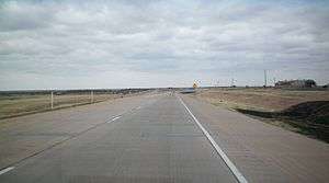
- Approaching US 287 in Mansfield.
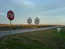
 US 287 runs northwest-southeast through Childress, located equidistant from Amarillo and Wichita Falls.
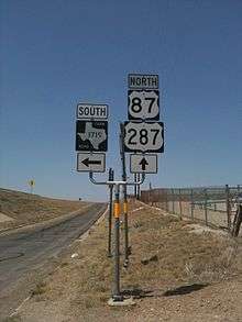 US 287 is concurrent with US 87 between Amarillo and Dumas.
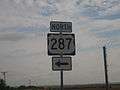
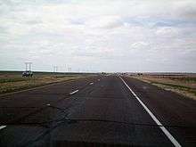 US 287 in North Texas.
See also


References
- Transportation Planning and Programming Division (n.d.). "U.S. Highway No. 287". Highway Designation Files. Texas Department of Transportation. Retrieved March 5, 2008.
- Google (March 5, 2008). "Overview Map of US 287" (Map). Google Maps. Google. Retrieved March 5, 2008.
- https://twitter.com/CityOfArlington/status/994976131047739393
External links
| Wikimedia Commons has media related to U.S. Route 287 in Texas. |
- US 287 southeast of downtown Fort Worth—from dfwfreeways.info
| Previous state: Terminus |
Texas | Next state: Oklahoma |