U.S. Route 60 in Texas
U.S. Highway 60 (US 60) in Texas is a 210.698-mile (339.086 km) long U.S. Highway that runs southwest to northeast through the Texas Panhandle.[1]
| ||||
|---|---|---|---|---|
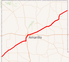
US 60 highlighted in red | ||||
| Route information | ||||
| Maintained by TxDOT | ||||
| Length | 210.698 mi[1] (339.086 km) | |||
| Existed | June 8, 1931–present | |||
| Major junctions | ||||
| West end | ||||
| East end | ||||
| Location | ||||
| Counties | Parmer, Castro, Deaf Smith, Randall, Potter, Carson, Gray, Roberts, Hemphill, Lipscomb | |||
| Highway system | ||||
| ||||

Route description
US 60 enters Texas from New Mexico at Farwell, having just left a concurrence with U.S. Highways 70 and 84. The route travels northeast through small towns in the western Panhandle, reaching an intersections with U.S. Highway 385 at Hereford. The route continues on, reaching Canyon. There it turns north, and merges with Interstate 27 and U.S. Highway 87. This concurrence continues until it reaches Amarillo. I-27 ceases at the intersection with Interstate 40. US 60 and 87 continue north, being joined by U.S. Highway 287. On the north side on Amarillo, US 60 departs to the east on Amarillo Avenue. This route is currently Business Route 40, and is a portion of Historic Route 66. US 60 and Business I-40 split just northeast of the Amarillo Airport, with US 60 continuing to the northeast. The route passes through Panhandle and Pampa, before reaching a 10-mile (16 km) concurrence with U.S. Highway 83 in Hemphill County. The routes then split again, with US 60 travelling northeast to the Oklahoma state line near Higgins in Lipscomb County.
History
The section of US 60 from New Mexico to Amarillo was originally a portion of the Ozark Trail and paralleled the Panhandle and Santa Fe Railway, part of the Atchison, Topeka and Santa Fe Railway. When Texas began numbering their highway system, the Ozark Trail received the numbering of State Highway 13. By 1920, the entire US 60 route had been renumbered as State Highway 33, or its spur SH 33A, with the northeastern portion also following the AT&SF Railway. By the mid-1920s, the entire route had become an extension of the Abo Pass Highway, and was SH 33 along the entire length. In 1928, the AASHO added the highway to the U.S. Highway System as U.S. Highway 164, with the Texas section being signed in 1929.[2] It was renumbered as US 60 on June 8, 1931, when the route was extended to Los Angeles, California to make it a coast to coast highway.[3]
Major intersections
| County | Location | mi[4] | km | Destinations | Notes | ||
|---|---|---|---|---|---|---|---|
| Parmer | Farwell | 0.000 | 0.000 | Continuation into Texico, New Mexico | |||
| | 0.845 | 1.360 | |||||
| | 3.955 | 6.365 | |||||
| | 4.897 | 7.881 | |||||
| | 11.291– 11.467 | 18.171– 18.454 | |||||
| Bovina | 12.653 | 20.363 | west end of FM 1731 overlap | ||||
| 13.048 | 20.999 | east end of FM 1731 overlap | |||||
| Friona | 24.473 | 39.385 | west end of SH 214 overlap | ||||
| 25.063 | 40.335 | ||||||
| 25.445 | 40.950 | east end of SH 214 overlap; west end of SH 214 Bus. overlap | |||||
| 25.783 | 41.494 | east end of SH 214 Bus. overlap | |||||
| Black | 30.843 | 49.637 | |||||
| 33.212 | 53.450 | ||||||
| Castro | Summerfield | 39.315 | 63.271 | ||||
| Deaf Smith | Hereford | 46.884 | 75.452 | ||||
| 47.394 | 76.273 | ||||||
| 47.901 | 77.089 | ||||||
| 43.830 | 70.538 | ||||||
| | 50.787 | 81.734 | west end of FM 2943 overlap | ||||
| | 52.072 | 83.802 | east end of FM 2943 overlap | ||||
| Dawn | 60.591 | 97.512 | |||||
| Randall | Umbarger | 67.099 | 107.985 | west end of FM 168 overlap | |||
| | 67.644 | 108.862 | east end of FM 168 overlap | ||||
| | 73.726– 73.957 | 118.650– 119.022 | |||||
| Canyon | 77.021 | 123.953 | |||||
| 77.201 | 124.243 | ||||||
| 77.223– 77.902 | 124.278– 125.371 | 15th Street | Interchange; west end of freeway | ||||
| 77.956 | 125.458 | Eastbound exit and westbound left entrance | |||||
| 78.228 | 125.896 | Frontage Road | Eastbound exit only | ||||
| 78.350 | 126.092 | West end of US 87 overlap; westbound left exit and eastbound left entrance | |||||
| 78.463– 79.253 | 126.274– 127.545 | ||||||
| 79.606 | 128.113 | ||||||
| | 80.965 | 130.301 | West end of I-27 overlap; westbound left exit and eastbound left entrance; I-27 exit 110 | ||||
| see I-27 | |||||||
| Potter | Amarillo | 93.814– 94.287 | 150.979– 151.740 | Northern terminus of I-27; east end of I-27 overlap; west end of US 287 south overlap; I-27 exit 123B; I-40 exit 70 | |||
| 94.430 | 151.970 | One-way street, inbound access only; westbound entrance only; east end of US 287 south overlap | |||||
| 94.465 | 152.027 | One-way street, outbound access only; eastbound exit only; east end of freeway; east end of US 87 north overlap (eastbound) | |||||
| 94.591 | 152.229 | Eastbound entrance only; west end of US 287 north overlap; east end of freeway | |||||
| 94.800 | 152.566 | ||||||
| 95.091 | 153.034 | Western terminus of Loop 279 | |||||
| 96.101 | 154.660 | Pierce St. is one-way street, inbound access only; east end of US 87 south overlap (westbound); west end of I-40 Bus. overlap; I-40 Bus. is former US 66 west | |||||
| 96.135 | 154.714 | One-way street, outbound access only; east end of US 287 north overlap | |||||
| 98.228– 98.796 | 158.083– 158.997 | Lake Street | Interchange | ||||
| 98.903 | 159.169 | ||||||
| 101.157– 101.219 | 162.796– 162.896 | Interchange | |||||
| 104.376– 104.868 | 167.977– 168.769 | Parsley Road – Amarillo College East Campus | Interchange | ||||
| 106.214– 106.878 | 170.935– 172.003 | Interchange | |||||
| | 107.131 | 172.411 | East end of I-40 Bus. overlap; former US 66 east | ||||
| Carson | | 108.675 | 174.895 | ||||
| | 112.952– 113.870 | 181.779– 183.256 | Interchange | ||||
| | 115.480 | 185.847 | |||||
| Panhandle | 123.036– 123.332 | 198.007– 198.484 | |||||
| 123.282 | 198.403 | ||||||
| 124.224 | 199.919 | ||||||
| White Deer | 136.696 | 219.991 | |||||
| | 139.375 | 224.302 | |||||
| Gray | | 145.160 | 233.612 | ||||
| Pampa | 148.325 | 238.706 | |||||
| 148.616 | 239.174 | ||||||
| 149.715 | 240.943 | west end of SH 152 overlap; access to Pampa Regional Medical Center | |||||
| 150.562 | 242.306 | ||||||
| 152.838 | 245.969 | ||||||
| | 157.279– 157.478 | 253.116– 253.436 | east end of SH 152 overlap | ||||
| | 158.225 | 254.638 | |||||
| Roberts | Miami | 173.011 | 278.434 | ||||
| | 178.757 | 287.682 | |||||
| Hemphill | | 188.678– 189.362 | 303.648– 304.749 | Interchange; west end of US 83 overlap | |||
| Canadian | 196.529 | 316.283 | |||||
| | 198.466 | 319.400 | |||||
| | 198.668– 198.810 | 319.725– 319.954 | east end of US 83 overlap | ||||
| | 201.609– 201.742 | 324.458– 324.672 | |||||
| Glazier | 206.800 | 332.812 | |||||
| Lipscomb | Higgins | 222.229 | 357.643 | ||||
| | 223.794 | 360.162 | Continuation into Oklahoma | ||||
1.000 mi = 1.609 km; 1.000 km = 0.621 mi
| |||||||
References
- Transportation Planning and Programming Division (n.d.). "U.S. Highway No. 60". Highway Designation Files. Texas Department of Transportation. Retrieved October 8, 2019.
- Transportation Planning and Programming Division (n.d.). "U.S. Highway No. 164". Highway Designation Files. Texas Department of Transportation. Retrieved June 24, 2017.
- Weingroff, Richard (June 18, 2003). "U.S. Route 666: "Beast of a Highway"?". Federal Highway Administration. Retrieved August 3, 2019.
- Texas Department of Transportation (2018). "Statewide Planning Map LRS Readout (ArcGIS)". Retrieved October 4, 2019.
| Previous state: New Mexico |
Texas | Next state: Oklahoma |