Farm to Market Road 1125
Farm to Market Road 1125 (FM 1125) is a farm to market road that connects the farming areas of northern Jack County and southern Montague County with Bowie, Texas.[1]
| ||||
|---|---|---|---|---|
| ||||
| Route information | ||||
| Length | 15.1 mi[1] (24.4 km) | |||
| Existed | 1949[1]–present | |||
| Major junctions | ||||
| South end | ||||
| North end | ||||
| Location | ||||
| Counties | Jack, Montague | |||
| Highway system | ||||
| ||||

Route description
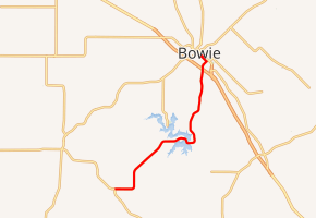
FM 1125 begins in far northeastern Jack County, at an intersection with FM 2127.[2] The two-lane route travels to the northeast, entering Montague County, and crosses the dam along the south shore of Lake Amon G. Carter. East of the lake, the roadway turns to the north and travels through unincorporated Montague County before entering Bowie. FM 1125 has a junction with the US 287 freeway and continues into central Bowie as Rock Hill Road. It turns onto Decatur Street and then Mill Street before state maintenance ends at an intersection with US 81.[1][3]
History
FM 1125 was first designated in Jack County on January 27, 1949; its original designation was from SH 148 between Henrietta and Jacksboro eastward to the community of Postoak. The designation was extended 1.2 miles eastward on December 17, 1952, and then to SH 59 south of Newport on October 24, 1953. The route was first extended 4.8 miles into Montague County on October 31, 1958; the continuation to US 81 in Bowie was established on June 28, 1963, replacing FM 2094.[4] The section from the current western terminus at FM 2127 to SH 148 became a part of FM 2127 on August 16, 1968, bringing FM 1125 to its current routing.[1][5]
Major intersections
| County | Location | mi[6] | km | Destinations | Notes |
|---|---|---|---|---|---|
| Jack | | 0.0 | 0.0 | Southern terminus | |
| Montague | | 7.5 | 12.1 | Bridge over Lake Amon G. Carter | |
| Bowie | 13.8 | 22.2 | |||
| 15.1 | 24.3 | Northern terminus | |||
| 1.000 mi = 1.609 km; 1.000 km = 0.621 mi | |||||
References
- Transportation Planning and Programming Division (n.d.). "Farm to Market Road No. 1125". Highway Designation Files. Texas Department of Transportation. Retrieved 2011-01-12.
- Transportation Planning and Programming Division (2012). Texas County Mapbook (PDF) (Map) (2012 ed.). 1:120,000. Texas Department of Transportation. p. 420. OCLC 867856197. Retrieved 2011-01-12.
- Transportation Planning and Programming Division (2012). Texas County Mapbook (PDF) (Map) (2012 ed.). 1:120,000. Texas Department of Transportation. p. 419. OCLC 867856197. Retrieved 2011-01-12.
- Transportation Planning and Programming Division (n.d.). "Farm to Market Road No. 2094". Highway Designation Files. Texas Department of Transportation. Retrieved 2011-01-12.
- Transportation Planning and Programming Division (n.d.). "Farm to Market Road No. 2127". Highway Designation Files. Texas Department of Transportation. Retrieved 2011-01-12.
- Google (2011-01-05). "Overview map of Farm to Market Road 1125 Distances Between Interchanges" (Map). Google Maps. Google. Retrieved 2011-01-05.